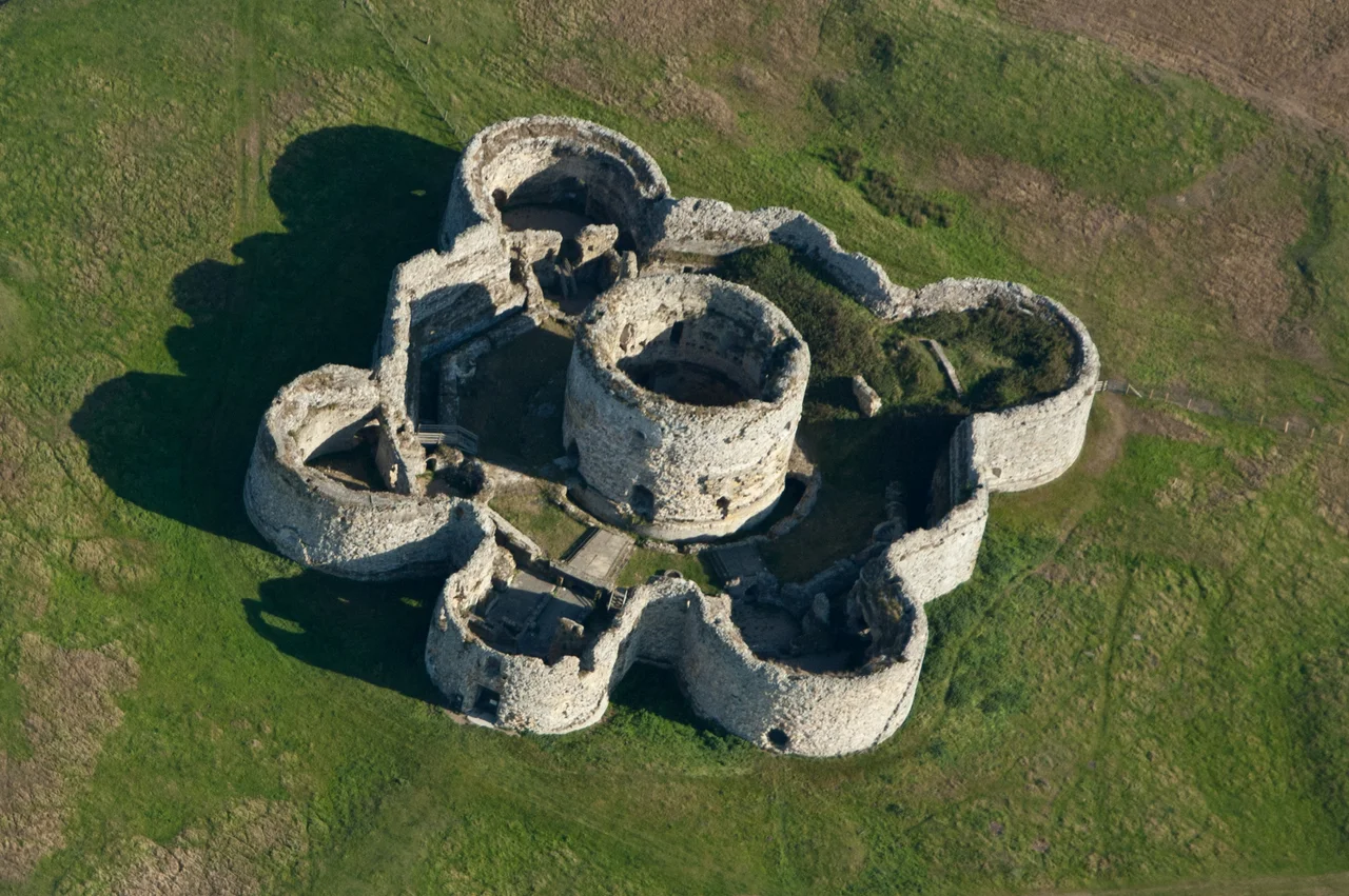

Camber Castle
The castle is a mile from the sea, which is the most important thing about it. Henry VIII built Camber in the 1530s to guard the Rother estuary against French invasion - one of his Device Forts, an artillery castle bristling with bastions and stirrup towers, the cutting edge of Tudor military architecture. Then the sea simply retreated. Shingle piled up on the East Sussex coast, the harbour silted, the strategic threat moved elsewhere, and by 1637 the garrison walked out and left the artillery behind. The empty stone octagon sat in a pasture watching grass grow. Four and a half centuries later, that is largely what it is still doing.
The King's Fortress Network
Camber was one of around thirty Device Forts that Henry VIII ordered built along England's south coast after his break with Rome left him excommunicated and exposed to Catholic invasion. The fort began as a simple round tower in 1512 to 1514, then was massively expanded between 1539 and 1543 into the octagonal artillery castle whose walls still stand. The first captain, Philip Chute, presided from chambers warmed by a special German cocklestove illustrated with Landsknecht soldiers and Protestant German princes - only fragments of it survive. The keep at the centre incorporated 6.7 metres of the original 1514 tower walls; its ground floor had ten gunports, all blocked up when the building was expanded. The outer octagonal wall linked four stirrup towers and four bastions, with a two-storey gallery running around the inside that provided barrack accommodation. The West Bastion was the kitchen, fitted with two circular ovens and a range. Camber was, briefly, formidable.
The Sea Walks Away
The problem with siting an artillery fort to guard a harbour is that harbours move. The shingle that builds the great spit at Dungeness, just along the coast, also chokes the Rother estuary - a slow, geological retreat of the sea that no garrison can fight. By the early 17th century Camber was guarding nothing in particular. Longbows had been obsolete for decades; the castle still kept 46 arquebuses and muskets in 1614. Local towns campaigned to save it, but in 1636 Charles I ordered demolition, and the garrison under Captain Thomas Porter departed the following year. When civil war broke out in 1642 the castle was still being used as a royal munitions store - until the Parliament-loyal citizens of Rye carted the weapons away for safekeeping. Writing in 1785, the antiquarian Francis Grose blamed the castle's irrelevance on the silting harbours and the rise of the Royal Navy, sniffing that its architecture revealed "the low state of military architecture" in 16th-century England.
An Idea That Did Not Happen
Camber had one last brush with military relevance. During the Napoleonic Wars, with Bonaparte massing invasion forces across the Channel, Lieutenant Colonel John Brown surveyed the castle in 1804 to assess whether the central keep could be converted into a Martello tower - the new circular gun towers being built along the coast. The scheme was not taken forward. The coast was much improved by other defences and Camber stayed as it was: stone walls slowly weathering on flat pasture, more pictureseque than dangerous. During the Second World War the British Army made marginal use of the ruin, possibly as an early warning site fitted with anti-aircraft searchlights. Trenches were dug in the north bastion. Then the soldiers left again, and the sheep returned.
The Pasture and the Pit
Walking up to Camber today, the geological story is written in the land itself. The pasture around the castle is just above sea level, marked with low ridges - successive beachlines left by the retreating coast over the centuries. A 1.8 metre defensive earthwork still runs along the south and east sides, once topped by a stone wall meant to keep the sea out. A short stub of raised causeway peters out to the southwest, marking where the lane to the mainland once ran when Camber really was an island fortress in a tidal harbour. To the east lies Castle Water, a 20th-century gravel pit now flooded into a reedy wetland reserve, full of bitterns and avocets and harriers. The castle and the marshes are now run together as part of the Rye Harbour Nature Reserve.
Open Again, At Last
After 1977, when the Department of National Heritage bought Camber from its private owners, archaeologists spent two decades patiently working out what the rubble actually was - the section on Camber in the Ministry of Works' long Device Forts study was finally published in 1982. The castle reopened to the public in 1994 and remains a Grade I listed building, visited today through guided tours from the nature reserve. Inside, you can still trace the underground passages leading from the entrance bastion out beyond the walls - escape routes, or sally ports for ambushing besiegers. The first floor of the entrance bastion would have been the captain's high-status chambers, with large windows, fireplaces, and a private garderobe; most of that storey has been lost. What survives is the geometry of the thing: an octagon of weathered yellow sandstone marooned in green pasture, with the sea a distant rumour.
From the Air
Camber Castle sits at 50.9336 degrees North, 0.7337 degrees East, on flat pasture between Rye and Winchelsea in East Sussex. Best viewed at 1,500 to 2,500 feet AGL in clear weather - the octagonal stone footprint stands out clearly against the green of the Rye Harbour Nature Reserve, with the modern harbour entrance and Camber Sands beach visible to the south. Nearest airfields: Lydd (EGMD) about 8 nautical miles east, Shoreham (EGKA) about 30 nautical miles west. The Channel and the French coast are visible to the south on clear days.
Nearby Stories
- Herstmonceux Castle 2.2 km away
- Tonbridge Priory 7.1 km away
- HMS Niger (1892) 7.9 km away
- Shrub's Wood Long Barrow 8.9 km away
- Battle of the Narrow Seas 13 km away
- Le Paradis Massacre 88 km away
- Courrieres Mine Disaster 145 km away
- D-Day: The Longest Day 160 km away