.jpg)
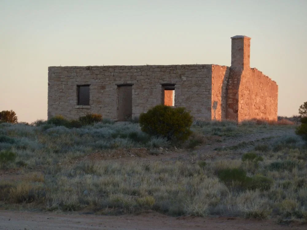
Carcory Homestead Ruin
The men who built this house were the driving force behind the Caulfield Cup. Hold those two facts side by side and the strangeness of Carcory becomes clear. Eighty kilometres north of Birdsville, where the gibber plains shimmer and the nearest neighbour is a rumour, stands a roofless box of rendered limestone. Hector and Norman Wilson, the brothers who raised it in the late 1870s, came from Victorian racing money. Their uncle was Sir Samuel Wilson; their passion was thoroughbreds; their lasting legacy in the south is one of Australia's great horse races. And yet here, in some of the driest grazing land on the continent, they tried to make stone and sheep do what feed and rainfall would not allow.
Stone Against the Sun
The walls tell you everything about the problem the Wilsons faced. There was no timber out here worth building with, and no railway to haul any in. So they built the only way the country allowed: from blocks of local limestone, quarried nearby, raised into walls roughly 45 centimetres thick. The exterior was rendered and scribed to imitate cut ashlar, a little vanity in the wilderness. Two main rooms sat beneath a hipped roof, with a chimney at the northern end and a skillion-roofed wing trailing behind. A separate stone store and kitchen stood to the west. This was a vernacular style that spread across the arid interior, from Robe in South Australia north to Boulia, valued for one reason above all others: thick stone and wide verandahs hold off heat that would make a timber cottage uninhabitable.
The Cattle King's Retreat
Around the turn of the century the place passed to Sidney Kidman, the pastoralist who would become known as the Cattle King. By 1890 his stations already stretched from the Gulf of Carpentaria almost to Adelaide, and he took up the Carcory Run as a thousand square miles of his expanding empire. Then the land did what this land does. Between 1900 and 1903 a savage drought settled over the region, and the entire stock of four thousand bullocks perished. Kidman visited in 1902, did the arithmetic that made him famous, and walked away. He reputedly let the mailman live in the homestead for eighteen months afterward. When he returned, the place stood abandoned and roofless, and the contents had been carried off to Annandale Station.
Borrowed Stone, Slow Ruin
A homestead does not simply collapse out here. It gets disassembled, piece by useful piece. After the First World War, it is believed most of the recoverable material was stripped from Carcory and carted to Glengyle Station, sixty-odd kilometres north, where good building stone was no less scarce. What the salvagers left, the climate and the occasional vandal worked on. The chimney finally fell in around 1992, the same year the ruin was entered on the Queensland Heritage Register. Two years later a heritage grant paid for repairs, and the decision was made to stabilise Carcory as a ruin rather than restore it. The roof was deliberately never replaced. Inside, plastered walls, a fireplace, and the bare heads of door and window frames remain.
A Relic of Hard Ambition
Carcory was established in 1877, one of the earliest pastoral runs in the district, and the towns of Birdsville and Bedourie grew up to service holdings like it. The ruin survives now as something more honest than a restored building could ever be. Its appeal comes partly from its form and partly from its setting, an isolated shell in an enormous open landscape, where the ruinous state and the desolation of the place complete each other. This is a monument to people who arrived with capital and confidence and learned, expensively, what the country was prepared to give. It withholds far more than it grants. The stone outlasted the ambition, which is perhaps the most Channel Country ending a homestead could have.
From the Air
Carcory Homestead Ruin sits at 25.24 degrees south, 139.56 degrees east, roughly 80 km north of Birdsville and about 100 metres east of the Birdsville-Bedourie Road. The pale limestone shell shows up against the surrounding gibber and saltbush, best picked out in low morning or evening light from 1,500 to 3,000 feet AGL. The nearest sealed strip is Birdsville Airport (YBDV) to the south; Bedourie (YBIE) lies to the north and Boulia (YBOU) further again. This is genuinely remote desert flying: carry reserves, expect summer heat haze, and note that surface features along Eyre Creek and the local stock routes make better navigation references than the sparse roads.
Nearby Stories
- Lakes Muncoonie, Mumbleberry and Torquinie Important Bird Area 20 km away
- Lake Machattie Area 23 km away
- Durrie Station 41 km away
- Yarluyandi 43 km away
- Annandale Station 46 km away
- Munga-Thirri National Park 64 km away
- Eromanga Sea 87 km away
- Astrebla Downs National Park 106 km away