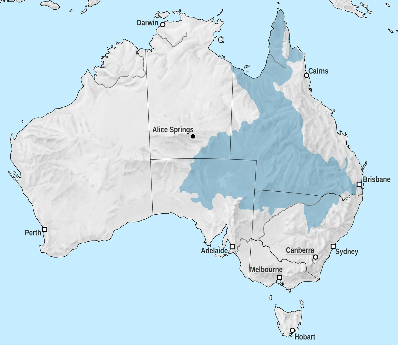

Eromanga Sea
Stand on the cracked clay of the Channel Country, watch the heat shimmer over country that may not see real rain for a year, and you are standing on the bottom of an ocean. Not a poetic one. A real sea, cold and grey and full of monsters, rolled across the heart of this continent in the age of the dinosaurs. Geologists call it the Eromanga Sea, and the proof is underfoot: marine fossils, the remains of swimming reptiles, embedded in sediment hundreds of kilometres from any coastline. The desert remembers the water.
When the Centre Was Submerged
In the Early Cretaceous, roughly a hundred and twenty to ninety-five million years ago, the interior of Australia sagged into a shallow basin, and the sea came in. It flooded the region not once but at least four separate times, advancing and retreating across enormous tracts of what is now Queensland and central Australia. This was no warm tropical lagoon. Australia then sat far closer to the South Pole than it does today, and the inland sea ran cold, muddy, and stagnant, its waters at times near freezing. Drifting ice carried rocks far out to sea and dropped them as the floes melted. Into the mud sank the bodies of the things that died in the water. That cold, oxygen-starved seafloor, hostile to almost everything, would turn out to be one of the great preservers of prehistoric life on the planet.
The Monsters Below
The Eromanga Sea was ruled by reptiles that had returned to the water. Long-necked plesiosaurs, including the elasmosaurs that reached perhaps thirteen metres, patrolled the shallows on paddle-like limbs, sweeping their slender necks through schools of fish. Dolphin-shaped ichthyosaurs hunted at speed. And above them all loomed Kronosaurus, a short-necked pliosaur with a skull longer than a person is tall, one of the most formidable marine predators the continent has ever produced. None of these were dinosaurs; they were their seagoing contemporaries. The sea kept the proof. When these animals died and settled into the cold, anoxic mud, the same lifelessness that starved the seafloor of oxygen also kept scavengers and decay at bay, so that bones which should have crumbled instead lay intact for a hundred million years, waiting for a station hand or a fossil hunter to notice a strange dark shape weathering out of the dirt.
Opal and Bone
The Eromanga Sea did more than drown the centre. It laid down the layers that became the Great Artesian Basin, the immense underground store of water that still keeps the outback alive, and it set the stage for one of Australia's strangest treasures. Where the marine sediments later weathered under acidic, oxidising conditions over tens of millions of years, dissolved silica seeped into cracks and cavities and hardened into opal. Sometimes it filled the very spaces left by shells and bones, turning fossils into gemstones. The same vanished sea that buried the plesiosaurs gave the continent its opal fields, fire and colour conjured from a stagnant ancient ocean.
The Town Furthest From the Sea
There is a fitting irony stamped on the map. The whole drowned interior is named for Eromanga, a small Queensland town that holds an unusual distinction: by Geoscience Australia's reckoning, it is the furthest gazetted town from the ocean anywhere on the continent. The nearest coastline lies many hundreds of kilometres away in every direction. And yet this most landlocked of places gave its name to a sea, because the rocks beneath it were once a seabed. The river plains that finally filled the dying basin became the Winton Formation, now one of the richest dinosaur fossil grounds in the country. The water is long gone. The bones, the opal, and the great hidden reservoir remain, the legacy of an ocean in the middle of a desert.
From the Air
The former Eromanga Sea underlies a huge swath of central and western Queensland; this entry is referenced near 26 degrees south, 140 degrees east, in the Channel Country east of the Simpson Desert. The town of Eromanga lies to the east, served by small regional strips; Birdsville Airport (ICAO YBDV) is the nearest significant field to the west, with Windorah and Quilpie offering alternates toward Eromanga. There is no sea to see, of course: from altitude, look instead for the braided channels of the Diamantina and Cooper systems, the flat clay plains, and the low mesas that expose ancient marine sandstone. Fossil and opal localities are scattered and not visible from the air. Best flown April to October, with generally clear skies and long visibility over the plains.
Nearby Stories
- Birdsville Races 19 km away
- Betoota, Queensland 29 km away
- Carcory Homestead Ruin 47 km away
- Koonchera Point Massacre 55 km away
- Burke and Wills Plant Camp 61 km away
- Arrabury 74 km away
- Cordillo Downs 78 km away
- Morney Plains Station 90 km away