.jpg)
Chimborazo Park
The hill is named after a volcano in Ecuador. Around 1802, the year Alexander von Humboldt tried and failed to climb Chimborazo - then believed to be the highest mountain on Earth - some Richmond world-traveler looked at one of the seven hills east of the city and saw a resemblance to the great Andean volcano. A nearby brewery had dug cellars into the hill to keep beer cool, and the cellar's chimney made fires inside billow smoke through the hilltop like a miniature Vesuvius. The name stuck. Over the next two centuries, this small Richmond hill would host one of the world's largest military hospitals, then a refugee community of newly freed people, then a Boy Scout-built Statue of Liberty, then a quiet neighborhood park overlooking the James River. The history layers on Chimborazo are dense enough that the city council once seriously considered renaming it.
The Hospital That Healed 76,000 Soldiers
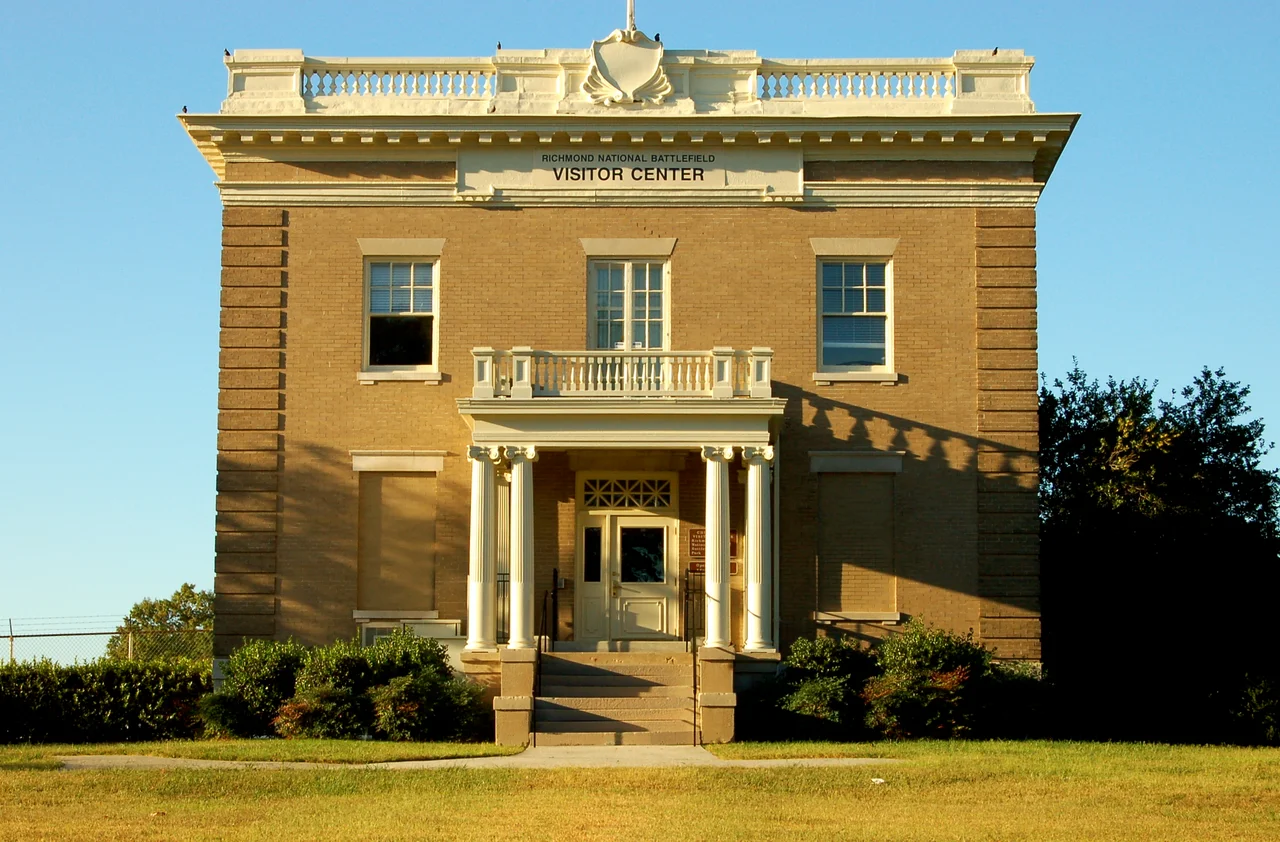
When the Civil War started, the Confederate troops arriving in Richmond camped on Chimborazo Hill and built about 100 wooden barracks for shelter. When they left for the front, the buildings stood empty - a turnkey hospital plant waiting to be used. Samuel P. Moore, the Surgeon General of the Confederate States, commandeered them. From 1862 to 1865, Chimborazo Hospital treated more than 76,000 wounded Confederate soldiers, with up to 4,000 patients at a time. Its 9 percent mortality rate was extraordinary for the era - lower than most civilian hospitals of the time. Phoebe Yates Pember, a chief matron of one of the hospital divisions, would write a memoir of those years that Douglas Southall Freeman called "one of the most fascinating of Confederate books." Today the site is owned by the National Park Service and serves as the visitor center for Richmond National Battlefield Park. A stone placed by the Confederate Memorial Literary Society in 1934 marks the hospital's location, sited carefully to overlook the old Confederate Navy Yard and Rocketts Landing.
The Freedmen's Community
When the war ended, the buildings did not go to waste. The Freedmen's Bureau, charged with helping formerly enslaved people transition to freedom, established a refuge camp on the hill from 1865 to 1866 - using the same barracks that had housed Confederate wounded. Some of the buildings were converted into a day school for Black children. Others were torn down and the wood used for construction or firewood. The community did not last long. In March 1866, the Freedmen's Bureau ordered all able-bodied men to vacate their lodgings by April 1. Over the following years, the City of Richmond purchased the land piece by piece - in many cases through condemnation - slowly forcing out the freed families who had made a community on Chimborazo Hill. By 1880 the city council was auctioning off the last wooden houses. The structures disappeared by about 1900. The people displaced from Chimborazo went where displaced communities always go: into denser, poorer neighborhoods elsewhere in Richmond, their names lost from the official record but not from family memory.
The Park as Public Good
On October 26, 1874, Richmond's Board of Aldermen took up a resolution to purchase 35 acres on Chimborazo Hill for $35,000. The report justifying the purchase is a small marvel of nineteenth-century civic prose: "A public park is simply an expanded idea of our small squares - 'sanitarians' as they are sometimes called. It is the cherished work of every city with any claim to progress and comfort." The resolution passed on November 10, 1874. Construction was slow, but by 1886 the park was being described as "once occupied by a crowd which made night hideous, is now as lovely a spot as can be found." A streetcar line was extended to draw residents. The park was promoted as a "Suburban Resort," complete with pavilions and bandstands. A fountain with colored electric lights was installed in 1909 - the wiring run through electrical poles that proved so ugly that engineers rebuilt the whole thing the next year with the cables buried. The fountain itself was finally pulled out in 1956, rusted beyond repair, leaving a vacant circle at the park's center.
Three Stones and a Tiny Statue
The hill collects monuments. On the south side, overlooking the James River, sits the Powhatan Stone, placed in the 1950s by the Association for the Preservation of Virginia Antiquities. The stone is said to have come from the house of the Powhatan paramount chief - the same man who is supposed to have negotiated with John Smith - and to mark the grave of William Mayo, Richmond's original surveyor. The Mayo family had kept the stone for generations at their home, which they called "Powhatan's Seat," probably built atop the village of the Powhatan's own tribe. A few feet away stands the Civil War hospital marker. And on February 11, 1951, a 100-inch replica of the Statue of Liberty was dedicated in the park - one of approximately 200 distributed by the Boy Scouts of America in their "Strengthen the Arm of Liberty" campaign. Every scout in Richmond's council donated 25 cents toward the project, and their names were sealed in scrolls inside the base. About 3,000 people attended the dedication, including the John Marshall High School Band.
What Stays on Chimborazo
Today the park sits on 27.9 acres owned by the City of Richmond and 5.6 acres owned by the federal government, and it has been part of the Oakwood-Chimborazo Historic District on the National Register since 2005. The Chimborazo Medical Museum, housed in a 1909 weather station, focuses on Confederate medical history and tells the story of the men and women who staffed the hospital - including matrons like Pember and surgeons trained at a time when amputation was still the standard treatment for a wounded limb. The octagonal Round House from 1915 still stands on the east side, overlooking Fulton Bottom. There were calls over the decades to rename the park - "Maury Park" in 1909, "Bloody Run Park" in 1910 - but Chimborazo kept its volcano name, the gift of some forgotten Richmond traveler who once stood in the Andes and remembered home.
From the Air
Chimborazo Park is centered at approximately 37.4292°N, 77.3736°W, on the eastern edge of Richmond overlooking the James River. From the air the hill is part of Richmond's east-side ridgeline; the park itself appears as a green, roughly rectangular space with the octagonal Round House visible on the eastern edge. Recommended viewing altitude 1,500-2,500 feet AGL. Nearest airport: Richmond International (KRIC), 8 miles east; smaller fields include Hanover County (KOFP) to the north. The James River and downtown Richmond are easy visual references; the park is just east of the I-95 corridor where it crosses the river.
Nearby Stories
- Piney Grove at Southall's Plantation 2.5 km away
- Battle of Amelia Springs 3.5 km away
- Lewis Ginter Botanical Garden 4.3 km away
- Cactus Hill 21 km away
- Fork Union Military Academy 25 km away
- Christopher Newport University 44 km away
- Menokin 47 km away
- Long Grass Plantation 65 km away