Cristalino State Park
The arc of deforestation is a phrase that sounds abstract until you trace it on a satellite map. It curves across southern Amazonia from Rondônia through Mato Grosso into Pará, following the road network and the soybean frontier. Where pasture meets forest, the arc advances year by year, a few kilometers at a time. Cristalino State Park sits directly on that arc - a rectangle of intact forest roughly 89 kilometers east to west and 32 kilometers north to south, drawn in 2000 as a deliberate obstruction to the clearing crews moving north. Around it, the farms have advanced on three sides. Inside, the canopy still holds.
Geography of a Stand
The park occupies the extreme north of Mato Grosso, between the broad Teles Pires River to the southwest and the state line of Pará to the north. It spans the municipalities of Alta Floresta and Novo Mundo, though most of its area falls within the latter. In 2001 the creation of the adjacent Cristalino II State Park extended the protected block to a combined 184,900 hectares. The Cristalino River, for which both parks are named, enters from Pará and threads through the heart of the reserve before turning south to join the Teles Pires. The Nhandú River defines the eastern edge, and two low mountain ranges - the Serra do Mateiro in the west and the Serra do Rochedo in the south - give the landscape its vertical relief. To the north, the park meets a Brazilian Air Force base in Pará whose land is also largely undisturbed forest, extending the effective protected area further than the map suggests.
The Ecotone
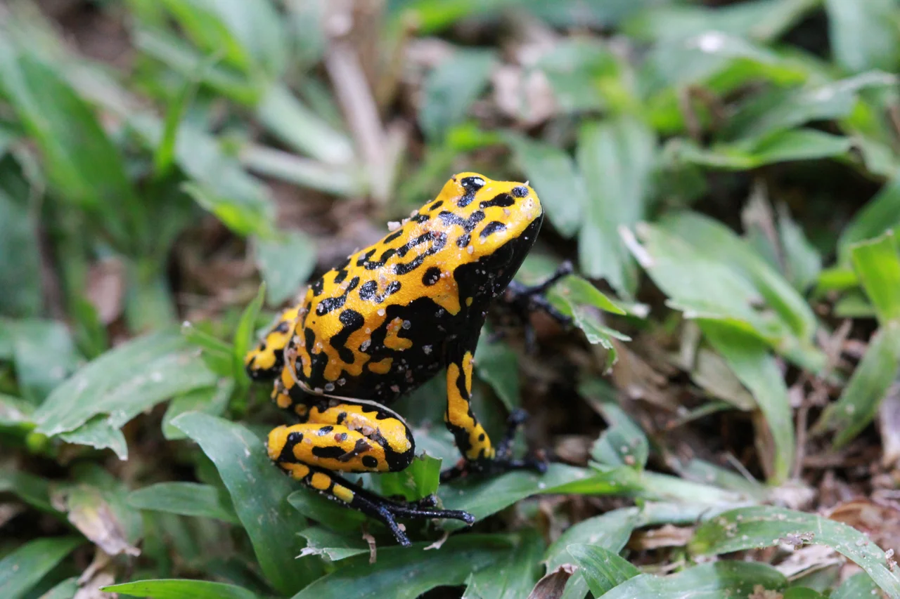
Cristalino sits in the transition zone between the Amazon rainforest proper and the Cerrado savanna to its south - an ecotone where two of South America's great biomes meet and mix. The consequence is extraordinary biodiversity layered in narrow bands. Rainforest gives way to seasonal forest, seasonal forest to campinarana - a sparse, sandy-soiled vegetation type unique to the region - and in places to open rocky fields. Annual rainfall exceeds 2,400 millimeters, and average temperatures stay above 24 degrees Celsius year-round. The dry season runs from May to September, when monthly rainfall can drop below 100 millimeters. Researchers have recorded 515 bird species within the park boundaries, 55 of them endemic, along with 43 reptiles, 29 amphibians, 36 mammals, and 16 fish species of commercial or recreational value.
Getting There, If You Can
Access to Cristalino is deliberately difficult. The most scenic route is by water: the Teles Pires to the mouth of the Cristalino, then up the Cristalino itself through the park. Overland, visitors take the unpaved Quarta Leste road from Alta Floresta, catch a ferry across the Teles Pires, and follow the road as far as the Cristalino River. A second dirt track runs from the Primeira Leste highway, paralleling the Pará border. Beyond these authorized routes, a web of unofficial roads opened by loggers and ranchers pushes into the eastern end of the park, though none reach the Cristalino River basin - yet. The state environmental agency SEMA maintains a small research station within the park: a modest house with four bedrooms, a bathroom, and a generator, used by biologists and graduate students documenting what remains.
The Threats That Never Let Up
Since the park's creation on 9 June 2000, it has been under nearly constant pressure. Illegal logging has steadily advanced north into the park year by year, pulling valuable timber species out before any enforcement can catch up. Cattle ranching nibbles at the edges, and small family agriculture - rice and beans, mostly - takes hold wherever a road provides access. Proposals for small hydroelectric plants periodically surface, threatening to dam the river systems that sustain the forest. Local community support for the park has been limited. For much of its history, enforcement has been nominal. In 2007 a consultative council was finally installed with representatives from civil society and government, and by 2016 the Amazon Region Protected Areas Program was providing support. The pressure, however, has never let up.
Birds and the Business of Hope
The one bright thread has been ecotourism. Private lodges in the region - particularly the famed Cristalino Jungle Lodge on the park's southern edge - have drawn serious birders from around the world for more than two decades. Guests come for glimpses of harpy eagles, zigzag herons, and more antbirds than most people knew existed. The lodges generate income, employ local workers, and make a rare economic case for the forest standing rather than falling. A few hundred visitors a year cannot, by themselves, hold the arc of deforestation in place. But they demonstrate that the canopy has value beyond timber, and that a rectangle of protected Amazon is worth something even to people who will never walk beneath it.
From the Air
Located at 9.53°S, 55.65°W in extreme northern Mato Grosso, Brazil. The park is a roughly rectangular block of forest bounded by the Teles Pires River in the southwest and the Pará state line to the north. Best viewed from 8,000-12,000 feet AGL during dry season (May-September) for clearest visibility. Alta Floresta Airport (SBAT, ICAO AFL) is the nearest significant airstrip, approximately 50 km south. The contrast between the protected rainforest block and the surrounding cleared pasture is striking from altitude.
Nearby Stories
- Cachimbo Airport 37 km away
- Teles Pires Dam 63 km away
- Nascentes da Serra do Cachimbo Biological Reserve 65 km away
- Serra do Cachimbo 88 km away
- Rio Novo National Park 159 km away
- Jamanxim National Forest 198 km away
- Sinop, Mato Grosso 226 km away
- Jaru Biological Reserve 598 km away