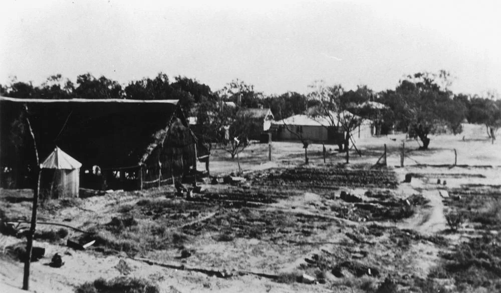

Currawilla
The name is a borrowed word, and it means water. When the stockman Jack Farrar took up a block of country on Farrar's Creek sometime before 1878, he called it Currawilla after the Karuwali name for the waterhole at its heart. It was an honest choice. Out here, on the floodplains between Windorah and Birdsville, a station is only as good as the water it can hold, and Currawilla holds plenty.
A Borrowed Name on Borrowed Country
Farrar was a working man before he was a landholder. He had put in his time at McGregor's Mount Margaret Station, running his own small herd on the side, the way ambitious stockmen did. When he struck out for himself, he followed the Diamantina River down into the Channel Country and settled on roughly a hundred square miles of Farrar's Creek. The land already had a name and a people. This was Karuwali country, and the waterhole he built his homestead beside had been called Currawilla long before any lease was drawn. Farrar kept the word, even as the country changed hands beneath it. The homestead still sits on the Currawilla waterhole, on Torrens Creek, where the first buildings went up more than a century ago.
Floods and Fortunes
The Channel Country runs on extremes, and Currawilla's records read like a ledger of them. Farrar sold to a Mr Cotton, who expanded the holding considerably. By 1881 the property was changing hands again. Then came 1887, and rain like no one had seen: in a single two-day stretch, Currawilla caught eleven inches, part of the heaviest flooding known in the district at that time. Managers came and went. William Henry Watson ran the place through those wet years and by 1889 had bought the station outright. A decade later, in 1897, when drought scorched the surrounding runs, Currawilla came through it gentler than most. It was the old outback pattern: a man manages the country long enough that the country becomes his.
The Patient Plains
Today Currawilla spreads across roughly 2,230 square kilometres, run by Roger and Debbie Oldfield as a working cattle station. It adjoins Palparara and Narradunna, neighbours in a region where the nearest fence line might be a long drive away. The Channel Country defines life here: a vast, almost level plain that the rivers carve into a braid of shallow channels, dry and cracked for years at a time, then suddenly brimming when monsoon rain falls hundreds of kilometres to the north and finds its slow way down. When the floods come, the country greens almost overnight and the cattle fatten on the flush. Then the water recedes, the channels empty, and the waterholes do what waterholes have always done here. They wait.
Where the Travellers Stop
Currawilla sits roughly midway along one of the loneliest stretches of road in Australia, the long haul between Windorah and Birdsville, and that geography has given the old station a second life. Farrar's Creek still runs through the property, and the homestead beside the Currawilla waterhole now welcomes travellers as a station stay, a place to camp and refuel in country where the next services can be a hard day's drive away. It is a fitting turn for a holding whose entire reason for existing was water. The same waterhole that drew Jack Farrar to settle here in the 1870s, the one the Karuwali named long before him, still draws people in. In the outback, the things that matter do not really change. A reliable hole of water is a destination, a landmark, and a kind of promise, and Currawilla has been keeping that promise for the better part of a hundred and fifty years.
From the Air
Currawilla Station lies at 25.15 degrees south, 141.34 degrees east, on Farrar's Creek in the Channel Country of western Queensland, roughly 135 km west of Windorah and 217 km east of Birdsville. From the air, look for the pale braided channels of the floodplain and the darker thread of permanent waterholes marking the creek lines, with the homestead set beside the Currawilla waterhole. The nearest sealed airstrips are at Windorah (YWDH) to the east and Birdsville (YBDV) to the west; Longreach (YLRE) is the major regional aerodrome to the northeast. Visibility is typically excellent in the dry season; expect heat haze and the chance of dust over the bare plains. After major monsoon rains, the surrounding flats can shimmer with sheet water for weeks.
Nearby Stories
- Morney Plains Station 0.4 km away
- Palparara 16 km away
- South Galway Station 22 km away
- Betoota, Queensland 33 km away
- Cooper Floodplain below Windorah 55 km away
- Durrie Station 92 km away
- Astrebla Downs National Park 93 km away
- Warbreccan 110 km away