
Fort Anderson
Two cities lie under the grass here, one on top of the other. Walk the trails at Brunswick Town/Fort Anderson State Historic Site and you are walking across a colonial seaport that thrived for most of the 18th century, then across the sand-and-earth ramparts of a Confederate fort built directly on top of those ruins a hundred years later. The Cape Fear River slides past as it always has, indifferent to which century you happen to be standing in. The brick foundation of St. Philip's Anglican Church still stands roofless among the pines, its walls bracketed by the earthen mounds the Confederates raised when they realized the river itself was Wilmington's last lifeline to the world.
Why the River Mattered
By 1862, every major Southern port save one had been throttled by the Union blockade. Wilmington, twenty miles upstream from the mouth of the Cape Fear, remained open because the river's shifting inlets and treacherous shoals made it murderous to approach without local knowledge. Blockade runners slipped in by night with iron, guns, ammunition, medicine, and European goods the Confederacy could not produce. To protect them, the Confederacy ringed the lower Cape Fear with forts. Fort Anderson, originally called Fort St. Philip after the colonial church it absorbed, was raised by Major General Samuel Gibbs French to guard the western bank. The earthen batteries served as both gun platforms and shock absorbers. Beneath them, troops sheltered in chambers the soldiers called bombproofs, waiting out Union shelling in the dark.
Brunswick Town, Erased and Found
Before the war, before the fort, this was Brunswick Town, founded in 1726 as a Cape Fear shipping hub for naval stores, rice, and timber. It thrived until the American Revolution, when British forces sacked and burned it. The town never recovered. Pines reclaimed the streets, and within a generation people had forgotten where the foundations lay. Lawrence Lee began the search in 1951, walking the overgrown land and recognizing its value. The Orton Plantation owners and the Episcopal Diocese of East Carolina each sold their parcels to the state for one dollar apiece, an act of preservation that has paid out in artifacts ever since. Beginning in 1958, archaeologist Stanley South spent years lifting Brunswick Town back into view. He and his team cataloged some sixty archaeological features, exposing the geometry of streets and the foundations of houses that had been invisible for two hundred years.
The Bombardment
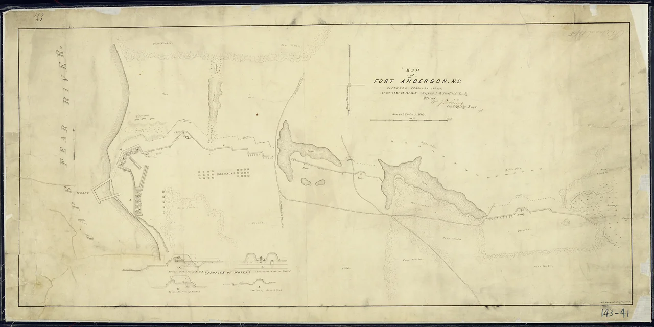
On February 19, 1865, after three days of fighting, Fort Anderson fell to Union forces commanded by Major General John M. Schofield. The map drawn that day, now in the National Archives, shows the fort's saw-toothed earthworks and the line of Union ironclads anchored in the river offshore. With Fort Anderson lost and Fort Fisher already taken downstream, the river was open. Wilmington fell three days later. The blockade runners had nowhere left to run. Confederate supply lines that had survived four years of war collapsed in a week, and the war itself had only two months to live.
What Endures
Visit today and the layers are still legible. The grass-covered earthworks roll across the bluff exactly where French's engineers laid them down. The roofless brick walls of St. Philip's, finished around 1768, stand in the middle of the fort like a stone ghost the Confederates built around rather than knock down. Excavation never really stopped, even when state budgets paused it in 1968. Tom Beaman and field schools from Peace College, UNCW, Wake Tech, and Summer Ventures have returned year after year, working the Civil War barracks site and the colonial layer beneath. The visitor center, opened in April 1967, narrates both stories at once. Filmmakers have used the site too: Sleepy Hollow shot scenes here, casting the colonial ruins as Purgatory.
From the Air
Fort Anderson sits at roughly 34.04 N, 77.95 W on the west bank of the Cape Fear River, about 18 miles south-southwest of downtown Wilmington and roughly opposite Pleasure Island. Best viewed from 2,000-4,000 feet AGL, the earthworks read as low geometric ridges along the bluff, with the brick shell of St. Philip's Church visible as a small rectangle in their midst. Nearest field is Wilmington International (KILM) about 20 miles north; Cape Fear Regional Jetport (KSUT) at Oak Island lies 12 miles south.
Nearby Stories
- Lake Waccamaw, North Carolina 11 km away
- Ocean Isle Beach house fire 14 km away
- Topsail Beach, North Carolina 25 km away
- Marine Corps Base Camp Lejeune 35 km away
- HMT Bedfordshire 63 km away
- Huntington Beach State Park 67 km away
- Atalaya Castle 114 km away
- Mercury-Redstone 4 707 km away