Iron Gates
Ada Kaleh was the size of a Manhattan neighborhood. Three kilometers downstream from Orsova, in the middle of the Danube where Romania, Serbia, and what was once Hungary met, the islet measured about 1.7 kilometers long and barely half a kilometer across. It had a mosque. A bazaar. A thousand twisting alleys. Roughly 500 people lived there in the years before the dams went up, mostly Muslim Turks whose ancestors had garrisoned the fortress for the Ottoman sultan. Smaller communities of Romanians, Hungarians, and Germans lived alongside them. The island was famous for its Turkish coffee, its rose preserves, and a curious legal status: when the 1878 Congress of Berlin pushed the Ottoman Empire south, the treaty had simply forgotten to mention Ada Kaleh, and the island remained Turkish until 1923. In 1972, the gates of the Iron Gate I dam closed and the river rose 35 meters. The mosque, the bazaar, the thousand alleys, the gardens, all of it went under. The people had been relocated. The island was gone.
Where the Mountains Pinch the River
The Iron Gates is the gorge where the Danube cuts through the southern Carpathians on the Romanian side and the northwestern foothills of the Balkan Mountains on the Serbian side. In the broad sense the route runs 134 kilometers. In the narrow sense the Iron Gates is the final barrier just downstream of Orsova, where two hydroelectric dams now stand. The first narrowing, the Golubac gorge, runs 14.5 kilometers and pinches to 230 meters wide at its tightest point. Then come Gospodjin Vir, narrowing to 220 meters with cliffs scaling 500 meters above the water. Then the Donji Milanovac valley opens out before the Great and Small Kazan gorges combine for 19 kilometers of dramatic narrows. Kazan means cauldron in Serbian and Turkish. The Great Kazan is the most famous: 150 meters wide, 53 meters deep, the river squeezed between vertical cliffs that throw echoes back at any boat that passes.
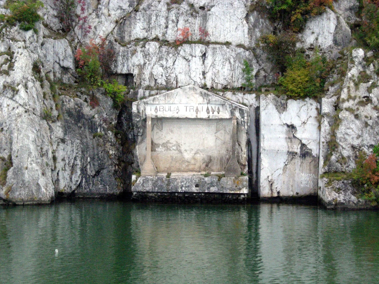
Trajan's Bridge and Decebalus's Face
Just east of the Great Kazan, the Roman emperor Trajan built one of the wonders of antiquity. In 103 to 105 AD, the Greek architect Apollodorus of Damascus engineered a stone bridge across the Danube to allow Trajan's legions to attack the Dacian kingdom of Decebalus. The bridge stood for fewer than two centuries before later emperors dismantled it as a defensive measure, but the masonry pile-bases remain visible at low water on the Romanian and Serbian banks. A Roman plaque called the Tabula Traiana commemorates the campaign on the Serbian side. On the Romanian bank, at the Small Kazan, modern Romanian sculptors carved a 40-meter-tall likeness of King Decebalus into the cliff face between 1994 and 2004, the largest rock relief in Europe. Decebalus stares across the river toward Trajan's plaque, an art-historical conversation between the conquered and the conqueror that took 1,800 years to compose.
Lepenski Vir, Older Than Almost Anything
In 1965 the Serbian archaeologist Dragoslav Srejovic, working on a salvage dig before the Iron Gate I reservoir flooded the site, uncovered a settlement on the Serbian bank that was older than almost any organized human community known. Lepenski Vir, occupied between roughly 7,200 and 6,000 BC, contained 136 trapezoidal house foundations carefully arranged on terraced river bank, with sandstone sculptures of fish-faced human figures placed near hearths. Archaeologists call the surrounding culture the Iron Gates Mesolithic. People had lived in this gorge for at least 13,000 years. The whole village was disassembled and moved upslope to escape the rising water. You can visit it today in a covered enclosure on a cliff that is now several stories above the lake the dam created.
Pilots Through the Cataracts
Before the dams, the Iron Gates was an infamous obstacle for navigation. Rocks studded the riverbed. Rapids broke against ledges. Whirlpools spun in the narrows. During Ottoman rule, ships were guided through by local navigators called kalauz, from the Turkish kalavuz meaning guide. After the Serbian principality won autonomy under Milos Obrenovic in the early 19th century, Serbian pilots gradually replaced Ottoman ones, but to avoid offending Constantinople, the prince gave them the Turkish title dumendzibasa, from dumen meaning rudder and bas meaning chief. Hungary's iron-willed Minister of Transport Gabor Baross drove the great 19th-century improvement project. From 1889 to 1896, Hungarian engineers blasted channels through the worst obstacles. The Sip Canal was inaugurated on 17 September 1896 by the Austro-Hungarian Emperor Franz Joseph, the Romanian King Carol I, and the Serbian King Alexander Obrenovich, three monarchs who could agree at least about the value of clearing rocks from a river.
What the Dams Took, What They Gave
Construction of the joint Romanian-Yugoslav project began in 1964. The Iron Gate I Dam opened in 1972. Iron Gate II followed in 1984. Together they generate substantial hydroelectric power for both countries and have made the gorge fully navigable for modern shipping with sluices and locks. The price was high. Beyond Ada Kaleh, the old town of Orsova and at least five other villages were submerged, displacing about 17,000 people. Migratory fish, particularly the great Danube sturgeon, lost their spawning routes. The largest beluga sturgeon ever recorded weighed 500 kilograms when it was caught in 1793; that population has effectively vanished above the dams. Both nations created national parks, the Djerdap on the Serbian side in 1974 and the Iron Gates Natural Park on the Romanian side in 2001, to protect what remained of the gorge's flora, fauna, and archaeological record. UNESCO designated the Serbian side a Global Geopark in July 2020. The Iron Gates today remains one of Europe's most dramatic landscapes. It is also a memorial to a vanished island and to the riverine cultures that the 20th century, in its hunger for power, paved over.
From the Air
Located at 44.671 degrees north, 22.530 degrees east, on the Danube on the border between Serbia and Romania. Iron Gate I dam is the most prominent landmark. The nearest airports are Belgrade Nikola Tesla (LYBE), 200 kilometers west, and Craiova (LRCV), 150 kilometers northeast. From cruising altitude the gorge appears as a dramatic dark slash through the wooded mountains, with the Danube widening to several kilometers behind the dams and pinching to under 200 meters in the Kazan narrows. The artificial lakes upstream stretch for 130 kilometers.
Nearby Stories
- Domogled-Valea Cernei National Park 11 km away
- New Europe Bridge 56 km away
- Sarmizegetusa Regia 70 km away
- Buila-Vanturarita National Park 90 km away
- Church of Saint George, Sofia 198 km away
- Old Bazaar, Skopje 281 km away
- 1963 Skopje Earthquake 310 km away
- Budapest 366 km away