Jur River
The Jur is a river that knows how to disappear. It rises in the red-earth hills along the border between South Sudan and the Democratic Republic of the Congo, gathers a handful of tributaries near the town of Wau, and then bends eastward into a wetland so vast and so shape-shifting that geographers have been arguing for a century about exactly where the Jur ends and something else begins. Some maps say it joins the Bahr el Ghazal at Lake Ambadi. Other maps draw the confluence further downstream. The river itself has opinions on neither question. In September it runs hard enough to move 400 cubic meters per second. By February its channels have split into threads of standing water among the papyrus, and the question of where a river goes stops mattering as much as what it feeds.
The Divide That Feeds It
The Jur is born on the Congo-Nile watershed, a low ridge running through the miombo woodlands of South Sudan's far west. On one side of this divide, rainfall drains eventually to the Atlantic via the Congo. On the other, it flows to the Mediterranean via the Nile, a journey of roughly 4,500 kilometers with only a 1,200-meter drop along the way. The Jur's headwaters join near Wau, capital of Western Bahr el Ghazal State: the Sue River, the Busseri, the Wau, the Numatinna. The names shift between languages, between sources, between colonial cartographers who passed through briefly and local speakers who have known the rivers all their lives. Among the Luo people who fish its banks, the Jur is simply the Luo River, and the Sue, its upper course, is also called the Jur, which is one reason the maps argue with each other.
An Explorer's River
The Jur's entry into European knowledge came through John Petherick, a Welsh mining engineer who turned ivory trader, then British vice-consul in Khartoum, and finally explorer. Between 1853 and 1865 he followed the river through territory where the Khartoum slave trade was at its most violent, a conflict of interest he never satisfactorily resolved. A generation later, between 1897 and 1898, Lieutenant A.H. Dyé and a team under Jean-Baptiste Marchand surveyed the Jur's full course as part of France's bid to draw a line of influence across Africa. That survey ended at Fashoda, where Marchand's men stood off the British and nearly triggered a war between Europe's great powers. The river itself took no side. It went on seasonally flooding the same villages, feeding the same herds, losing itself in the same swamps.
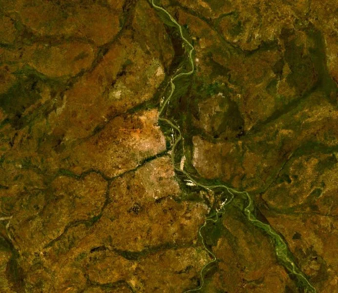
The Swamp That Swallows It
East of Wau, the gradient falls almost to nothing. The Jur slows, broadens, and enters the Bahr el Ghazal system, the great northwestern lobe of the Sudd wetlands. Here the distinction between river and swamp blurs. Papyrus stands twenty feet tall. Channels open, close, braid, and reweave between wet and dry seasons. Lake Ambadi, fed by the Jur and a dozen other streams, is sometimes a lake, sometimes a shallow pan, sometimes a labyrinth of reed-walled passages navigable only by someone who grew up poling a dugout through them. The Dinka, Luo, and Jur Chol communities who live along this watery edge read the landscape by markers outsiders cannot see: the slight rise of a termite mound, a particular bend of a palm, the sound of a certain bird calling from the far bank.
Water That Does Not Reach
Here is one of the strangest facts about the Nile basin: most of the water that enters the Sudd from its southwestern tributaries never leaves. It evaporates, transpires through miles of vegetation, vanishes into air. The Jur pours roughly 400 cubic meters per second into the wetlands at peak flow, and yet the Bahr el Ghazal River downstream is often a trickle compared to its contributions. This was the calculation that fascinated colonial hydrologists: all that water, seemingly wasted. It was also the calculation that produced the Jonglei Canal, the unfinished scheme to drain the Sudd and send its water downstream to Egypt. The Jur flows on regardless, feeding a swamp that feeds fish and cattle and two million seasonal migrants, and the lesson of the river is that wasted water is a concept that depends entirely on who you think the water is for.
From the Air
The Jur River rises near 5°N, 28°E on the Congo-Nile divide and flows north-northeast approximately 485 km to merge with the Sudd wetlands near 8.65°N, 29.3°E. At cruising altitudes the river is most visible in the wet season (July-October) when it runs high. Nearest airport is Wau Airport (HSWW) near the river's middle course. The Sudd wetlands to the east are unmistakable as a vast green expanse. Cruise 20,000-35,000 feet for best terrain visibility; cumulus buildup common in wet season.
Nearby Stories
- Bahr al-Arab 14 km away
- Block 5A, South Sudan 29 km away
- Leer, South Sudan 32 km away
- Abyei 45 km away
- Warrap 64 km away
- Ruweng Administrative Area 88 km away
- Bahr el Ghazal (region of South Sudan) 120 km away
- Nyal, South Sudan 126 km away