
Kalbarri National Park
Step onto the Kalbarri Skywalk and the ground simply ends. The steel cantilever runs out past the cliff edge and hangs you a hundred metres above the Murchison River, with nothing below but air and the long red-and-white wound the river has been carving for tens of millions of years. The larger of the two platforms reaches twenty-five metres beyond the rock; its smaller twin stretches seventeen. Look down through the gap to your boots and the gorge floor swims somewhere far beneath. This is Western Australia's Mid West at its most theatrical - a desert split open to show its insides, four hundred and eighty kilometres north of Perth, where the second-longest river in the state makes its final, spectacular run to the ocean.
The River's Long Cut
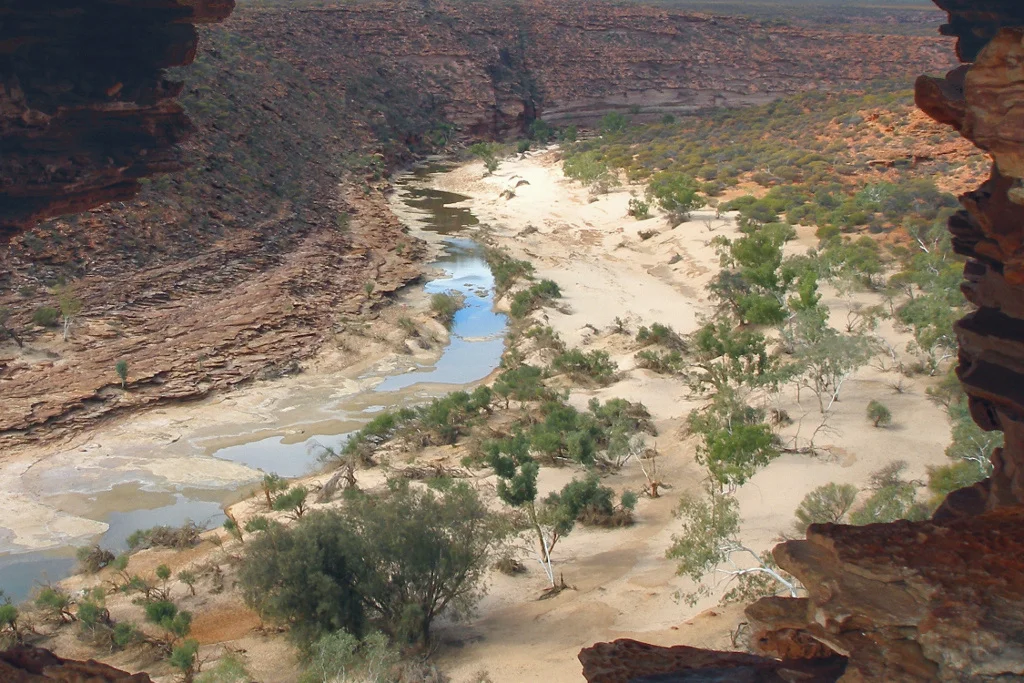
The Murchison is the second-longest river in Western Australia, running roughly 820 kilometres from the inland ranges to the Indian Ocean. Its final act is the most dramatic. Across the lower reaches, the river meanders through nearly eighty kilometres of gorge, slicing down through layered sandstone to expose bands of deep rust and pale cream stacked like the pages of a closed book. The most photographed spot is Nature's Window, a hole weathered clean through a fin of rock that frames a bend in the river below. A one-kilometre track leads out to it, and travellers queue to stand inside the opening and look through stone at the water that made it.
Where the Land Meets the Ocean
The park has two faces. Inland lies the gorge country of striped Tumblagooda sandstone, hot and silent. To the west, the park guards a stretch of coast south of Kalbarri town where cliffs rise more than a hundred metres straight out of the surf. Wind and sea have whittled the headlands into named shapes - Mushroom Rock, the sea stack called Island Rock, and the wave-bored arch of the Natural Bridge. Between them, pocket beaches like Pot Alley and Red Bluff drop down to water the colour of bottle glass, where people swim, snorkel and surf beneath the cliffs.
Eight Hundred Kinds of Bloom
For much of the year the country reads as dry scrub. Then, from late winter into early summer, it detonates into colour. The Kalbarri area carries more than eight hundred species of wildflower, and twenty-one of them grow nowhere on Earth but these cliff tops and gorges. Feather-flowers, banksias, kangaroo paw and starbursts of everlastings carpet ground that looked dead a month before. The wildlife is harder to spot but no less present: emus stalking the spinifex, ospreys and wedge-tailed eagles riding the cliff thermals, and the armoured little thorny devil picking ants from the sand one at a time.
Scars and Survival
Nature here does not only build slowly; sometimes it tears through. In April 2021, Cyclone Seroja crossed the coast as a severe Category 3 storm just south of Kalbarri, with gusts near 170 kilometres an hour. It was one of the most destructive cyclones to strike this far south in the region's recorded history, and it damaged roughly seventy per cent of the structures in the town below the park. The Skywalk, opened only the year before in June 2020, sits above country that has weathered drought, flood and storm for far longer than any railing has stood there. The park, established in 1963, has no campgrounds or water of its own inside its boundaries - all of that waits in the town - so the gorge stays raw, a place you enter and then leave. The wildflowers returned. The gorge kept its patient pace. And the river, the slow architect of all of it, went on doing what it has done for ages: cutting down, grain by grain, toward the sea.
From the Air
Kalbarri National Park centres near 27.78 degrees south, 114.25 degrees east, on the Mid West coast of Western Australia. From the air the signatures are unmistakable: the dark sinuous slot of the Murchison River gorge cutting inland, and the abrupt line where coastal cliffs meet the Indian Ocean south of Kalbarri town. The Skywalk and Nature's Window sit on the gorge's inland reaches roughly 25-30 km east of town. Light aircraft can use Kalbarri Airport (YKBR / KAX) about 10 km east of town, though it offers no fuel; the main regional field is Geraldton Airport (YGEL), roughly 160 km south. A viewing altitude of 3,000-5,000 ft AGL traces the gorge well in the typically clear, dry skies; expect strong afternoon coastal winds and watch for cyclone-season weather between November and April.
Nearby Stories
- Eurardy Reserve 7.4 km away
- Ajana 10 km away
- Murchison River Gorge 37 km away
- Heirisson Prong 151 km away
- Useless Loop, Western Australia 193 km away
- HMAS Torrens (DE 53) 407 km away
- Perth Basin 440 km away
- Chatham Islands 6343 km away