
Madagascar Spiny Forests
Nineteen out of every twenty plants in this forest live nowhere else on the planet. Walk into the spiny forests of southwestern Madagascar and the strangeness is immediate: spindly trunks studded with thorns reach upward like the arms of some sea creature, leaves shrink to almost nothing, and the whole landscape looks built for a different world. It is a place that took drought and turned it into one of the most distinctive plant communities on Earth, so unusual and so important that it sits among the Global 200, the list of the most ecologically vital regions anywhere.
A Catalogue of Endemics
The numbers behind this forest are staggering. Across the ecoregion, 48 percent of the plant genera and an astonishing 95 percent of the species are endemic, found here and nowhere else, the highest level of plant endemism anywhere in Madagascar. That is what isolation and a harsh climate produce given enough time: a botanical laboratory sealed off from the rest of the world, evolving its own answers to the problem of how to live with too little water. To wander here is to walk through a living archive of solutions you will not find on any other continent. It is one of the 200 most important ecological regions on the planet for exactly this reason: not its size, but the sheer concentration of life that exists here and nowhere else.
Trees That Mimic Cacti
The signature plants belong to a subfamily called the Didiereoideae, woody and thorned and strange. They look so much like cacti that the resemblance fools nearly everyone, yet they are only distant relatives, having arrived at the same spiky design from a completely different branch of the plant family tree. This is convergent evolution made visible, two unrelated lineages reaching the same spiky shape because the same desert posed the same questions. Among them grows the octopus tree, Didierea madagascariensis, its limbs sprawling outward like tentacles, and the tall Alluaudia procera, sometimes called the Madagascar ocotillo for its likeness to yet another desert plant from across the world. Add the baobabs, of which six of the world's eight species grow only on Madagascar, and you have a skyline unlike anywhere else, all swollen trunks and thorned arms reaching into a hard blue sky.
Built for the Dry
Everything here is an adaptation to scarcity. The spiny forest grows on poor, thin soils under a sky that delivers low and unreliable winter rain, so the plants have engineered themselves to survive long thirst. Thorns deter the animals that might eat precious moisture-storing tissue. Tiny leaves, or none at all, cut the water lost to the hot air. Beyond the dramatic Didiereoideae, the forest fills out with members of more familiar plant families, the Burseraceae and Euphorbiaceae, the Anacardiaceae and Fabaceae, all of which have cousins elsewhere but here join a community shaped entirely by drought. The result is a forest that looks less green than gray and silver, beautiful in an austere, otherworldly way.
A Corner of a Divided Island
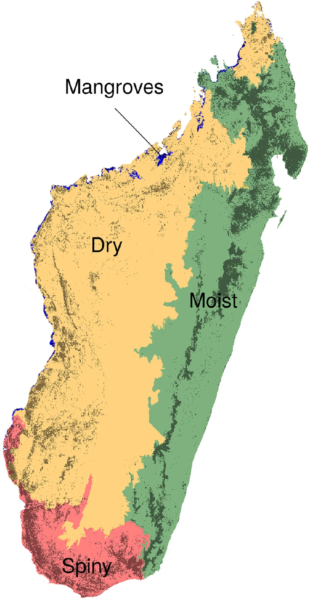
Madagascar can be read like a map of climates, and the spiny forest is its driest chapter. The great island divides into four broad zones: lush moist forest along the eastern flank, dry forest in the west, mangroves fringing the western coast, and this spiny forest claiming the parched south. Each is a world unto itself, but the southern thickets feel the most extreme, a place where the conditions are harshest and the plants most singular. It is precisely that harshness that makes this corner so precious. A landscape that asks so much of life produces life found nowhere else, which is exactly why conservationists count it among the regions the world cannot afford to lose.
From the Air
The Madagascar spiny forests spread across the island's arid southwest, centered near 24.90 degrees S, 44.20 degrees E. From 4,000 to 9,000 feet the terrain reads as pale, low scrub stretching inland from the coast, distinct from the greener forests to the north and east, often broken by the bottle-shaped silhouettes of baobabs. Toliara Airport (FMST) on the southwest coast is the most useful gateway, with Tolanaro (Fort Dauphin) Airport (FMSD) serving the southeastern edge of the region. The dry season from April to October offers the clearest flying and the starkest view of this silver-gray landscape.
Nearby Stories
- Tsimanampetsotsa National Park 63 km away
- Androy 66 km away
- Anosy 177 km away
- Mikea Forest 224 km away
- Velondriake 314 km away
- Inhaca Island 1072 km away
- Ponta d'Ouro 1138 km away
- Ngilgi Cave 6757 km away