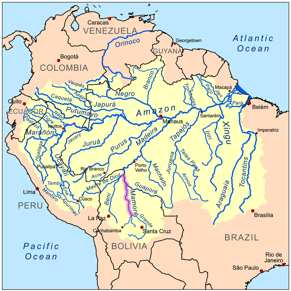

Mamoré River
Follow the water far enough and the Amazon begins in surprising places. One of its great feeder-rivers, the Mamoré, gathers itself on the northern slopes above Cochabamba in the Bolivian highlands, then runs north for hundreds of kilometers across flat, flooding plains before joining the Beni and Madre de Dios to form the Madeira, one of the mightiest tributaries of the Amazon itself. Along the way it passes through country that has held a lost civilization, fueled a fortune in rubber, and swallowed thousands of lives in one of the deadliest railway projects ever attempted. For a river most of the world has never heard of, the Mamoré has carried an extraordinary amount of history on its current.
A River Assembled from Many
The Mamoré is less a single stream than a gathering of them. It rises high in the Sierra de Cochabamba, where it is first called the Chimoré, and collects tributary after tributary as it descends: the Chapare, Secure, Apere, and Yacuma feeding in from the west, the Ichilo, Guapay, and Guaporé from the east. Some of these rivals nearly outmatch their parent. The Guapay is actually longer, but runs shallow and obstructed; the Guaporé rivals the Mamoré in both length and flow, rising on the Parecis plateau in Brazil so close to other watersheds that nearby streams run off toward the distant Paraguay and Paraná in the opposite direction. Over much of its course the Mamoré is broad and navigable, a working highway through a region where roads have always been an afterthought.
The Plain That Hid a Civilization
Spread across the river's basin is the Llanos de Moxos, a vast seasonally flooded plain in northeastern Bolivia that for centuries looked, to outside eyes, like empty wetland. It was anything but. Beginning around 1,500 years ago, the people archaeologists now call the Casarabe culture engineered this landscape on a monumental scale, raising earthen mounds for their settlements, cutting canals and causeways, and building raised fields to farm ground that drowned every wet season. Only in recent decades, with aerial and laser surveys, has the scale come fully into view: a dense, interconnected society thriving in the Amazon long before Europeans arrived. The Mamoré and its tributaries were the arteries of that world.
The Devil's Railway
By the late nineteenth century, a different kind of wealth ran through these forests: rubber. The trouble was the rapids. Where the Mamoré joins the Beni and becomes the Madeira, a long stretch of cataracts blocked boats from reaching the Atlantic. The answer was the Madeira-Mamoré Railroad, built between 1907 and 1912 to skirt the rapids, after Bolivia ceded the rubber-rich territory of Acre to Brazil in exchange for the rail link. The cost was horrifying. Workers came from around the world and died in their thousands from malaria, yellow fever, and accidents in the jungle. At least 3,600 men perished, and by some accounts far more, earning it the name the Devil's Railway. It was finished just as cheaper Asian rubber collapsed the boom, and the line eventually fell silent in 1972.
The Long Quiet River
Today the Mamoré flows much as it always has, wide and brown and unhurried across the Bolivian lowlands, swelling enormously in the rains and shrinking back in the dry season. Measurements taken as far back as 1874 by the engineer Franz Keller recorded its drainage basin at nearly 24,300 square kilometers even without counting the Guaporé. River boats still move people and goods along it, just as they did in the rubber years, and pink river dolphins surface in its slower bends. The booms have faded and the Devil's Railway is a ghost in the trees, but the river endures, still feeding the Amazon, still draining a plain that once held a civilization the world forgot.
From the Air
The Mamoré River winds through the lowlands of central and northern Bolivia along the Brazilian border, with this reference point at roughly 15.94 degrees south, 64.76 degrees west in the Beni floodplain. From the air it appears as a broad, looping, coffee-colored river curling through flat green country dotted with oxbow lakes and seasonal wetlands; in the rainy season the surrounding plains shimmer with standing water. The nearest major airport is Trinidad (ICAO SLTR), capital of the Beni Department, a short distance east. La Paz-El Alto (ICAO SLLP) lies far to the southwest beyond the Andean wall. Best viewed from 5,000-8,000 feet, where the river's serpentine course and the patchwork of flooded plain are most striking. Expect haze in the dry-season burning months and towering convective clouds in the wet season.
Nearby Stories
- Mojeños 62 km away
- San Ignacio de Moxos 77 km away
- Villa Tunari Massacre 88 km away
- Trinidad, Beni 90 km away
- Carrasco National Park 136 km away
- Amboro National Park 183 km away
- Jesuit Missions of Chiquitos 200 km away
- Chiquitano Dry Forests 261 km away