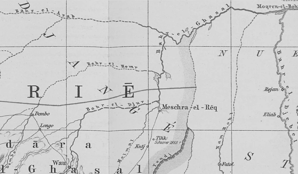
Mechra el Rek
In a country of swamps and rivers without banks, a mechra is a rare thing: an actual place to land a boat. The word is Arabic; the landing it names sits where the Bahr el Ghazal River reaches its dead end just before entering Lake No, in country that the Rek Dinka have long called their own. For centuries Mechra el Rek was the single reliable point of access between the Nile river system and the dry land west of the Sudd. Traders arriving from Khartoum by water had to disembark here. Porters had to be hired here. What happened next, for nineteenth-century commerce in this region, largely depended on what the Rek Dinka were willing to broker, and for a time their willingness was considerable.
A Landing at the End of the Reeds
The geography explains the name. The Bahr el Ghazal River, one of the White Nile's great tributaries, does not so much end as dissolve. Above its entry into Lake No, it runs through vast marshes covered in reeds, the northwestern extension of the Sudd wetlands. Those marshes are not navigable in any straightforward sense; channels shift, papyrus closes over open water, and even experienced pilots can lose their way for days. Mechra el Rek sat at the foot of this labyrinth, the only landing place (hence mechra, the 'crossing' or 'landing') accessible by boat for a very long stretch of river. The Rek Dinka, a major subgroup of the wider Dinka people, occupied the surrounding country. Their willingness to supply porters, food, and information determined whether journeys into the Bahr el Ghazal interior were possible at all.
The Rek and the Ivory Merchants
Most Dinka communities in the mid-nineteenth century were hostile to the Khartoum-based ivory trade, which was intertwined with the slave trade and backed by armed Turko-Egyptian expeditions. The Rek were an exception. They were the first Dinka subgroup to ally themselves with the Khartoum merchants and to supply porters, in a calculated accommodation that brought them trade goods and protection in return for cooperation. It was not a simple relationship. Early in October 1856, the merchant Ali Amouri passed through Mechra el Rek accompanied by a young Nubian named Zobeir, who would later become one of the most powerful slave traders and warlords of the upper Nile. Zobeir returned in October 1858 with his share of the company's profits, about 1,000 Egyptian pounds, a boat, a large quantity of goods, and a body of riflemen. He used Mechra el Rek as his jumping-off point to build a private empire in the Bahr el Ghazal. The Rek who hired themselves out to him were trying to manage a relationship with a much more powerful force; they were not architects of the slave-trading system that grew in their wake.
An Egyptian Province and a Mahdist Crisis
In 1869 Giaffar Mazhar Pasha, governor of the Sudan, sent an expedition south to take official possession of the Bahr el Ghazal, which had effectively been run by ivory and slave traders from Khartoum for years. Mechra el Rek became part of a formal Egyptian-administered province, though the administration was always thin. Two decades later, in October 1894, the region was in crisis again. The Mahdist state that had overthrown the Egyptians in the 1880s was now retreating under British pressure, and its forces were still attacking outposts. The Belgian officer Théodore Nilis, based at Rafaï with 150 to 200 men, was under orders to advance toward Mechra el Rek. A Mahdist offensive threatened his supply lines. His outpost on the Adda River was already short of food. Nilis ordered his defenders back to Rafaï. The hoped-for Belgian presence at Mechra el Rek never materialized.
A Place Rarely Visited
Today Mechra el Rek is a marginal settlement in South Sudan's Warrap State, near the edge of the Sudd. It does not appear on most maps. It is reached most easily, when the wetlands permit, by the same kinds of routes that brought Ali Amouri and Zobeir a century and a half ago. The Rek Dinka who gave the mechra its name still live in the surrounding country, part of a much larger Dinka population that has endured the Turko-Egyptian slave trade, the Mahdist wars, the British colonial period, two Sudanese civil wars, the South Sudanese civil wars, and the intercommunal violence that still breaks out over grazing and water. What remains most striking about Mechra el Rek is how much human history can pivot on a single quiet spot where a boat could tie up, and how little trace that history leaves on the reeds.
From the Air
Mechra el Rek lies at 8.59°N, 29.33°E in Warrap State, near the Bahr el Ghazal River's dissolution into the Sudd wetlands. No significant airport is nearby; Wau Airport (HSWW) to the west and Rumbek Airport (HSMK) to the south are the nearest paved strips. At cruise altitude the Sudd's seasonal wetland pattern is the dominant navigation feature, the Bahr el Ghazal appearing and disappearing as it braids through papyrus. Wet-season flooding from June-October transforms the terrain. Dry-season haze can reduce visibility.
Nearby Stories
- Bahr al-Arab 30 km away
- Block 5A, South Sudan 37 km away
- Abyei 54 km away
- Warrap 65 km away
- Nyal, South Sudan 71 km away
- Bahr el Ghazal (region of South Sudan) 96 km away
- Ruweng Administrative Area 108 km away
- Tonj 132 km away