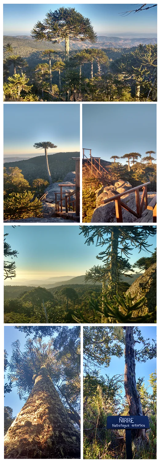

Nahuelbuta National Park
The monkey-puzzle tree looks like something a child drew while imagining what grew before the dinosaurs - and that instinct is almost right. Its branches bristle with razor-sharp, scale-like leaves, arranged so densely that no monkey could climb them, which is how the species got its odd English name. These trees, the araucarias, belong to the high Andes. Yet here at Nahuelbuta they thrive in the Coastal Range, more than a hundred kilometers from the mountains where their cousins live - a stranded, ancient forest standing on a ridge above the Pacific. The name means "big puma" in Mapudungun, and a few of those big cats are said to prowl here still.
Trees Older Than Empires
Some of the araucarias at Nahuelbuta have stood for two thousand years. Let that settle. A tree rooted on this ridge today may have been a sapling when Rome ruled the Mediterranean, and it weathered every Spanish governor, every Mapuche uprising, every Chilean century while barely changing. The Mapuche and their Pehuenche kin revered these trees and lived in part on their pine nuts, the piñones, a harvest that turns the autumn forest into a larder. To walk among them is to feel time stretch - the gnarled, umbrella-crowned giants spaced like sentinels across the high ground, their bark cracked into a pattern that looks almost reptilian.
A Living Ark
Created in 1939 and covering roughly 6,800 hectares, Nahuelbuta protects far more than its signature trees. Beneath the araucarias grow the deep-green coigüe, the southern beeches ñirre and lenga, orchids, and even carnivorous plants that trap insects in the damp understory. The animals are rarer still. The pudú, a deer barely knee-high and one of the smallest in the world, slips through the brush. Somewhere among the roots lives Darwin's fox, a small, dark, gravely endangered canid first described by Charles Darwin himself. Overhead, the Magellanic woodpecker - crow-sized, the male crowned in flaming red - hammers at the old trunks, while the secretive chucao tapaculo calls from the shadows.
The View from Eagle Rock
The park keeps things simple: a network of trails and forest roads, ten campsites with little more than picnic tables and water, open to the public year-round. The most rewarding walk begins at Pehuenco and climbs to Piedra del Águila - Eagle Rock - a granite outcrop at 1,379 meters. From the top, on a clear day, the reward is staggering: the Pacific glinting to the west and the snowcapped wall of the Andes far to the east, with the long valleys of central Chile laid out between. Standing among trees that predate the view's every human story, you grasp why this place feels less like a park than a window into a Chile that almost vanished.
A Survivor Running Out of Time
The araucaria is the national tree of Chile, and biologists call it a living fossil - a lineage older than the Jurassic, kin to trees the dinosaurs walked beneath. It has outlasted unimaginable spans of time. What it may not outlast is us. In 2013 the species was reclassified as Endangered, its forests whittled by logging, grazing, and wildfire; an estimated 200,000 hectares are all that remain on Earth, and climate models warn its habitat could shrink drastically within this century. International trade in the species is now tightly restricted. That is what gives a place like Nahuelbuta its quiet urgency. These groves are not merely scenic. They are a shrinking remnant of deep time, and every protected ridge like this one is part of the reason the trees still stand at all.
From the Air
Nahuelbuta National Park sits atop the Cordillera de Nahuelbuta in the Coastal Range at roughly 37.78°S, 72.98°W, about 162 km northeast of Temuco and 42 km from the town of Angol. From the air, look for the dark, high forest crowning the coastal ridgeline - a band of older-growth green standing well apart from the Andes to the east, with the Pacific shimmering to the west. The high point, Piedra del Águila, reaches 1,379 meters, so a viewing altitude of 5,000 to 8,000 feet gives good clearance and a sweeping coast-to-cordillera panorama. The nearest major airport is La Araucanía International (SCQP) at Temuco to the southeast; Carriel Sur International (SCIE) at Concepción lies to the north. Coastal fog and cloud often shroud the ridge - clear, dry summer afternoons offer the best visibility.
Nearby Stories
- Capitán Pastene 25 km away
- Chivilingo Hydroelectric Plant 38 km away
- Coal Mining in Chile 39 km away
- Santa María Island, Chile 44 km away
- Tucapel 45 km away
- Kingdom of Araucanía and Patagonia 50 km away
- Isla Mocha 59 km away
- Tolhuaca National Park 76 km away