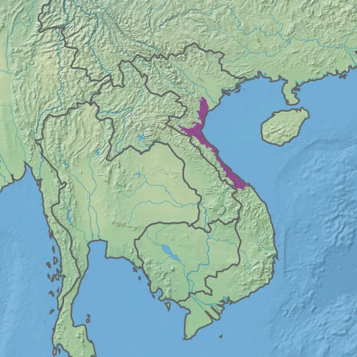

Northern Vietnam Lowland Rain Forests
Average elevation: eighty-eight metres. For a rainforest, that number reads less like a statistic than a verdict. Flat, warm, reliably watered ground is exactly what people farm, and along Vietnam's central-eastern coast they have been farming it for millennia. So the Northern Vietnam lowland rain forests — catalogued by the World Wide Fund for Nature as ecoregion IM0141 — now describe something closer to a memory than a forest. What survives is scattered and defensive: green caught on limestone the plough could not level, ravines too steep to terrace, and a handful of national parks where the biodiversity of an entire coastal plain has been pushed into a corner and told to wait.
Eighty-Eight Metres Above the Sea
The ecoregion runs roughly 380 kilometres from north to south, beginning at the Red River delta and thinning southward to Tam Kỳ, with a spill across the border into adjacent parts of Laos. It averages only about 50 kilometres wide. The Gulf of Tonkin closes it on the east; to the west the land tilts up into the Northern Annamites rain forests, a different world entirely. Elevations reach 1,000 metres at their highest, yet the mean stays down at that startling 88. Geology is what rescues the terrain from flatness. Limestone underlies much of it, and limestone in this climate does not sit still — rain dissolves it into towers, sinkholes and blind valleys, leaving grey rock standing over green paddy like furniture nobody could move. Those karst blocks became accidental arks. Farmland stopped at their feet.
Rain on a Sliding Scale
Every month of the year delivers more than 50 millimetres of rain here. That threshold is the technical reason this counts as wet evergreen forest rather than a seasonal, leaf-dropping one — nothing ever quite dries out, so nothing ever needs to shut down. The totals, though, are unevenly shared along the ribbon. In the north near Hanoi, the year brings around 1,500 millimetres. Travel south toward Huế and the figure doubles to roughly 3,000. The wet season generally runs from September into January, and it arrives with weight rather than drama: low grey ceilings, saturated air, water moving constantly downhill through leaf litter that never fully decomposes. A traveller who expects tropical brilliance in November finds instead a landscape breathing steam.
The Ones That Went Uphill
Where the forest retreated, its animals retreated with it, and the primates tell that story most plainly. The northern white-cheeked gibbon is critically endangered and now found only in northern Vietnam and northern Laos; it was confirmed extinct in China in 2013, its songs simply gone from a country that once held them. Pù Mát National Park protects one of the largest known populations left anywhere. Sharing the same shrinking canopy is the red-shanked douc, a monkey so vividly assembled it looks designed — grey body, white forearms, pale blue eyelids, and maroon-red stockings running knee to ankle. It was classed endangered in 2000, then moved to critically endangered in 2020. Gray langurs persist here too. None of these animals chose the high ground; the low ground was simply taken first.
Four Rooms Left
The ecoregion's surviving biodiversity concentrates in a short list of protected areas, each with its own character. Cúc Phương, at the northern end, was Vietnam's first national park, consecrated in 1962 by Ho Chi Minh himself. Bến En, also in the north, draws visitors for its broad lake, its caves and its walking trails rather than its rarities. Pù Mát sits on the eastern slope of the northern Annamite Range, rugged and remote, with 2,461 plant species confirmed within its boundaries — a figure that hints at how rich the whole coastal plain must once have been. And at the southern end, Bạch Mã climbs steep granite near Huế, straddling the seam where northern and southern Vietnamese plant communities meet and mingle.
Nobody's Villain
It is tempting to narrate a lost forest as a crime, but the people who cleared this one were not conquerors. They were farmers on the most fertile, most accessible, most flood-fed land in the country, feeding one of Southeast Asia's densest rural populations, generation after generation, on ground that happened to be a rainforest first. The result is honest and unsentimental: an ecoregion that now exists mainly as fragments, corridors and reserve boundaries drawn late. What makes the karst towers and the gibbon calls of Pù Mát worth the flight is precisely that they are remnants. You are not looking at wilderness. You are looking at what was left when everything else was needed.
From the Air
Centred near 19.00°N, 105.00°E, the ecoregion forms a narrow coastal band roughly 380 km long and 50 km wide between the Gulf of Tonkin and the Annamite Range. Best viewed at 6,000–10,000 ft, where the pattern reads clearly: rice paddy and settlement across the plain, isolated limestone karst towers and ridges rising abruptly out of it, and the continuous forested wall of the Annamites along the western horizon. Vinh International (VVVH) sits mid-region and makes the natural base; Thọ Xuân (VVTX) serves the northern end near Bến En, Phú Bài (VVPB) the southern end near Bạch Mã, with Đồng Hới (VVDH) between them and Nội Bài (VVNB) at the Red River delta. Expect low ceilings, haze and reduced visibility from September through January during the wet season; February through April generally offers the cleanest air, though morning coastal fog is common.
Nearby Stories
- Diễn Châu 12 km away
- Kim Liên Museum 18 km away
- Ho Chi Minh Trail 18 km away
- Bến En National Park 32 km away
- Ban Nahin 67 km away
- Nghi Sơn Refinery 90 km away
- Viengxay Caves 120 km away
- Battle of Lima Site 85 169 km away