
Ocracoke, North Carolina
Just after sunrise on November 22, 1718, the pirate Edward Teach - known to history as Blackbeard - died on the deck of his sloop in a fierce, close-quarters fight off Ocracoke Island. Lieutenant Robert Maynard of the Royal Navy, dispatched by Virginia's governor with two small sloops to hunt the pirate down, boarded Blackbeard's ship after deliberately playing dead below decks to lure the boarders close. The fight was brutal. Blackbeard took five gunshots and twenty sword cuts before he fell. Maynard cut off his head, hung it from the bowsprit, and sailed back to Virginia for the bounty. The grounds of what is now Springer's Point Nature Preserve were said to have been Blackbeard's favorite Ocracoke anchorage. Three hundred years later, every other shop in the village sells Jolly Roger flags.
The Name and the Algonquian
The name Ocracoke evolved from the Algonquian word Wokokon or Wococcon, which appears on early maps of the island in the late sixteenth and early seventeenth centuries. The word referred to a Native American settlement and the surrounding territory, but the original Algonquian meaning is now uncertain - the Hatteras or Croatan people who used it had largely disappeared by the mid-eighteenth century, victims of Old World epidemics, displacement, and intermarriage with European settlers. The popular folk etymology - that Blackbeard, waiting impatiently for dawn before his final battle, supposedly cried out "O Crow Cock!" at the rooster crowing on the island - is invented. The Italian explorer Giovanni da Verrazzano described the area in 1524 but could not navigate the shallow inlets. In 1585, Sir Walter Raleigh's ship the Tiger ran aground in Ocracoke Inlet and was forced to land for repairs. The English colony at Roanoke followed, and failed. Permanent European settlement of Ocracoke itself waited until 1750.
Pilots and Schooners
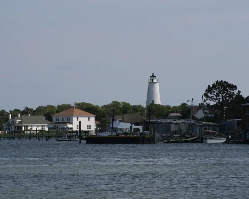
In 1715 the colonial assembly created Pilot Town - a settlement specifically chartered to support the skilled pilots who could thread larger ships through the inlet into Pamlico Sound. Oceangoing vessels carried cargo as far as Ocracoke, then transferred it to smaller schooners that could cross the shallow sound to mainland plantations and river towns. Warehouses lined the harbor. The pilots became wealthy by the rough standards of an island where everything had to come in or out by boat. By the late nineteenth century, the shipping business had moved elsewhere - bigger ships, deeper ports - and the United States Life-Saving Service became the main steady employer for local men. Fishing took over the rest of the economy. The Ocracoke Light, in continuous operation since 1823, is the second-oldest still-active lighthouse in the United States and stands near Silver Lake, the small protected harbor at the heart of the village.
The British Cemetery
During the early months of 1942, German U-boats moved unimpeded along the U.S. East Coast, sinking tankers and merchant ships in such numbers that the period became known to American sailors as the Second Happy Time. Off the North Carolina coast, the wreckage and bodies washed ashore at Ocracoke. Four British sailors from the armed trawler HMT Bedfordshire, which was torpedoed off Cape Lookout on May 11, 1942, with the loss of all hands, were among the dead found on the beach. Local residents buried them on the island. A 2,290-square-foot plot was leased to the Commonwealth War Graves Commission for as long as the land remained a cemetery, a British flag was raised, and it has flown there continuously ever since. The United States Coast Guard station on Ocracoke maintains the graves. Each May, a memorial ceremony brings British naval attachés to this small patch of foreign sovereign soil in the middle of the Outer Banks.
Hoi Toide and Pamlico Brogue
Ocracoke's residents historically speak a distinct dialect of English known as the Hoi Toider brogue - after their pronunciation of "high tide" as "hoi toide." Linguists trace the dialect to seventeenth-century West Country English preserved on the island through more than 250 years of geographic isolation. Until the ferry service modernized in the mid-twentieth century, Ocracoke was effectively unreachable for weeks at a time in bad weather. Younger residents now speak something closer to standard General American, but the older brogue still surfaces in conversation - a vowel here, a phrase there, particularly when locals are talking only among themselves. Linguists have been recording the dialect for decades, knowing it is fading. The North Carolina Language and Life Project at NC State has produced documentaries; tourists arrive specifically to hear it; and the islanders, who know exactly what is happening, sometimes speak more brogue than they otherwise would, as much as performance as preservation.
Storms and Stars
Ocracoke sits in open Atlantic with average elevation less than five feet above sea level, and the weather knows it. Major hurricanes struck in August and September 1933, September 1944, and August 1949 - the first-person accounts of these storms were recorded by survivors on the walls of a Hurricane House that still stands as memorial. Hurricane Dorian in 2019 destroyed roughly 1,000 feet of pavement along NC 12 and closed the island to visitors until contractors could repair the road and dunes; normal access resumed December 5, 2019. The island can only be reached by ferry - one free, from Hatteras across an hour of open water; two toll, from Swan Quarter on the mainland and Cedar Island. Or by private boat. Or by small plane to Ocracoke Island Airport (W95). Because there are no bridges and no major cities for hundreds of miles, the night sky is dark enough that the Milky Way reflects in Silver Lake harbor. The remoteness that makes the storms so dangerous is also what keeps the stars so bright.
From the Air
Located at 35.1128°N, 75.9758°W on Ocracoke Island in the Outer Banks of North Carolina, Hyde County. Ocracoke Island Airport (W95) is a small public airfield southeast of the village - 3,000 ft paved runway, no tower, suitable for light aircraft only. The nearest larger airport is First Flight Airport (KFFA) at Kill Devil Hills, 65 nm north; Hatteras has no public field. Best viewed at 3,500-5,500 feet AGL along the Outer Banks chain, where the village is recognizable as the cluster around Silver Lake harbor with the white tower of Ocracoke Light visible at the southwest end of the island. The long thin shape of Ocracoke Island stretches northeast toward Hatteras Inlet and southwest toward Portsmouth Island.
Nearby Stories
- Oriental, North Carolina 6 km away
- Beaufort, North Carolina 9.8 km away
- Rasmus Midgett 17 km away
- Monitor National Marine Sanctuary 18 km away
- Lake Mattamuskeet 20 km away
- Bath, North Carolina 22 km away
- Crystal Coast 41 km away
- 1916 Charleston Hurricane 916 km away