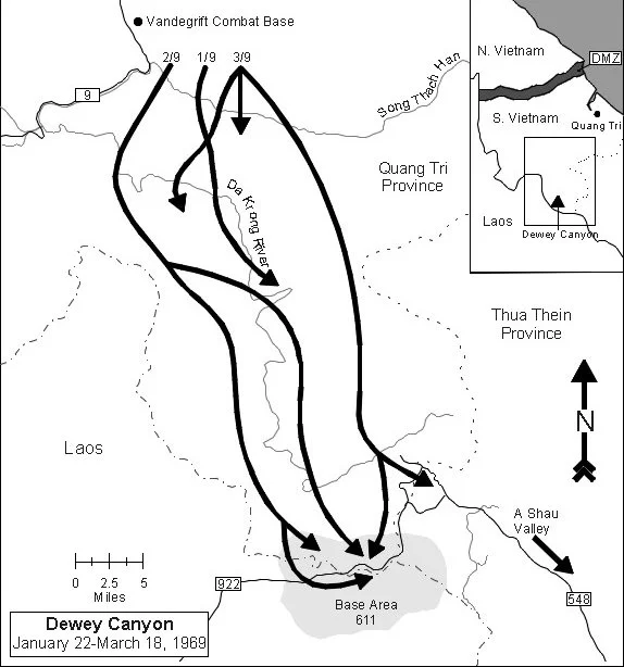

Operation Dewey Canyon
The valleys had been enemy territory for years. North Vietnamese Army forces used the A Shau Valley — 34 kilometers long, pressed close to the Laotian border — as a staging and supply corridor, moving men and materiel south along routes that American units had spent years trying to close. The Marines assigned to the northern I Corps region had spent much of 1967 and 1968 tied to their combat bases, manning defensive positions along what planners called the McNamara Line. When Major General Raymond G. Davis took command of the 3rd Marine Division, he ordered his Marines to leave those bases and go find the enemy. In January 1969, they did.
The McNamara Line and the Shift in Strategy
The McNamara Line — named for Defense Secretary Robert McNamara — was a combination of infantry positions and ground sensors intended to detect and interdict North Vietnamese infiltration across the border and along the Ho Chi Minh Trail. In concept, it was an electronic barrier supplemented by human observation. In practice, the Marines assigned to man it found themselves in static defensive positions, waiting for contact rather than seeking it.
Major General Davis saw this as contrary to everything the Marine Corps stood for. His Marines were trained to attack, to close with the enemy and fight on ground of their own choosing. Tying them to fixed bases surrendered that initiative and handed the enemy the ability to move freely in the intervening terrain. When Davis took command, he changed the approach: units would move out of their bases, push into the valleys the North Vietnamese Army used as supply corridors, and disrupt the logistics chain that fed operations further south. Operation Dewey Canyon was the direct result of that decision.
Into the A Shau
The operation began formally on January 22, 1969, though preliminary movements had started days earlier. The 9th Marine Regiment helicoptered its battalions from Vandegrift Combat Base to a series of firebases in the hills above the valleys — Firebase Henderson, Firebase Tun Tavern, Firebase Shiloh — and began pushing deeper into terrain that North Vietnamese Army units had controlled without serious challenge for years. The A Shau Valley was just 10 kilometers east of the Laotian border, and intelligence suggested a significant North Vietnamese buildup in both the A Shau and the adjacent Đa Krông Valley to the east.
The fighting in those mountains was brutal. The terrain favored defenders; the vegetation — dense, triple-canopy jungle on steep slopes — reduced visibility and complicated both movement and resupply. For 56 days, Marine rifle companies moved through valleys and ridgelines, making contact repeatedly with North Vietnamese Army forces who had established supply caches, base areas, and route networks that they defended seriously. The Marines won the firefights. They captured weapons, destroyed supplies, and killed a documented number of enemy soldiers. The 9th Marine Regiment and attached units were awarded the Army Presidential Unit Citation for the operation.
Across the Border
By late February, elements of the 9th Marines had pushed to within 1,000 meters of the South Vietnamese border with Laos — and then, in a move that would remain politically sensitive for years, crossed it. Operations in Laos were not authorized under the rules of engagement that governed American forces in Vietnam, and the decision to cross was made in the context of pursuing enemy forces who were actively using Laotian territory as sanctuary.
The Marines who fought in Laos were rotated back to Vandegrift Combat Base by March 3, officially ending their operations across the border. Eight Marines from the 2nd Battalion died during the Laotian phase; 33 were wounded. For the official record, all casualties were listed as having occurred in Quảng Trị Province, South Vietnam. No reference was made to Laos in the documentation. The political reasoning was clear: acknowledging ground operations in a nominally neutral country would have widened the war's legal and diplomatic complications. The men who died there were recorded as having died somewhere they had not been.
Valor and Concealment
The contradictions of Operation Dewey Canyon cut in multiple directions. The operation produced extraordinary acts of courage: four Marines received the Medal of Honor, six earned Navy Crosses, and 55 received Silver Stars during the 56-day campaign. These were not token recognitions. The fighting was real, the terrain was punishing, and the men who earned those decorations did so at genuine cost.
At the same time, the deaths in Laos were officially attributed to a province where those Marines were not present. The families of the eight men killed across the border received condolence letters that described events that hadn't happened. This kind of bureaucratic concealment — common practice in a war where the legal boundaries were perpetually contested — was one of the things that eventually broke faith between the American military and the public it reported to.
After the Valleys
Operation Dewey Canyon ended on March 18, 1969. Its commanders assessed it as a tactical success: significant North Vietnamese Army forces had been disrupted, supply caches destroyed, and the valleys swept clean — at least temporarily. But as the after-action reports acknowledged, 56 days of fighting did not stop the overall flow of North Vietnamese troops and supplies into South Vietnam. The Ho Chi Minh Trail had other branches. The valleys refilled.
In April 1971, veterans of the actual operation watched from a distance as the Vietnam Veterans Against the War organized a protest demonstration in Washington, D.C., and named it Operation Dewey Canyon III. The veterans who came to Washington that week brought their medals and threw them over a fence toward the Capitol steps. The name they borrowed honored what they had done and simultaneously made a demand: that the country account honestly for what it had asked them to do, where it had sent them, and what it had written in the records afterward.
From the Air
The operation's main theater centered on approximately 16.57°N, 106.94°E in the rugged mountain terrain of what is now Quảng Trị Province, western Vietnam, near the Laotian border. The A Shau Valley runs roughly north-south for 34 kilometers, oriented along the mountainous border terrain. From altitude, the valley appears as a narrow corridor pressed between steep ridgelines — the kind of terrain where air support was essential but difficult to deliver accurately through the canopy. Vandegrift Combat Base (the staging point for the operation) was located near Cam Lộ, southwest of Đông Hà. Nearest modern airports: Đông Hà has no commercial service; the nearest is Phu Bai International (VVPB) near Huế, approximately 60 kilometers to the southeast. The Laotian border is visible from altitude as a ridge-defined line to the west, approximately 10 kilometers from the valley floor where the Marines operated. Flying west from Huế at 10,000 feet, the terrain rises abruptly into the Truong Son Mountains — steep, forested, and formidable-looking even from a comfortable altitude.
Nearby Stories
- Vietnam's Green Corridor 1.7 km away
- Tam Giang–Cau Hai Lagoon 8.1 km away
- Battle of Cua Viet 14 km away
- Battle of Hamburger Hill 17 km away
- Southern Laos 54 km away
- Grès supérieurs Formation 57 km away
- Saravan 85 km away
- Bach Long Vi Island 362 km away