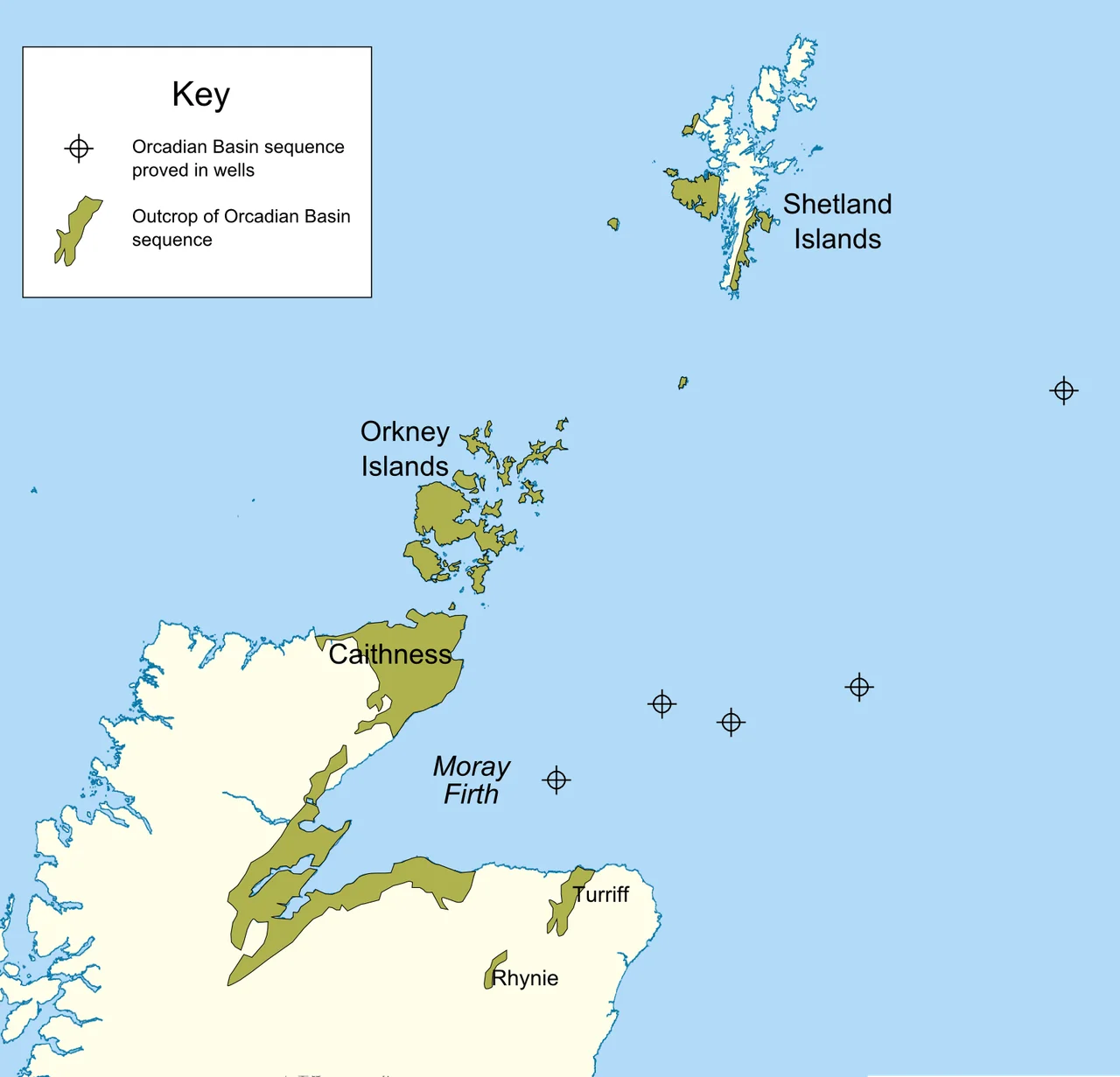

Orcadian Basin
Four hundred million years ago, before there were Orkneys, before there was a North Sea, a great freshwater lake spread across what is now northeastern Scotland. Geologists call it Lake Orcadie. At its deepest interval, the lake covered at least 50,000 square kilometers and plunged to depths of 100 metres or more. Fish swam at its surface, sank through anoxic gloom at the bottom, and were sealed into mud that would harden into flagstone. Drift north today from the Moray Firth toward Shetland and you are flying above the buried floor of that vanished sea.
A Lake the Size of a Country
The Orcadian Basin formed in the Devonian period, after the great Caledonian mountain-building event that crumpled Scotland against Greenland and Scandinavia. As the crust cooled and stretched, fault blocks dropped and filled with sediment. Rivers fed the depression. Eventually a lake formed, expanded, and at its peak inundated almost everything from the south coast of the Moray Firth to Shetland, and from the Caithness coast out under what is now the central North Sea. Hydrocarbon wells far from any visible shore have struck its sediments. The lake's depth and reach were governed by Milankovitch cycles, the slow wobbles of Earth's orbit that drive ice ages and droughts. Every cycle layered the basin with another sheet of mud and silt.
The Achanarras Window
Of all the layers in the basin, one stands out: the Achanarras Fish Bed Member. Deep, anoxic, and stable for an unusually long stretch of geological time, the Achanarras lake preserved fish in extraordinary detail. The quarry near Thurso, in Caithness, has yielded specimens of every major Devonian fish group then alive - armored placoderms, spiny acanthodians, early ray-finned actinopterygians, and the lobe-finned fish whose descendants would eventually crawl onto land. A fish that died near the lake edge could drift toward the center, sink through oxygen-starved water, and be entombed without a scavenger to disturb it. The result is a window into a moment when vertebrate life was experimenting with shapes that no longer exist.
Flagstones for Neolithic Hands
When the lake dried and the millennia rolled on, its mudstones and siltstones hardened into thinly bedded flagstone that splits clean along the bedding. Neolithic builders on Orkney noticed. The walls of Skara Brae, the great chambered tomb of Maes Howe, the Ring of Brodgar, and the Standing Stones of Stenness were all raised from Orcadian flagstone. Five thousand years later, Caithness flagstones became an industrial export, shipped from quarries around Thurso to pave streets in London and far beyond. The Devonian lakebed is still being worked today, though in smaller quantities. The fish that sank in Lake Orcadie helped pave the modern world.
Oil Below, Hills Above
The same organic-rich shales that preserved Achanarras fish also acted as petroleum source rock. The Beatrice oilfield in the Inner Moray Firth produces hydrocarbons that began as Devonian algae and bacteria, cooked over hundreds of millions of years. The visible Orkney and Shetland landscape, with its rounded hills and weathered red sandstone cliffs, is the Orcadian Basin's surviving outcrop. The great cliffs of Hoy and the layered headlands of Caithness expose the same flagstones that lie thousands of feet down beneath the North Sea. The basin connects the prehistoric to the petrochemical in a single rock sequence.
The View from Above
From cruising altitude over the northern North Sea, the basin is invisible - just water, oil platforms, and the green smudges of Orkney and Shetland. But geology shapes everything you see. The Great Glen Fault, running from Inverness to the Moray Firth, passes through what was once the lake's center, then reactivates again and again across millions of years. The Walls Boundary Fault on Shetland is the same structure, displaced. The islands themselves are uplifted fragments of the basin's edge. What looks like Atlantic frontier is actually a geological theatre, with the same play running for 400 million years and counting.
From the Air
Coordinates 59.0 N, 1.5 W places the basin's heart over the northern North Sea between Caithness and Shetland. Cruise at FL340-FL380 for the Aberdeen-Sumburgh corridor; the route passes directly over buried Orcadian sediments and active oil platforms. Nearby airports: Sumburgh (EGPB) on Shetland, Kirkwall (EGPA) on Orkney, Wick (EGPC) and Aberdeen (EGPD) on the mainland. Visibility is often poor and winds notoriously fierce; visual references are the Orkney and Shetland archipelagos and the bright spider-web of North Sea production platforms.
Nearby Stories
- HMS Daring (H16) 13 km away
- Fair Isle 33 km away
- Copinsay 34 km away
- HMS Sword Dance (1918) 44 km away
- Piper Alpha 81 km away
- 1982 Bristow Helicopters Bell 212 Crash 311 km away
- Alexander L. Kielland (Platform) 373 km away
- The Laki Eruption: The Volcano That Changed World History 1002 km away