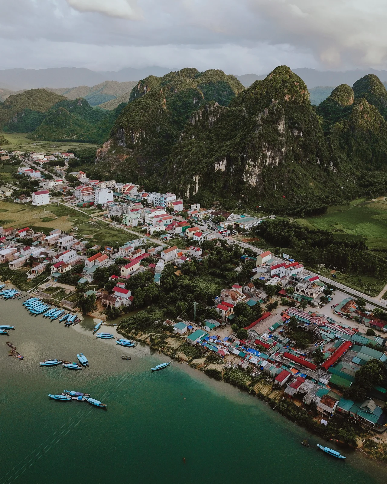

Phong Nha
Boats go into Phong Nha Cave all day now, engines cut at the entrance so the last stretch is done on oars, and the sound the passengers make is always the same — the involuntary noise people make when a ceiling turns out to be much further away than expected. Sixty years ago the same mouth was used for something else. Vehicles crossing the Sơn River at the Xuân Sơn ferry moved only after dark, and by daylight they were driven or towed into the cave and hidden there, because American aircraft could not bomb what they could not see. The river, the ferry crossing and the cave were a single working piece of the Hồ Chí Minh trail. The village outside is called Phong Nha, and it has spent the last half-century becoming something entirely different.
Four Villages on a Limestone River
People settled this stretch of the Sơn valley a long time before anybody thought to sell tickets. Four villages — Cù Lạc, Phong Nha, Gia Tịnh and Xuân Sơn — formed here between roughly the fourteenth and sixteenth centuries, and under the Nguyễn dynasty they were administered together as part of Cao Lao commune in Bố Trạch district. It is good country for a village and difficult country for anything larger: a narrow ribbon of alluvium along the river, hemmed by the grey limestone of the Kẻ Bàng massif, with rolling hills behind. After the August Revolution the area was consolidated as Sơn Trạch commune, and in June 1955 Sơn Trạch was split into four. Farming was the living. It stayed the living for a very long time.
The Ferry at Xuân Sơn
During the 1960s the war arrived and reorganised everything around the river crossing. Xuân Sơn was where men, weapons and vehicles headed for the trail got over the Sơn, and the work was done at night by people who understood exactly what would happen if the crossing were spotted. Equipment was moved into the mouth of Phong Nha Cave before dawn and brought out again after dark. Bombing was continuous in this province and a river crossing is an obvious target; keeping it open was dangerous work done largely by local people, and the villages nearby lived with the consequences of a supply line running through their fields. Vietnam recognised Xuân Sơn ferry as a national special historical site in 2013. The visitors who queue at the same landing stage today are mostly unaware they are standing on it.
The Settlement That Took the Cave's Name
For most of the modern era this place was called Sơn Trạch, and the cave was a feature within it. Then the balance inverted. Phong Nha–Kẻ Bàng was inscribed by UNESCO in 2003, the tourism that followed attached itself to the cave's name rather than the commune's, and on 10 January 2020, by Resolution 862/NQ-UBTVQH14, Sơn Trạch commune was converted whole into a township and renamed Phong Nha, after the cave. It is not often that a town takes its name from a hole in a mountain, but the economics were unarguable: by 2020 the cave was the reason anybody outside Quảng Bình had heard of the place at all.
Farming, and the Other Thing
The commune is the service centre for the entire national park, and the list of what visitors come for now runs well past the original cave: Tiên Sơn in the hills above it, the Moọc water spring, the Chày River and the Dark Cave. Guesthouses, boat crews, guides, porters and drivers have grown up around all of it, layered onto an economy that is still substantially agricultural. Both halves matter. Tourism here is highly seasonal, sensitive to weather and to events on the other side of the world, and the rice and the livestock are what remain when the boats stop running. It is also worth saying plainly what the change involved: a generation whose parents took their income out of the forest — timber, agarwood, wildlife — now largely takes it from people who come to look at the forest instead.
Everything Renamed at Once
In the summer of 2025 Vietnam rebuilt its local government from the ground up, and Phong Nha was reorganised twice inside three weeks. On 12 June, Quảng Bình province was dissolved and merged into Quảng Trị, the enlarged province keeping the southern name and taking Đồng Hới as its capital. Then, on 1 July, Phong Nha township was combined with the communes of Lâm Trạch, Xuân Trạch and Phúc Trạch under Resolution 1680/NQ-UBTVQH15 to form a single new Phong Nha commune: 358.1 square kilometres, a little over 39,000 people, and a boundary that now takes in a serious portion of the karst itself. In five years the place has gone from a rural commune, to a township, to a commune again, and moved provinces without anyone leaving home. The cave has not moved at all.
From the Air
17.612°N, 106.305°E, on the Sơn River at the eastern edge of Phong Nha–Kẻ Bàng National Park in Quảng Trị province (formerly Quảng Bình, merged June 2025), about 40 km northwest of Đồng Hới. Best viewed from 3,000–7,000 ft, low enough to separate the settlement from the karst behind it. Visual references: the Sơn River emerging from the limestone and running east in wide pale meanders, the built-up strip along its north bank, the Hồ Chí Minh Highway crossing just downstream, and the abrupt front of grey conical karst towers rising immediately west where the cave entrances lie. The old Khe Gát airstrip alignment sits a short distance north. Nearest airport is Đồng Hới (VVDH), 40 km southeast, with Huế/Phú Bài (VVPB) around 190 km south. Expect low morning cloud against the karst most of the year, sustained heavy rain and river flooding from October into December, and the clearest air from February through April.
Nearby Stories
- Mụ Giạ Pass 3.9 km away
- Hoành Sơn Range 6.9 km away
- Ban Karai Pass: The Gap They Could Not Close 17 km away
- Hien Luong Bridge 48 km away
- Arem language 58 km away
- National Route 9 (Vietnam) 86 km away
- DMZ (Vietnam) 89 km away
- Bach Long Vi Island 261 km away