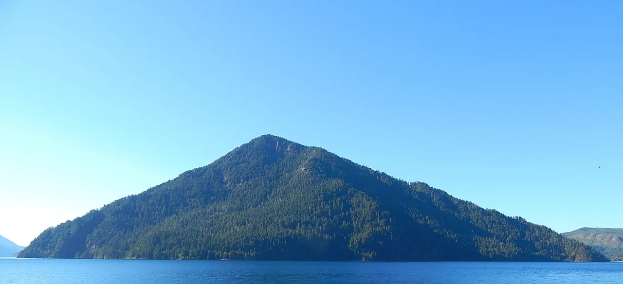

Pyramid Mountain (Clallam County, Washington)
Somebody had to carry the lumber. In the fall of 1942, with the Pacific war less than a year old and the Washington coast braced for an attack that never came, two National Park Service employees named Joe and Rena Shurnick hauled boards and shingles up the steep flank of a 3,100-foot peak above Lake Crescent and put together a shed. Thirteen feet by sixteen. Wood shingles on the walls, shakes on a simple pitched roof, windows facing every direction. From that one small room, watchers were supposed to scan the sky over the Olympic Peninsula and report anything with wings. The Army paid for it. The building is still up there.
Watching an Empty Sky
The Aircraft Warning Service was, in practice, a national volunteer effort: ordinary people posted on hilltops, rooftops and headlands with binoculars, a telephone line and a set of aircraft silhouettes. Radar was young, coverage was thin, and the West Coast in 1942 genuinely did not know what might appear offshore. Thirteen such stations went up within the boundaries of what is now Olympic National Park. Pyramid's watchers held their post until June 1944, when the service was wound down and the whole apparatus of amateur sky-watching quietly dissolved. Nothing ever came. That is the point of the place, really - a structure built entirely out of uncertainty, staffed through two winters of Olympic weather on the chance that the uncertainty would resolve badly. Two of those Olympic stations survive today. The Pyramid Peak lookout is one; Dodger Point is the other. It joined the National Register of Historic Places on 13 July 2007.
The Lake That Was Split
Look down from the summit and the geology explains itself. A vast landslide scar runs across the slope below, and where it reaches the valley floor it has plugged the drainage entirely. Roughly eight thousand years ago that slide came down, choked Indian Creek, and cut the valley in two. On one side of the debris sits Lake Crescent, long and bent and startlingly deep; on the other, Lake Sutherland, with Indian Creek running on down toward the Elwha River. The S'Klallam and Quileute peoples tell of a fight between two groups that so angered Mount Storm King that the mountain broke off a piece of his own head and threw it down on the combatants, ending the battle and dividing the water. The slide is right there in front of you, the mountain is right there to the east, and the two accounts are describing the same afternoon. Cut off from the sea, the trout in Lake Crescent went their own way and became something found nowhere else - the Beardslee, among the largest landlocked rainbows anywhere in their native range.
Sugarloaf, Renamed
For years this peak was Sugarloaf Mountain, a name people all over North America gave to any hill shaped like the cones of refined sugar sold in shops. In 1928 it became Pyramid, which is not a better name so much as a more geometric one. Either way the mountain earns it from below: from Barnes Point and the lawn at Lake Crescent Lodge, it is the sharp green wedge that closes off the view up the lake. Getting to the top takes about three and a half miles of trail and roughly 2,750 feet of climbing, beginning in dense forest and opening out as the grade steepens. Partway up, the path crosses the exposed face of a slide - a football-field width of loose ground where the tread narrows to a foot or two, with a long drop below and nothing much to hold. Hikers remember that stretch more clearly than the summit.
Where the Weather Lands First
Storms here arrive from the west with nothing in their way. Fronts form over the Pacific, run northeast, and hit the Olympic wall, where the peaks force them upward until they let go of their moisture as rain or, in winter, as snow. It is the same mechanism that makes the western Olympics one of the wettest places in the contiguous United States, and it means the summit spends much of the year inside cloud. When a front passes and the air scours clean, the payoff is enormous: the whole crescent of the lake below, the Strait of Juan de Fuca beyond it, and far to the east across Puget Sound, the white cone of Mount Baker standing clear in the Cascades. The Pleistocene did the carving - glaciers advancing and retreating over and over, grinding the ridgelines into the shapes now visible. The watchers of 1942 had the best seat in the Olympics, and hoped to see nothing at all.
From the Air
Pyramid Mountain rises to about 3,100 feet at 48.0748 N, 123.8070 W, on the north shore of Lake Crescent in Olympic National Park, Clallam County, Washington. The unmistakable visual anchor is Lake Crescent itself - a long, sharply bent ribbon of deep blue water roughly 8 nm southwest of the Strait of Juan de Fuca shoreline, with US 101 tracing its southern edge. The peak is the pointed summit standing over the lake's outer bend; the pale landslide scar below the summit and the flat plug separating Lake Crescent from Lake Sutherland to the east are both visible from the air. A viewing altitude of 5,500 to 7,500 feet MSL gives good perspective on the lake, the slide and the surrounding Olympic ridgelines while staying clear of the higher terrain rising to the south toward Mount Olympus. Nearest field is William R. Fairchild International Airport at Port Angeles (KCLM), about 18 nm east; Victoria International (CYYJ) lies across the strait to the northeast, and Sekiu (11S) sits to the west near the coast. Marine cloud and orographic lift make low ceilings common on the north-facing slopes; the clearest conditions usually follow a passing front, when Mount Baker becomes visible across Puget Sound.
Nearby Stories
- Sheringham Point Light 4.1 km away
- Ogden Point 8.4 km away
- Makah Museum 11 km away
- Ozette Lake 13 km away
- Destruction Island 16 km away
- Hurricane Ridge 17 km away
- Olympic: Where Rainforest Meets the Wild Pacific 24 km away
- United States Naval Undersea Museum 59 km away
Sources
- Pyramid Mountain (Clallam County, Washington)
- Pyramid Peak Aircraft Warning Service Lookout - Wikipedia
- Pyramid Mountain / Pyramid Peak - Washington Trails Association and SummitPost
- Lake Crescent geology, Mount Storm King and the Beardslee trout
- Pyramid Mountain / Lake Crescent - Washington Trails Association hike page
- Pyramid Mountain (Clallam County, Washington) - Wikipedia