
Race Rocks Ecological Reserve
Most protected areas begin with a government. This one began with a school project. In 1978, students at Pearson College UWC on the Vancouver Island shore went out to a cluster of rocks in the Strait of Juan de Fuca to survey what lived there, under the supervision of two of their teachers, Garry Fletcher and Marks McAvity. What they documented was not an ordinary stretch of coastline but an extraordinary concentration of life, crowded onto a few hectares of rock and kept fed by a tide that never really stops moving. Two years later, the province made it a reserve.
Eleven Islets in a Current
Race Rocks lies 1.5 kilometres off the southern tip of Vancouver Island, at a pinch point in the Strait of Juan de Fuca where enormous volumes of Pacific water are forced through a narrowing channel twice a day in each direction. The reserve covers 2.27 square kilometres, of which barely 0.02 square kilometres is actually land - eleven islets, most of them low enough to wear a green fringe of algae and little else. The rest is water, and the water is the point. Where currents run hard, they carry nutrients and oxygen past everything anchored to the bottom, and everything anchored to the bottom takes advantage. The result is a density of marine invertebrates, algae, sea grass and fish that divers travel a long way to see.
Granite Shipped From Scotland
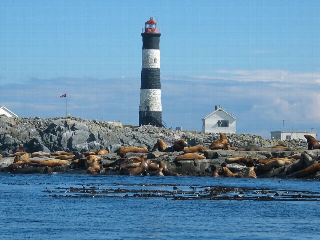
One structure predates every protection order here. The Race Rocks lighthouse went up between 1859 and 1860, built by the crew of HMS Topaze alongside hired labourers under a contract the British government awarded to John Morris. It was lit on 26 December 1860, six weeks after Fisgard Island - making these two the first lighthouses on Canada's west coast. Race Rocks is the only one on that coast built of rock: granite said to have been quarried in Scotland, topped with sandstone from Gabriola Island. The 24.4-metre tower carries black and white bands you can pick out from a long way off, flashes white every ten seconds, and answers fog with three blasts a minute apart. The light was automated in 1997, and Pearson College UWC took over running the station.
Standing Room Only
Haul-outs are competitive real estate, and Race Rocks is prime. California sea lions and Steller sea lions pile onto the rocks in numbers that make the islets look upholstered, roaring and shoving and sliding back into the water. Harbour seals use the reserve as a birthing rookery. So, remarkably, do northern elephant seals - this is the most northerly birthing colony for the species anywhere on the Pacific coast of North America, an animal more associated with California beaches raising pups within sight of Vancouver Island. Seabirds work the turbulence overhead. The whole assembly runs on the same engine: a tidal current that keeps the water column stirred and the food arriving on schedule.
Managed By a High School
The 1978 survey by the Pearson College students did what good fieldwork is supposed to do - it produced an argument that could not be ignored. In 1980 the rocks and the water around them were protected as an ecological reserve, and the arrangement that followed is unusual anywhere in the world: joint management between BC Parks and the college. Students have been part of the monitoring ever since. Excluded from the reserve boundary is a small envelope of land on Great Race Rock holding the lighthouse and the foghorn, leased by the Canadian Coast Guard - a reminder that the oldest business conducted out here, keeping ships off these rocks, is still being conducted.
Trying to Harvest the Tide
A current that strong is an obvious temptation to engineers, and in 2006 and 2007 the Race Rocks Tidal Power Demonstration Project put a tidal energy generator into the water to find out what it could do. It ran as an experiment for six years, gathering data on a form of generation that is predictable in a way wind and sun are not - the tide arrives on a published schedule. Then the generator was removed. What it leaves behind is a set of numbers and a fairly hard-won piece of knowledge about how difficult it is to build machinery that can live permanently in moving salt water. The tide, unbothered, carried on.
From the Air
Race Rocks sits at 48.299°N, 123.531°W, roughly 1.5 km off the southern tip of Vancouver Island in the Strait of Juan de Fuca. The visual cue is the black-and-white banded tower on Great Race Rock, 24.4 m tall and conspicuous against dark water from 1,500-3,000 ft. On a running tide the islets trail visible current lines, tide rips and standing white water downstream - one of the clearest displays of tidal hydraulics visible from the air anywhere on this coast. The Olympic Peninsula fills the horizon to the south across the strait; Victoria and the Esquimalt naval base lie northeast along the shore. Victoria International (CYYJ) is 22 km north-northwest of Victoria in North Saanich, and William R. Fairchild International (KCLM) at Port Angeles sits directly across the strait in Washington. Keep well clear of the wildlife: this is a haul-out and a birthing rookery, and low overflight disturbs it. Expect strong westerlies funnelling up the strait and rapid fog formation in summer.
Nearby Stories
- San Juan Islands National Monument 2.2 km away
- The Malahat: Vancouver Island's Cliff-Hanging Highway 2.4 km away
- Olympic National Park 5.9 km away
- Pysht, Washington 6.3 km away
- San Juan Spruce 10 km away
- Smith Island (Washington) 17 km away
- Quillehuyte County, Washington 21 km away
- United States Naval Undersea Museum 45 km away