Rio Branco, Acre
The Gameleira tree still stands at the bend of the Acre River, a strangler fig with a 2.5-meter trunk and a twenty-meter canopy, older than the city that grew up around it. In the 1880s, workers putting up the first shacks on the riverbank chose that spot because it was easier than clearing the forest. A few years later, the same tree was standing in the middle of the fighting at Volta da Empresa, where Acrean revolutionaries pushed back Bolivian troops during the short, strange war that ended with Acre becoming Brazilian. Rio Branco - capital of the state of Acre, population about 388,000 in 2024 - grew up around a tree that saw both its founding and its independence.
Built on Rubber
The lands where Rio Branco now sits were once home to the Aquiri, Canamari, and Maneteri peoples. The rubber tappers who arrived in the late 19th century were mostly Brazilians - drawn west by the rubber boom, working the hevea trees of what was then technically Bolivian territory. Villa Rio Branco became the main urban center of the Acre valley by August 1904, in the immediate aftermath of the Treaty of Petropolis that made Acre Brazilian. Around the Gameleira tree, the streets filled with bars, cafes, casinos, and the commercial agents of international trading houses moving thousands of contos de reis in rubber transactions. The city was one of the oldest in Brazil's interior - older than Goiania, Belo Horizonte, Brasilia, Palmas, or Boa Vista - and during the boom years it was wealthy in a way that was hard to sustain once synthetic rubber ended the monopoly.
Two Banks of the Same River
Rio Branco sits at 143 meters above sea level, straddling both banks of the Acre River. The political administration was eventually moved to the left bank - higher ground, less prone to flooding - while the original commercial zone on the right bank gradually declined. By the 1930s, Syrian and Lebanese immigrants had given that area a new life; one neighborhood became known as Bairro Beirut. By the 1950s the old commercial core had faded into what locals call the Second District. Today six bridges link the two districts, the newest being the Joaquim Macedo Catwalk, a cable-suspension pedestrian bridge finished in 2006. Rio Branco also has the largest proportional bicycle path network per inhabitant of any Brazilian state capital, a fact the city likes to mention.
Floods and Frosts
The climate is tropical monsoon, and most of the year the weather does what you would expect near nine degrees south: hot, humid, with heavy rain from October through May and a shorter dry season from June to September. Rio Branco has the lowest average annual temperature of any Amazon or Northeast Brazil capital, but lowest here still means daytime highs in the upper twenties. The exceptions are what make the climate interesting. In July 2010, a cold front from the south pushed temperatures to 9.8 degrees Celsius at dawn on the 19th - nearly freezing in a city where 22 degrees is considered cool. And the Acre River, which the city depends on for transport and atmosphere, has many floodplain stretches that submerge the lower neighborhoods when the rains run hard. In March 2023, over 15,000 people were displaced after a single month delivered 585.9 millimeters of rain.
Santo Daime's Home Ground
One of Rio Branco's most unusual landmarks is the tomb of Raimundo Irineu Serra, the rubber tapper from Maranhao who moved to Acre and founded the religion now called Santo Daime. His sepulcher sits in the Alto Santo neighborhood and has become a pilgrimage site for Daimistas around the world. Santo Daime is the religion built around a tea brewed from ayahuasca and chacruna - a sacrament consumed in hours-long ceremonies, wrapped in Catholic hymns and the local cosmology of the forest. Its global reach is small but remarkable, with communities from Amsterdam to Japan tracing their practice back to this quiet corner of the Amazon capital.
Rubber, Brazil Nuts, and What Comes Next
Historically the economy depended on two forest products: natural rubber and brazil nuts. Today wood is the main export of the state of Acre, along with acai fruit, cassava flour, copaiba oil, and beef. Rio Branco is trying to reinvent itself through agribusiness, aquaculture, and ecotourism; Petrobras has suggested the region has potential for future petroleum extraction, though nothing has been developed at scale. The city hosts the Federal University of Acre, the only public university in the state. The airport on BR-364 handles domestic traffic and occasional international flights; the road network connects east to the rest of Brazil and west to Peru via the Interoceanic Highway, which links Rio Branco all the way to Cuzco. It is still a city you have to want to reach - but one that connects, if you follow its roads far enough, two coasts and three languages.
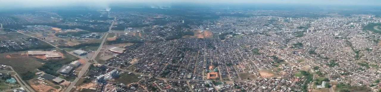
From the Air
Rio Branco sits at 9.98 degrees south, 67.81 degrees west, at an elevation of 143 m. The city spreads along both banks of the meandering Acre River in far western Brazil, surrounded by rainforest and floodplain. Rio Branco-Placido de Castro International Airport (SBRB / RBR), 18 km from the city on the BR-364, is the main aviation gateway. Expect high humidity and frequent heavy convective buildups, especially during the October-May wet season; the dry-season phenomenon called friagem can bring unusually cool southern air for a few days at a time.
Nearby Stories
- Placido de Castro, Acre 58 km away
- Acre River 108 km away
- Aerocon Flight 25 150 km away
- Cachuela Esperanza 183 km away
- Rio Vermelho State Forest 237 km away
- Tambopata National Reserve 325 km away
- Eirunepé 382 km away
- Manu National Park 450 km away