Eirunepé
Measured in straight lines, Eirunepé sits 1,150 kilometers from Manaus. Measured the way people actually travel here - by river - it's 2,417 kilometers, following the Amazon west to the mouth of the Juruá and then south through one of the largest meandering river systems on Earth. Few Brazilian cities are this far from their state capital. The town sits on the left bank of the Juruá just above where the Tarauacá flows in from the opposite shore, and it was built on the headquarters of a single rubber plantation called Eiru. The plantation's owner wanted authorities nearby. He wrote letters to the government. Eventually, through a century of name changes and legal reorganizations, the settlement became a city - and then, for those who live here, a candidate to become the capital of a state that doesn't yet exist.
The Rubber That Made It
In the last decades of the 19th century, the Amazon economy ran on latex. Rubber trees grew wild in the Juruá basin, and anyone who could tap them stood to make fortunes - or at least wages - in an industry whose global demand was exploding with the bicycle and then the automobile. Peasants fleeing drought in Brazil's Northeast - from the states of Ceará, Rio Grande do Norte, and Paraíba - came west to the rubber frontier. They were brought in part by a man named Felipe Manoel da Cunha, a wealthy seringalista who owned the Eiru plantation. The men arrived without women. They married into the Kulinaã, a local indigenous group, creating a population shaped by that particular mixing. The Kulinaã who accepted the incomers became known as Kulinas; those who refused took the name Kanamari. The two names still carry the memory of that choice.
Refuge and War
During the First World War, a second wave arrived. People fleeing the fighting in Europe came looking for any kind of new life and found the Juruá. Some were Turkish, some Portuguese, others from further afield. The rubber boom was still paying, barely, and the jungle absorbed them. When rubber prices finally collapsed for good, many families migrated away again, mostly toward Manaus. Others stayed, scraping livelihoods from smaller-scale latex extraction and subsistence agriculture. The result was a population unusual even by Amazonian standards: Northeastern Brazilian, indigenous, European, blended over a century. The local culture carries traces of all of it - food, language, music, customs whose origins have since become impossible to fully separate.
The Name Keeps Changing
Eirunepé has been called several things. In the 1890s, the settlement around the Eiru plantation went by the name San Felipe do Rio Juruá. A state law in 1892 formally created the municipality under that name, but the law was not actually implemented. Another law in 1894 created a judicial seat. Boundary revisions in 1896 moved things around. After the Brazilian National Revolution of 1930, the town was renamed João Pessoa. In 1935, it was elevated to city. Finally, on December 31, 1943, State Decree Law No. 1186 settled the name as Eirunepé - a transliteration of Eiru, the original plantation name. In 1955, part of the territory was split off to form two new districts called Envira and Ipixuna. What looks like administrative tedium is really the slow, stubborn process of a place figuring out what to call itself.
Polar Air and Equatorial Heat
The climate sits under the Köppen Af classification - equatorial, constantly humid, with average temperatures around 26 degrees Celsius. Annual rainfall runs about 2,300 millimeters. Most of the year feels predictable: hot, wet, green, loud with insects. But then, from June to August, the friagem arrives. Polar air masses pushing north from the Antarctic reach all the way into the western Amazon, and temperatures can drop to 15 degrees Celsius or lower. On June 1, 1988, Eirunepé recorded 8.5 degrees Celsius - a number that would be unremarkable in many places but in a jungle town on the equator feels like an alarm. The record high hit 39.8 degrees Celsius in October 2015. The daily heat does not vary much; the seasons arrive instead as rain or as brief, disorienting cold.
The Proposed State of Juruá
Eirunepé sits inside the Rio Gregório Extractive Reserve, which covers 427,004 hectares and protects 41.22% of the municipality's land. The reserve exists to let traditional rubber tappers and river communities continue their way of life while formally protecting the forest against encroachment. There is also a proposal - revived periodically in Brazilian politics - to carve a new state called Juruá out of southwestern Amazonas. If that ever happened, Eirunepé has been named as a candidate to become its capital. The prospect remains theoretical. For now, the town remains a fourth-largest city in the Southwest region of Amazonas state, served by Amaury Feitosa Tomaz Airport, connected to the outside world by river, a twice-weekly flight, and the long memory of Felipe Manoel da Cunha's plantation along the bend.
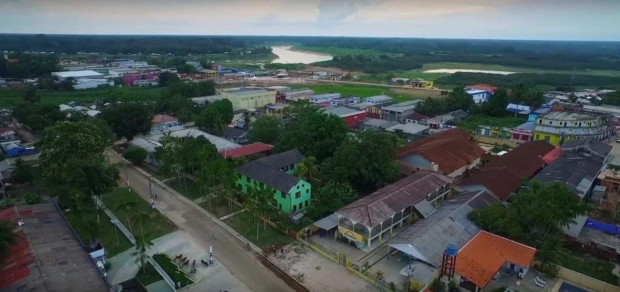
From the Air
Located at 6.66°S, 69.87°W in far-western Brazilian Amazonia. Recommended viewing altitude 8,000-12,000 feet (2,400-3,600 m) for meandering river views. Amaury Feitosa Tomaz Airport (SWEI) is the main gateway; flights connect through Manaus (SBEG). Look for the wide, muddy meanders of the Juruá River winding south from the Amazon, with the Tarauacá joining from the east. Dense rainforest canopy extends in every direction; cloud cover often clears in early morning.
Nearby Stories
- Cujubim Sustainable Development Reserve 90 km away
- Murder of Bruno Pereira and Dom Phillips 215 km away
- Purus National Forest 242 km away
- Cruzeiro do Sul, Acre 274 km away
- Puerto Nariño 283 km away
- Acre River 318 km away
- Matsés National Reserve 352 km away
- Republic of Acre 409 km away