Cruzeiro do Sul, Acre
The constellation that gave the city its name does not appear in northern hemisphere skies. The Southern Cross - Cruzeiro do Sul in Portuguese - hangs above the Juruá River valley in the far western Brazilian state of Acre, and the people who founded a town here in the rubber boom days chose the constellation as their mark of belonging. The city sits 630 kilometers by road from Acre's capital at Rio Branco, deep in the Amazon, six hundred miles from anywhere a tourist would reasonably go. And yet it is the second-largest city in Acre, a regional capital for the Upper Juruá, and a place where a 600-mile drive feels like nothing if you have business that the river will not handle.
The River That Built It
The Juruá River winds through the western Brazilian Amazon, doubling back on itself in the dramatic meanders that the satellite images make famous. Cruzeiro do Sul sits on its banks, just south of the Amazonas state line and just east of the Peruvian border. The municipality borders the small towns of Porto Walter, Rodrigues Alves, Tarauacá, and Mâncio Lima - none of them familiar names outside Acre, but each its own riverside settlement carved from the rainforest. The municipality contains 23 percent of the 846,633-hectare Serra do Divisor National Park, established in 1989, which protects one of the most isolated stretches of forest in the entire Amazon. The park sits on the Brazil-Peru border, where the Andes finally give up the last of their elevation and dissolve into the lowlands.
Rubber and the Spiritans
Cruzeiro do Sul exists because of rubber. Throughout the late nineteenth and early twentieth centuries, the Amazon rubber boom drew waves of migrants up the rivers - from northeastern Brazil, from southern Europe, from anywhere where someone had heard the prices and decided to chance the trip. Rubber from Hevea brasiliensis trees, scattered through the dense Amazon canopy, could be tapped sustainably by people willing to live deep in the forest along long, looping trails. Cruzeiro do Sul became one of the trading centers where the latex was collected and shipped down the Juruá toward markets. In 1915, Spiritan priests - members of the Congregation of the Holy Spirit, a French Catholic missionary order - founded the parish that would become Catedral Nossa Senhora da Glória, the first church in the Juruá valley. By 1930, the territory had been divided and German Spiritan priests were assigned to the Upper Juruá. Many German immigrants followed.
The Cold That Comes from the Andes
Most of the time, Cruzeiro do Sul has the climate you would expect of an Amazon city near the equator: hot, humid, sweltering days with average highs above 30 degrees Celsius every month of the year, average annual temperature around 25.6, and rainfall topping 2,000 millimeters spread across long wet seasons. But twice in recorded history, the temperature has dropped below 2.4 degrees Celsius - once in May, once in November - which would be unremarkable in Sao Paulo and is genuinely strange in equatorial Acre. The lowest temperature ever recorded was 2.2 degrees. The highest was 43.3. This kind of swing happens because cold air masses from the Argentine pampas occasionally push north through the Amazon basin, a phenomenon locals call friagem - the chill. For a few days the rainforest can feel like a temperate forest. Then the heat returns and the river breathes its usual fog.
Less Sun than London
Cruzeiro do Sul receives about 1,337 hours of sunshine per year. London, the city famous in its own English-speaking world for being chronically overcast, gets considerably more. The reason is that the cloud cover here is almost permanent: dense Amazon humidity, frequent afternoon thunderstorms, and a wet season that runs from October through April with 14 to 18 rainy days each month. The sunniest month, July, manages 182 hours of sunshine - which is fewer than many temperate cities get in a single summer week. This is what life under the canopy actually feels like, even from above the canopy. Even compared to Manaus, the great Amazon city downstream, which gets nearly 1,775 hours of sunshine despite receiving more rain, Cruzeiro do Sul comes out gloomier. The combination of heat, humidity, and chronic cloud cover defines the rhythm of the place.
The City Beyond the Road
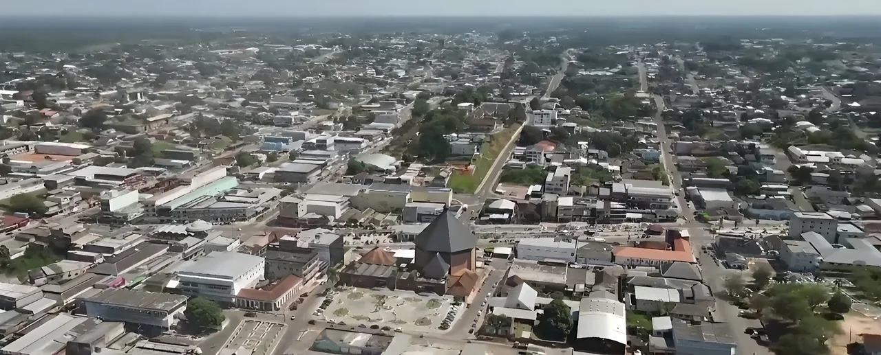
Cruzeiro do Sul International Airport handles flights to Rio Branco and to other regional centers. The BR-364 highway connects the city to Rio Branco, but for most of its history the river was the only reliable way to reach Cruzeiro do Sul, and even now the road can be impassable in the wet season. The economy still rests on rubber extraction and export, with secondary income from cassava, coffee, and rice. Maize and coconut plantations spread out around the urban core. The Catedral Nossa Senhora da Glória rises in the city center, more than a century old, the visible mark of those Spiritan and German priests who came up the Juruá when getting here was harder than it is now. The Union Bridge crosses the river. The Juruá Hospital handles a regional population that scatters across vast distances of forest. And every clear night, you can step outside and find the Southern Cross right where the city's namers told you it would be.
From the Air
Coordinates 7.63°S, 72.67°W, on the Juruá River in the western Brazilian state of Acre, near the Peruvian border. Elevation approximately 170 meters. Recommended viewing altitude: 2,500-4,000 meters AGL to see the meandering Juruá River and the surrounding rainforest canopy stretching to the horizon. Cruzeiro do Sul International Airport (SBCZ) serves the city. Visibility frequently limited by cloud cover and afternoon thunderstorms; the area receives less than 1,400 hours of sunshine annually. The Serra do Divisor mountains rise to the west along the Peru border.
Nearby Stories
- Pucallpa 165 km away
- Matsés National Reserve 186 km away
- Eirunepé 255 km away
- Peruvian Amazonia 316 km away
- Nauta 338 km away
- Gran Pajonal 363 km away
- Cujubim Sustainable Development Reserve 403 km away
- Manu National Park 473 km away