Gran Pajonal
In 1742, an Asháninka leader named Juan Santos Atahualpa led a rebellion that destroyed every Franciscan mission in the Gran Pajonal and kept the plateau in indigenous hands for the next 150 years. That is the core fact of this place, and anyone telling the story honestly has to start there. The Spanish never came back in force. The rubber tappers eventually did, and the missionaries eventually did, and the Peruvian army eventually did. But the Asháninka are still here. In 2002, out of a population of roughly 7,000 people scattered across the plateau, 90 percent were Asháninka. The grass patches that give the Gran Pajonal its name - Great Scrubland in Spanish - exist because Asháninka farmers have been cultivating them for centuries, perhaps millennia, carving open spaces out of the surrounding rainforest.
The Grasslands That Humans Made
The name Gran Pajonal puzzles visitors expecting savanna. The plateau lies in the upper Amazon basin, surrounded by tropical rainforest on every side. But at its elevation - ranging from about 900 to 1,400 meters - and after centuries of Asháninka agriculture, small patches of grassland cover roughly 4 percent of the total area. These are anthropogenic grasslands, meaning they exist because of human activity. The Asháninka practice slash-and-burn agriculture focused on manioc (yuca in Spanish), though a single farmer might cultivate as many as 50 different plants: bananas, peanuts, beans, and many more. The grass appears where gardens have been abandoned long enough for the soil to shift toward open meadow. Since 1975, an additional 3,500 hectares of grassland has been created by Andean immigrants, mostly for pasture - a different kind of land use, with different consequences for the surrounding forest.
Juan Santos Atahualpa
In 1733, a Franciscan named Juan Bautista de la Marca became the first Spaniard to visit the Gran Pajonal. The plateau was attractive to missionaries: it had a relatively dense indigenous population and a cooler, healthier climate than the Amazon lowlands. By 1735, an armed Spanish expedition was working among the Asháninka, and by 1739, Franciscans had established missions in ten villages. The Spaniards followed their standard strategy of reductions - forcing indigenous people to abandon dispersed settlements and live in mission towns where they could be controlled, converted, and taxed. In 1742, Juan Santos Atahualpa, who claimed descent from the Inca royal line, led a rebellion that swept through the missionary enterprise. The missions were burned. The Franciscans fled or died. The Spanish never regained control of the Gran Pajonal. Juan Santos remained a largely legendary figure - he disappeared from historical records around 1756 - but his rebellion held.
Beyond the Spanish Reach
For a century and a half after 1742, the Gran Pajonal was Asháninka territory in a way few places in Peru remained. The plateau is difficult to reach: it has no navigable rivers crossing it, and its elevation creates a hard transition from the surrounding lowland forest. Mountains on nearly every side - the El Sira Communal Reserve to the north, the Cerro de la Sal range to the south - compound the isolation. The Asháninka of the Pajonal speak a distinct dialect that scholars often call Ashéninka to distinguish it from the more widespread Asháninka language spoken closer to the Ene and Tambo rivers. European diseases still took their toll during these centuries, brought through occasional contact, and in the late 19th century slave raids by rubber companies began penetrating the plateau. But the core fact of Asháninka sovereignty persisted in a way few comparable peoples managed.
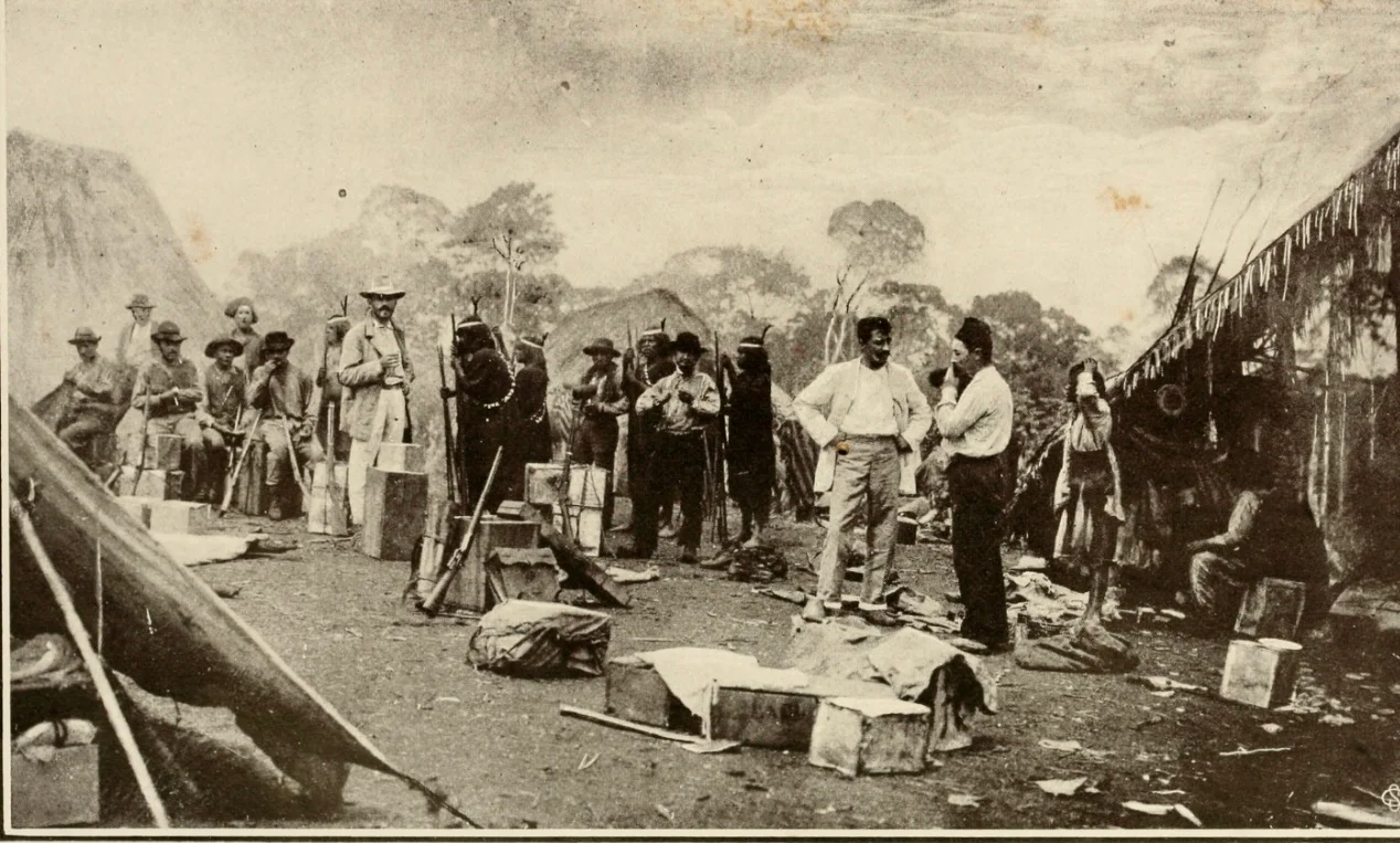
The Wars Return
In 1896 and 1897, the Franciscan priest Gabriel Sala visited the Gran Pajonal accompanied by armed men. His expedition opened a second wave of outside attention: plans for roads and railroads, new missions attempted and mostly failed. By 1935, three Catholic missions had been re-established, and in 1938 an airstrip was built at Oventeni, the largest of the mission settlements. In 1965, the Peruvian army entered the plateau in pursuit of the Left Revolutionary Movement, a Marxist guerrilla group. The army defeated the guerrillas and then stayed in Oventeni for three years, during which the Catholic missions were closed. That same year, the Wycliffe Translators - Protestant missionaries - began working in the area, and most Asháninka who converted chose Protestantism. In the 1980s, the Shining Path insurgency brought devastating violence to Asháninka communities further east, along the Ene and Tambo. The Gran Pajonal itself was less affected, but the memory of those years shapes everything about how the community organizes.
Thirty-Six Communities, Legal Title
In the 1980s, with assistance from the World Bank and the government of Denmark, the Asháninka of the Gran Pajonal achieved legal title to most of their land. Ownership was formally deeded to 36 separate communities, with non-Asháninka allowed to reside and own land only within the community of Oventeni at the center of the plateau. The population balance held: roughly 6,500 Asháninka against about 650 outsiders, mostly Andean Peruvians who had migrated in seeking farmland and work. Some Asháninka worked as cattle herders or coffee harvesters for the outsiders. Others continued traditional agriculture on community land. The legal titles did not end the pressures - they continue, from logging, from coca cultivation, from the general encroachment of modern Peru - but they provided something the Asháninka had not previously had in writing: recognition that this land was theirs. Juan Santos Atahualpa's rebellion had won it. Centuries of stubborn persistence had held it. The paperwork finally caught up.
From the Air
Located at 10.75°S, 74.22°W in Peru's central Amazon region, spanning Ucayali, Pasco, and Junín departments. Recommended viewing altitude 6,000-9,000 feet (1,800-2,700 m) above the plateau surface, which sits at roughly 1,000 m. Oventeni has a small airstrip built in 1938; no commercial service. Nearest commercial airports are Atalaya (SPAY) and Satipo. Look for patches of grassland breaking the rainforest canopy - a distinctive mottled pattern that gave the region its name - with the El Sira range visible to the north and the Ucayali River to the east.
Nearby Stories
- La Merced 57 km away
- Battle of Junin 120 km away
- Putis massacre 168 km away
- Huánuco 217 km away
- Manu National Park 264 km away
- Machu Picchu 297 km away
- Cruzeiro do Sul, Acre 348 km away