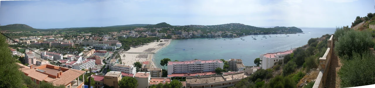

Santa Ponsa
A stone cross stands at the mouth of the marina, easy to walk past on the way to a sun-lounger. It marks the spot where, on 12 September 1229, King James I of Aragon waded ashore and began the conquest that would end more than three centuries of Muslim rule on Mallorca. Santa Ponsa has never forgotten it. Each September the town restages the landing on its own beach — a mock battle of Moors and Christians, followed by a pop concert and fireworks, stretched across two weeks of festival. The rest of the year this small Calvià resort, eighteen kilometres from Palma, trades history for sunshine.
Rushes, Not a Roman Villa
For a long time the townspeople told themselves the name came from Rome — from a villa supposedly called Santa Ponctia, a tidy classical pedigree. The truth is humbler and older. 'Santa Ponsa' descends from the Arabic Sanat Busa, meaning a place of rush bushes, a reminder that for more than three hundred years this was Muslim land, part of an island the wider Christian world had all but forgotten. The marshy, rush-fringed shore that gave the town its name was unremarkable — which is exactly why it mattered to a king looking for a quiet place to land an army unopposed. Names, after all, carry their history whether or not a town cares to remember it.
The King Who Waded Ashore
James I of Aragon — Jaume, to Catalans — was still in his early twenties when he chose this beach for his invasion in the autumn of 1229. His landing succeeded, the island fell, and Mallorca passed into the Crown of Aragon, and in time into the Monarchy of Spain; the shape of the modern island was set on this shore. For a place that had been Muslim for more than three centuries, 1229 was not merely a change of ruler but a change of world. The cross at the marina entrance fixes the moment in stone. But it is the September fiesta that keeps it alive: for two weeks the town gives itself over to the anniversary, and on the sand the old conflict is fought again in costume, Moors against Christians, before the whole thing dissolves into music and fireworks. It is history as a party — earnest and theatrical at once.
The Package-Holiday Coast
For most of its visitors, though, Santa Ponsa is simply a beach. From May to October it fills with sun-seekers from the colder corners of Europe — Germans, Dutch, Irish, and Britons chief among them — and the hills on either side of the bay have sprouted villas and apartments bought by those who keep coming back. In recent years the town has drawn a younger, louder crowd as well, helped by its nightlife and its short hop from Magaluf; one survey once ranked it among the top holiday spots for older teenagers. It is not Magaluf, quite, but it shares that coast's easy, package-deal appeal, and makes no great secret of it. The result is a town that empties and refills with the calendar, boisterous in August and half-asleep by December.
Fairways, Yachts, and a Cable to the Mainland
Behind the beach lies a town well stocked with the machinery of leisure. Santa Ponsa has three golf courses, and one of them, Santa Ponsa II, has hosted a PGA European Tour event; its members-only eighteenth green is cut in the shape of Majorca itself, an island of turf marooned in a pond and reached by a footbridge. Down at the water, the private marina — Club Náutico Santa Ponsa, opened in 1975 in the natural cove of Sa Caleta — can berth well over five hundred boats. There is even an English-language school, the Baleares International College, founded in 1956. And in a final, unglamorous twist, the town hosts the island's landfall for the COMETA cable, the undersea power link that ties Mallorca's electricity to the Spanish mainland. Sun, sport, and a strand of the national grid — Santa Ponsa quietly does more than sunbathe.
From the Air
Santa Ponsa lies at 39.515°N, 2.483°E, on Mallorca's southwest coast in the municipality of Calvià, about 18 km west of Palma. From Palma de Mallorca (LEPA), roughly 22 km east, follow the coast westward past Magaluf and Palma Nova. Visual landmarks include the wide sandy bay, the marina with the commemorative cross at its sea entrance, and the low hill of Puig de sa Morisca just inland. A viewing altitude of 2,500-4,000 ft AGL takes in the bay, the golf courses stitched into the hills behind, and the headland toward Port Adriano. The coast is usually clear, though the LEPA approach corridor and summer haze call for care.
Nearby Stories
- Deia 2.4 km away
- Manacor 13 km away
- Fundacion Yannick y Ben Jakober 13 km away
- Illa de Tagomago 44 km away
- Cala de Sant Vicent 62 km away
- S'Argamassa Roman Fish Farm 95 km away
- Illa Grossa 123 km away
- Shipwreck of Dellys 262 km away