Torrinha
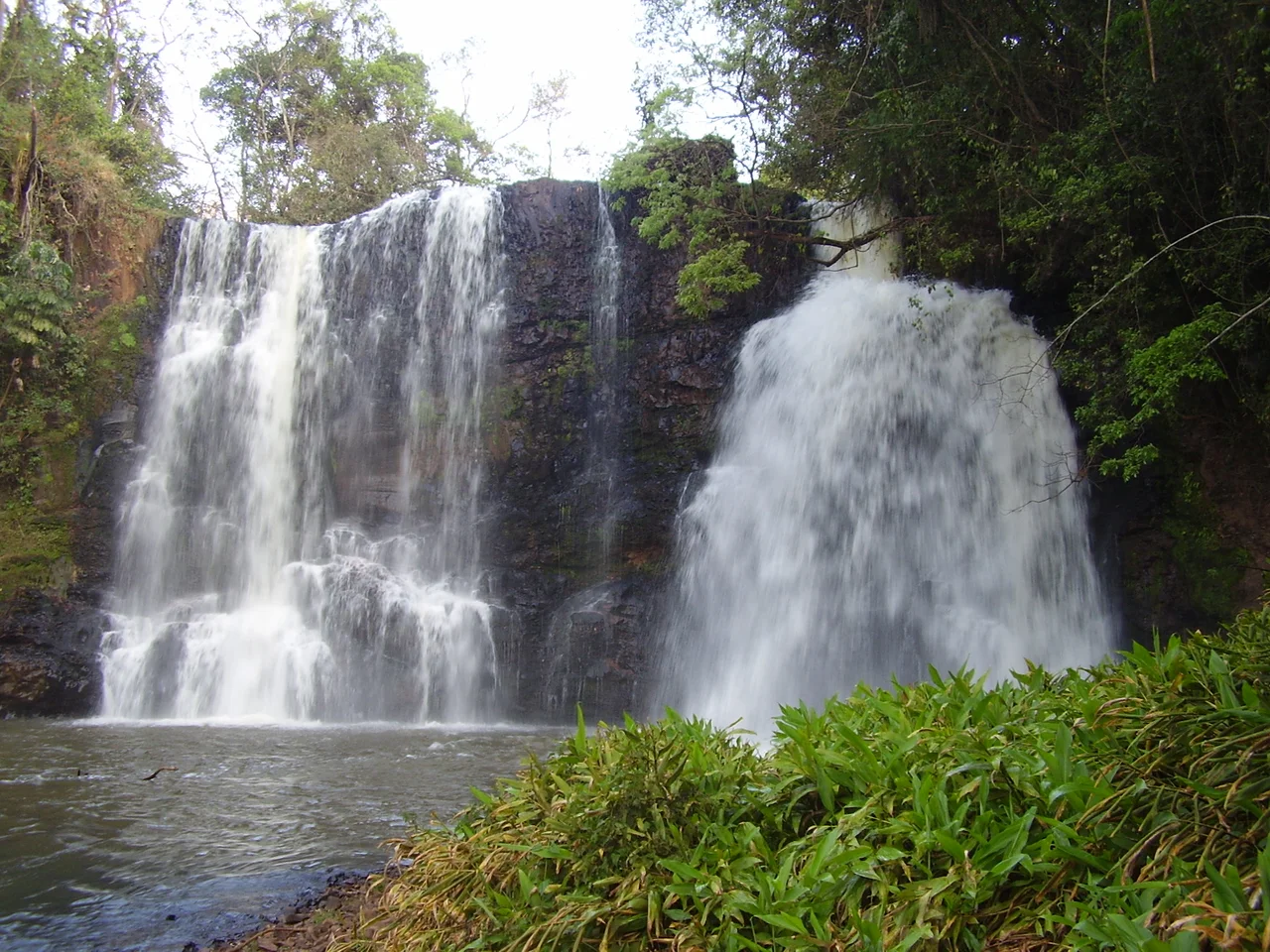
Thirty-four canyons cut through the sandstone country around this town of 9,846 people, their walls rising up to 100 feet out of the western São Paulo plateau. Waterfalls drop into narrow valleys that are still mostly unexplored. Gallery forests cling to the slopes where settlers could not clear them. The canyons were an embarrassment in the early twentieth century - land that could not easily be plowed or planted - and that failure to develop is exactly what saved them. Today the rock walls of Torrinha preserve one of the most intact patches of Atlantic Forest biodiversity left in the state of São Paulo, hidden in plain sight behind a quiet municipality that most Paulistas have never heard of.
A Chapel at the Beginning
The town traces its founding to around 1870, when José Antunes de Oliveira donated a small parcel of land to the Bishopric of São Paulo, with a chapel erected in honor of San José - Saint Joseph, the city's patron. This was nineteen years before Brazil became a republic. Before that, in the seventeenth and eighteenth centuries, tropeiros - muleteer traders - had crossed these lands in search of wealth, building up small way-stations for supplies, services, and repairs. The Land Law of 1850 then formalized the patterns that had emerged, encouraging small farmers from nearby regions to settle the area. Pioneering family names still survive in Torrinha: Fonseca Costa, Mello, Dias, Ferreira, Ferraz, Carvalho, Franco de Moraes, and many others.
The Baron's Son Returns
In 1886 Bento Lacerda arrived. He was the son of the Baron de Araras - Benedict Lacerda Guimarães - and Dona Manuela Franco, and he had just come home from Hannover, Germany, where he had studied at the Polytechnic University specializing in chemistry and mining. The Baron had purchased large tracts of land in the region, and Bento took up the challenge of working them. The creation of the District Police in 1892 and the District of Peace in 1896 is attributed to him. Six years before Bento arrived, in 1880, Jerome Martins Coelho - grandson of the Lord of Cocais - had come from Mata in Minas Gerais and acquired lands stretching to Santa Maria da Serra, Brotas, and beyond. On his farm, where the Plant of the Three Falls now stands, he built one of the first Presbyterian churches in the state - an unexpected pocket of Protestantism in a deeply Catholic country region.
Sugar, Then Coffee, Then Rail
The economic development of the region accelerated in the nineteenth century with sugar plantations. Torrinha sat close to the sugar farming areas of Piracicaba, Araraquara, and São Carlos. Sugarcane drew immigrants in, but local growing conditions turned out less favorable than hoped, and growers pivoted to coffee. Coffee culture in turn demanded rail transport. The station of Santa Maria - later renamed Torrinha - opened on September 7, 1886, built by Paulista de Estradas de Ferro (the same company behind the big São Carlos station a short distance away). The railway gave the town a way to ship coffee out and brought new immigrants in. For a stretch of years in the late nineteenth and early twentieth centuries, Torrinha was a functioning part of the São Paulo coffee economy - a small but real node on the network that ran to Santos and the sea.
The Cuestas
Torrinha sits on the western São Paulo plateau, inside the geotectonic unit known as the Paraná Basin. Thick sedimentary masses and basaltic volcanic eruptions accumulated here through the Cenozoic, between roughly 70 and 12 million years ago. Underground tectonic and erosive processes carved the characteristic festooned-scarp relief of the region - the "cuestas," arranged in arcs facing toward the Brazilian Highlands. Torrinha's rock is part of this system. Rock walls hundreds of meters long and up to 30 meters tall loom above narrow canyons. Caves of sandstone and basalt pepper the hillsides. The preservation is partly natural - the terrain resisted clearing - and partly a gift from agricultural frustration. Settlers simply gave up on much of this ground.
Five Percent of the Original
About 5% of the municipality's original native vegetation remains, and almost all of it sits on those slopes that proved too steep to farm. Savanna and broad-leaved tropical forest species survive in small isolated pockets, though they have been almost completely decimated elsewhere by agriculture and stock breeding. The rock walls that frustrated the settlers became a sanctuary - a biodiversity reserve nobody planned but that the landscape created on its own. In a state where the Atlantic Forest has been reduced to tiny fragments, Torrinha's cuesta canyons hold a disproportionate share of what was once standard São Paulo ecology. The forests along those canyon floors are essentially irreplaceable - regrowth takes centuries, and the original seed sources are mostly gone from the surrounding countryside.
A Quiet Place at 802 Meters
The population stays small - 9,846 as of 2015. Elevation is 802 meters. The town center is compact, with colonial-era residential patterns still legible in the street grid. Media reached the town later than bigger cities: Companhia Telefônica Brasileira served the area until 1973, when Telecomunicações de São Paulo took over, and after 1998 the system passed to Telefónica, which adopted the Vivo brand in 2012. Most visitors who come to Torrinha come for the canyons - the eco-tourism potential has been recognized for decades, though infrastructure remains modest. From the air, the town reads as a small grid tucked against the edge of the cuesta, with the green scars of the canyons radiating out into the countryside like the negative space of a landscape that never got tamed.
From the Air
Located at 22.43°S, 48.17°W, Torrinha sits at 802 meters elevation on the western São Paulo plateau. The municipality lies between Piracicaba and São Carlos, in the cuesta country of the Paraná Basin. Key visual features include the 34 canyons carved into the sandstone and basalt escarpments - these appear as dark branching scars through the agricultural patchwork. Nearest airports: São Carlos (SBSC, Mário Pereira Lopes International) ~35 km north; Bauru (SBAE) ~65 km west; Ribeirão Preto (SBRP) ~120 km northeast. Surface highway reference: the region is accessed via SP-225. Recommended viewing altitude: 5,000-8,000 feet AGL for canyon and cuesta detail.
Nearby Stories
- São Paulo (state) 13 km away
- Bauru 23 km away
- Leme, São Paulo 50 km away
- Brazilian Air Force Academy 52 km away
- Campinas Cathedral Shooting 81 km away
- Pompeia, São Paulo 135 km away
- Atlantic Forest Biosphere Reserve 169 km away
- Wire Opera House 304 km away