Wyndham, Western Australia
The five rivers drain into Cambridge Gulf in a fan of mudflats and mangroves that Europeans first saw in 1819 and apparently found deeply uninviting. They named the rivers — Durack, Pentecost, King, Forrest, and Ord — and moved on. It would take a gold rush to force anyone to actually stay.
Gold, Camels, and a Ghost Town
When gold was discovered at Hall's Creek in 1885, a port was needed to bring in men and machinery across 370 kilometres of baking terrain. Wyndham was it. Afghan cameleers and their animals were imported to handle the heavy freight; ordinary men simply hiked. The original town grew at the port, then collapsed in 1888 when the gold ran out. Wyndham became a ghost town almost as quickly as it had come to life. It survived only because the cattle trade needed a port, and because a meat-packing factory opened in 1913 — the town's main employer until the factory closed in 1985. The town centre relocated inland to Three Mile during this era, and the population stabilised at a level that would not win any records for urban dynamism.
The Doolboong Country
The Doolboong or Duulngari were the Aboriginal people of this place, and their presence here long predates the mudflat and mangrove descriptions of 1819. Their language is now extinct, and they are no longer a distinct identifiable group. But about half of Wyndham's current population of around 900 is Aboriginal — the people who remain connected to this country are descended from communities that were here for tens of thousands of years before the port, the camels, and the meat-packing factory. The history of the town cannot be told without that continuity, even when the colonial record largely ignores it.
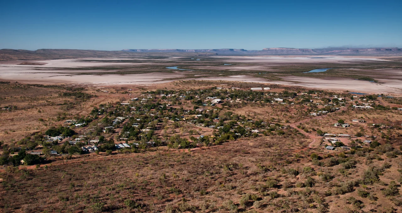
The View from Five Rivers Lookout
Wyndham's most vivid viewpoint sits atop the 360-metre Bastion Range at the end of Hugo Austla Drive, reached by a sealed road from the hospital. The view from the top takes in the town below, the five river mouths draining into the Cambridge Gulf, and the flat expanse of mudflats stretching to the horizon. It is, by most accounts, best at sunset, when the light turns the mud to gold and the distant water to copper. The 18-metre saltwater crocodile that greets arrivals into town is a different kind of orientation: one of Australia's celebrated 'big things,' functional as a photo opportunity and redundant as a warning, given that the actual crocodiles in the rivers below need no advertisement.
A Ship in the Shallows
Forty metres north of the wharf, the rusted hulk of a 4,000-tonne merchant ship sits in the mud at low tide. The vessel was attacked by Japanese Kawanishi flying boats on 20 February 1942, badly damaged and beached about 150 kilometres west of town. A dispute between the captain and first officer about whether to attempt to reach port meant passengers and crew camped in the crocodile-infested mangroves for five days before a lugger arrived. The ship eventually made it to Wyndham, unloaded most of its military cargo, and rolled over in the shallows. In 1948 the hulk was dragged to its present position to clear the harbour. It remains visible at low tide, a slow dissolution into the mud of Cambridge Gulf.
From the Air
Coordinates: 15.483°S, 128.123°E. Wyndham sits at the eastern end of the Kimberley, at the head of Cambridge Gulf. The five river mouths are visible from the air as dark channels cutting through the pale mudflats. The Bastion Range — 360 metres above town — is a distinct topographic feature on approach from the south. Wyndham airstrip is on the east edge of town; nearest commercial airport is Kununurra (YPKU), 100 km southeast. No mobile signal in town as of mid-2024.
Nearby Stories
- Forrest River Massacre 33 km away
- The Speewah 49 km away
- Drysdale River National Park 91 km away
- Bilinarra Language 102 km away
- Argyle Diamond Mine 103 km away
- Gibb River Road 132 km away
- Auvergne Station 144 km away
- Victoria River Downs Station 259 km away