Yungas Road
The guardrails never existed. For decades, the North Yungas Road was simply a narrow shelf of dirt carved into near-vertical mountainsides, with drops of 600 meters or more on one side and rock walls on the other. Buses, trucks, and cars shared this single-lane track, and when two vehicles met on a blind curve, someone had to reverse. The road earned its nickname -- La Ruta de la Muerte, the Death Road -- through sheer accumulation: estimates ranged from around 100 to as many as 200 to 300 fatalities per year when it served as the main corridor between La Paz and the Yungas lowlands. That grim era ended when a modern highway replaced it. What remains of the original road is now Bolivia's most popular adrenaline attraction, a 64-kilometer mountain bike descent that drops from the freezing altiplano at nearly 4,700 meters to the subtropical town of Coroico at 1,700 meters.
Built by Prisoners, Traveled by the Desperate
The road was constructed in 1930 by Paraguayan prisoners of war during the Chaco War, a brutal conflict between Bolivia and Paraguay over the disputed Gran Chaco region. Using hand tools, the prisoners carved a route through some of the most treacherous terrain in the Andes -- steep gorges, unstable slopes, and cloud forests perpetually soaked in mist. The road connected La Paz to the Yungas, the transitional valleys where the Andes plunge toward the Amazon basin. For the communities living in these valleys -- farmers growing coca, coffee, bananas, and citrus -- the road was a lifeline, the only motorable link to the capital. That it was also terrifyingly dangerous was simply a fact of life. Single-lane, unpaved, and lacking any safety infrastructure, the road wound along cliff edges where a moment's inattention meant a fatal plunge. The Inter-American Development Bank named it the world's most dangerous road in 1995, a designation that stuck.
The Descent
The ride begins at La Cumbre, the highest point between La Paz and Coroico, where the air is thin and the temperature hovers near freezing. From here, the first stretch follows the modern paved highway -- fast, wide, and relatively safe. Then the route diverts onto the original Yungas Road, and everything changes. The pavement disappears. The lane narrows to barely three meters. Waterfalls cascade directly across the road surface. Fog rolls in without warning, reducing visibility to a few bike lengths. The drop-off, unguarded by any barrier, is immediate and absolute. Over the next several hours, riders descend more than 3,000 vertical meters through a series of ecological zones: from barren altiplano to montane cloud forest to lush subtropical vegetation. The air thickens and warms. Orchids and ferns replace rock and ice. By the time the road reaches Coroico, riders have shed their cold-weather gear and are sweating in the humid lowland heat.
The Yungas Beyond the Road
The Death Road's fame has overshadowed the region it passes through, but the Yungas themselves reward those who linger. This is where the eastern Andes dissolve into the Amazon basin, and the ecological transition is staggering. Within a few hours' drive, the landscape shifts from high-altitude grassland to dense tropical forest. Coroico, the main town, sits on a green ridgeline with views across valleys thick with vegetation. Hiking trails lead to wild rivers, waterfalls, and Afro-Bolivian communities whose ancestors were brought to work the region's colonial-era haciendas. The Takesi Inca Trail -- a demanding 40-kilometer route from La Paz to the village of Yanacachi along the South Yungas Road -- follows pre-Columbian stone pathways over a 4,600-meter pass and down into the valley. Coca, the sacred leaf of Andean culture, grows on terraced hillsides alongside coffee and citrus. The Yungas are not just a backdrop for the Death Road. They are a world unto themselves.
Reputation Versus Reality
The mountain biking industry has transformed the Death Road from a transportation hazard into a tourism product, complete with professional guides, quality rental equipment, and safety briefings. Since commercial cycling operations began in 1998, at least 18 biking fatalities have been recorded -- a grim number, but a fraction of the road's automotive death toll. The distinction matters. When the road carried daily bus and truck traffic, the danger was systemic: poor vehicles, no safety standards, frequent fog, and a culture of driving that prioritized speed over caution. For cyclists today, the risks are real but manageable. Tour operators shuttle riders to the start, follow the group in support vehicles, and provide helmets and full-face protection. The road's reputation -- burnished by countless travel blogs and bucket-list articles -- has made it one of Bolivia's top tourist draws. Some purists grumble that the experience has been commercialized beyond recognition, that the name 'Death Road' is now more marketing slogan than accurate description. They have a point. But standing on a ledge at 4,000 meters, fog swirling below, the drop-off vanishing into white -- the road still earns its name.
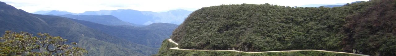
From the Air
Located at 16.34S, 68.04W in the La Paz department of Bolivia. The road descends from La Cumbre pass (~4,700 m ASL) to Coroico (~1,700 m ASL) along the eastern slope of the Andes. From altitude, the route is visible as a thin line etched into steep green mountainsides, with dramatic switchbacks and cliff faces. The terrain drops sharply from the Altiplano into cloud forest and subtropical vegetation. Nearest major airport is El Alto International Airport (SLLP) in La Paz, approximately 60 km to the west and one of the world's highest commercial airports at 4,061 m ASL. The road threads through deep gorges with 600+ meter vertical drops visible from above.
Nearby Stories
- Tiwanaku 13 km away
- Battle of Ingavi 41 km away
- 1975 Transporte Aéreo Militar Convair CV-440 crash 48 km away
- Copacabana 57 km away
- Cordillera Real (Bolivia) 64 km away
- Sacambaya River 97 km away
- Taquile Island 123 km away
- Pilón Lajas Biosphere Reserve and Communal Lands 142 km away