The 49er Fire
Gary Wayne Parris's first words, when the sheriff's deputy found him twelve miles from where it started, were: "I'm in trouble, aren't I?" He was. On the morning of September 11, 1988, Parris -- a homeless man with undiagnosed schizophrenia, sheltering in an abandoned shack without electricity or running water on Birchville Road -- had set fire to torn strips of paper grocery bags he'd used as toilet paper. A gust of wind carried the burning scraps into nearby brush. He ran to a pond for water, filled buckets, and tried to put it out. When that failed, he flagged down motorists on Highway 49 and begged them to call the fire department. By then, the Sierra foothills were already burning.
Tinder and Wind
The conditions that turned a small brush fire into a catastrophe had been building for months. In 1988, at least twelve California counties had declared local drought emergencies. The Sierra Nevada foothills northeast of Sacramento were parched, and the wildland-urban interface zone around Grass Valley and Nevada City was among the fastest-growing such areas in the state -- houses spreading into landscapes that had evolved to burn. On September 11, a textbook Northern California critical fire weather pattern locked into place. An upper-level trough sliding east from Washington and Idaho combined with a ridge building offshore in the Pacific, generating fierce Foehn winds that poured down the western slopes of the Sierra. Humidity plummeted. Winds gusted to forty miles per hour. Into this powder keg fell the burning paper from Birchville Road.
A Hundred Acres by Eleven
A fire crew from Columbia Hill Forest Fire Station spotted the smoke on their way back from another call. They tried to stop it and failed. A motorist scraped a crude firebreak with a shovel. That failed too. A second fire appeared a mile southwest, near Pine Grove Reservoir -- whether a spot fire, a downed power line, or a separate ignition remains unknown. The two blazes merged and began to run. By ten in the morning, the fire had consumed its first acres. By eleven, a hundred. It crossed the South Yuba River around one in the afternoon, and by then flames exceeded two hundred feet in height. Structures on Owl Creek Road and McKitrick Ranch Road were burning. When the wind shifted suddenly, forty firefighters were overrun and forced to deploy their fire shelters, though all survived. A bulldozer operator, engulfed by flame, crawled beneath his machine and wrapped himself in an asbestos blanket. By noon, twelve thousand acres had burned.
Eight Thousand Flee
At 3:15 p.m., Nevada County sheriff's deputies ordered the complete evacuation of Rough and Ready. An inversion layer trapped smoke against the ground, cutting visibility and grounding the air tankers that might have slowed the fire's advance. The smoke suppressed the flames somewhat, but the communities in the fire's path -- Rough and Ready, Cement Hill, Lake Wildwood, Penn Valley -- were emptying. More than eight thousand people fled their homes over the course of the fire. The most serious injuries came at Wildwood Heights, where firefighters Rene Ruiz and Larry Lindbloom were defending a house when their fire engine was overrun. The engine burned alongside the home it was trying to save, and both men were helicoptered to the hospital with second- and third-degree burns to their legs. On September 13, humidity finally rose and the winds relented. The fire was declared ninety percent contained on September 14 and fully controlled at 8:30 p.m. on September 16, five days after Parris lit that match.
The Wildfire of the 1990s
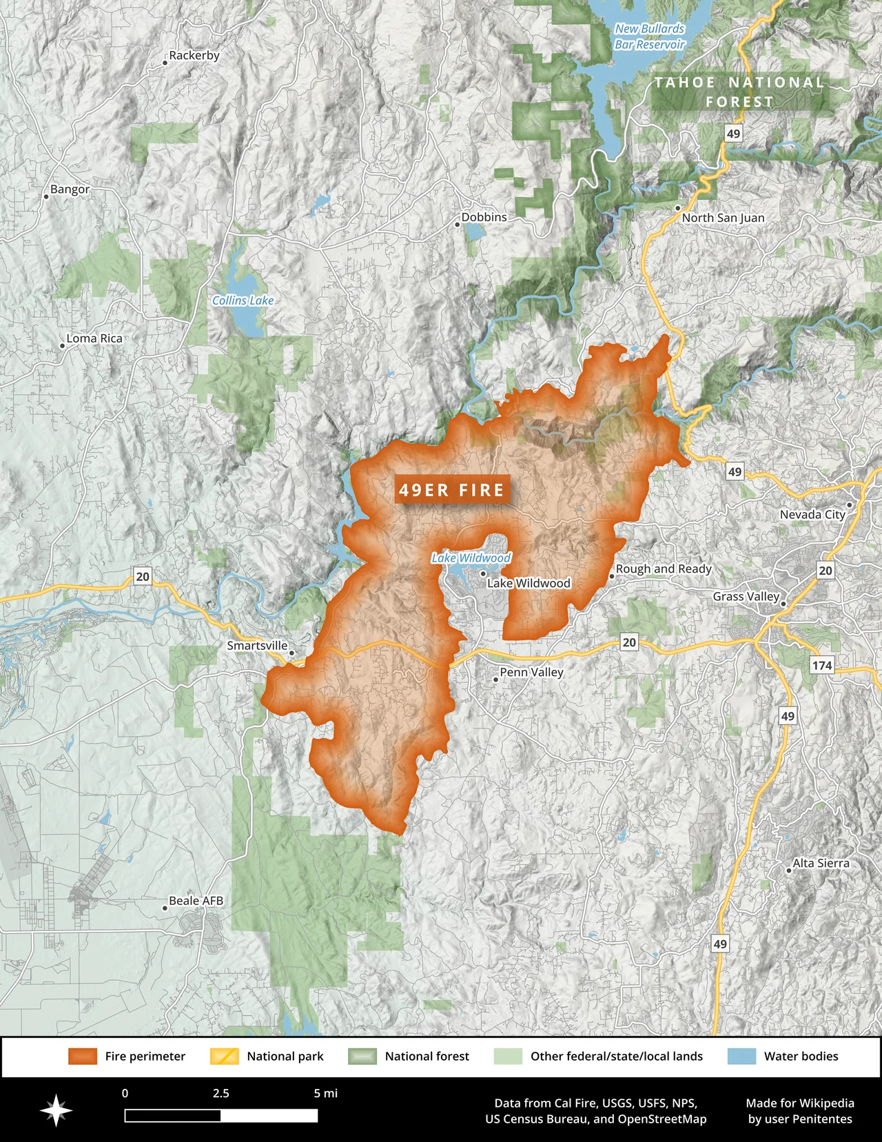
The 49er Fire destroyed 312 structures, including more than 140 homes and 23 mobile homes. Dozens of vehicles and boats burned. Damages totaled twenty-three million dollars, with another six million in suppression costs. Governor George Deukmejian declared a state of emergency. The Small Business Administration approved nearly 1.7 million dollars in recovery loans, and the state provided $174,000 in grants. Cal Fire Director Jerry Partain began calling it "the wildfire of the 1990s," not because it happened in that decade but because it previewed the decade's challenges. State legislators used it to push legislation authorizing bonds for augmenting firefighting resources and reducing wildfire hazards in developed areas. The fire had exposed a fundamental tension: as people built deeper into wildland terrain, firefighters spent more time defending structures and less time fighting fire. During the first several hundred acres of growth, crews were forced to defend fifty-five separate buildings.
A Man with a Bucket
Parris was spotted leaving the shack by deputies responding to the fire. Witnesses told a deputy to look for "a man with a bucket." He was found twelve miles away. In court, he testified that he heard voices, and that the wind that blew the burning paper into the brush had been the work of supernatural forces. The charge was reduced from reckless burning of an inhabited structure to an uninhabited one after testimony confirmed the shack was unfit for human habitation. In February 1989, Parris pleaded not guilty by reason of insanity. He was assaulted and injured in jail while awaiting his verdict. Found legally insane, he was committed to Atascadero State Hospital, a maximum-security psychiatric facility, with the possibility of indefinite extension if deemed a continuing danger. He was released in 2002. Today, the 33,700 acres the fire scarred across the Sierra foothills have largely recovered, but the 49er Fire remains the most destructive wildfire in Nevada County's history -- a reminder that catastrophe can begin with something as small as a scrap of burning paper caught by the wind.
From the Air
The 49er Fire burned across terrain centered near 39.328N, 121.111W in the Sierra Nevada foothills of Nevada and Yuba counties. The fire's 33,700-acre burn scar spread across the communities of Rough and Ready, Lake Wildwood, Cement Hill, and Penn Valley, roughly between Highway 49 and the South Yuba River. From the air, the foothill landscape shows the characteristic mix of oak woodland and suburban development that defines wildland-urban interface zones. Nearby airports include Nevada County Airport (KGOO) about 5 miles northeast and Sacramento Executive Airport (KSAC) about 55 miles southwest. Best viewed at 3,000-5,000 feet AGL to appreciate the terrain and community layout.
Nearby Stories
- The Hospital That Became a County 9.3 km away
- The Middle Mountains Nobody Can Reach 16 km away
- The Yuba County Five 18 km away
- Honey Run Covered Bridge 21 km away
- Western Pacific Railroad Museum 30 km away
- Griffith Mansion 36 km away
- New Melones Dam 120 km away