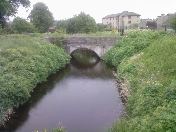

Aberdeenshire Canal
In June 1805, the committee of management for the Aberdeenshire Canal climbed aboard a barge called The Countess of Kintore at Inverurie, decorated for the occasion with flags and bunting. Crowds gathered on the banks. Refreshments were served on deck. At Kintore, the local magistrates met them and pledged toasts. The band of the Stirlingshire Militia joined the procession for the final miles. After seven and a half hours of travel down the strath of the River Don, the barge reached the terminal basin next to the Aberdeen docks, and the committee retired to the New Inn for a celebratory dinner. The canal had taken nine years to build, two acts of Parliament to fund, and a great deal of personal capital. Within six months, fourteen of its seventeen locks had failed.
A Plan That Kept Shrinking
The original scheme, surveyed by Captain George Taylor in 1793, was much more ambitious than what was eventually built. The canal was to run from Aberdeen up through Inverurie to Monymusk, with a branch along the Ury Glen to Insch. By the time anyone got around to raising actual money, the plan had been cut back to the stretch from Aberdeen to Inverurie — eighteen and a quarter miles, with no branches. The first act of Parliament in April 1796 authorised £20,000 in £50 shares; by 1801 the company had only managed to raise £17,800 of it and needed another act, which authorised an additional £20,000 in smaller £20 shares. Money trickled in. Public sales of shares raised some of it. The lease of future tolls, granted to William Kennedy in 1804, raised £10,000 as a mortgage. The engineer was John Rennie — one of the great canal builders of the era, who would go on to design Waterloo Bridge in London. His resident engineer Thomas Fletcher, worried about losing his job, jumped ship in 1801 to work on Union Bridge in Aberdeen.
Vandalism, Granite, and a Reward of £5
The canal was unpopular with some locals. Workmen complained that detractors threw stones and rubbish into the cut, damaged the works, and harassed the boats. The company offered a £5 reward — significant money at the time — for information leading to the conviction of anyone caught sabotaging the construction, and warned that offenders could face penal transportation for seven years. Whether anyone actually got transported to Australia for damaging a canal, the records do not say. The work itself was largely cut through granite — Aberdeenshire's defining stone — and some of the rock excavated to make the canal was loaded onto barges and shipped down to London as building material. The canal eventually had seventeen locks, all packed into the first four miles between Aberdeen harbour and Stoneywood; fifty-six road bridges; twenty culverts; and five aqueducts. From Stoneywood it ran level for fourteen miles to Port Elphinstone, just south of Inverurie. Passengers boarded above the St Machar Drive locks and were carried only on the level top section.
The Lock Failures and Thomas Telford
Within months of opening, fourteen of the seventeen locks failed. The masonry was substandard — too thin, too poorly mortared, or built by contractors who had cut corners under financial pressure. The canal closed for reconstruction. The engineer Thomas Telford — the most distinguished British civil engineer of the age — was brought in to approve the rebuilding. The canal reopened in October 1806. A third act of Parliament in 1809 authorised raising another £45,000 for further work, though it appears the company never actually used that power. The reconstructed canal ran successfully, after a fashion, for nearly fifty years. Passenger services proved popular: two boats a day in summer, one in winter, with three classes of fare. In the fore cabin you paid 2s 6d for the full Aberdeen-to-Inverurie journey; in the after cabin, 1s 6d; outside on deck, 1 shilling. The canal benefited local industries. Quarries near Kintore won a contract to supply 700,000 cubic feet of granite for a project at Sheerness. Granaries went up beside the canal at Inverurie. Inverurie itself grew from 500 people at the start of construction to 2,020 by 1841.
The Sad Things and the End
Not all of the canal's history is bunting and toasts. The company's own minute books record that the banks were used by people driving cattle to water and women doing laundry with tubs — frustrations from a company's point of view but signs that the canal was being woven into everyday life. More tragically, there were a number of cases, recorded in the same minute books, of unwanted newborn babies drowned in the canal. The waterway, like rivers and millponds throughout the British countryside, became one of the places to which desperate women carried the consequences of poverty and social judgement. In 2003, a four-year-old boy died after falling through ice on the remaining stretch at Port Elphinstone; thirty feet of the canal there was filled with rubble and fenced off afterwards. The canal never paid a dividend. It cost almost £44,000 to build, and at its commercial peak in 1853 brought in just £3,062. Negotiations with the Great North of Scotland Railway began in 1845. The contractors actually drained much of the canal before money had changed hands — a breach that had to be repaired. The Aberdeenshire Canal was formally closed in early 1854. The railway, which followed almost exactly the same route, opened to Huntly by September of the same year. A few stretches still survive at Port Elphinstone, labelled Old Canal on Ordnance Survey maps, where a walking path now follows what was once a barge route.
From the Air
The Aberdeenshire Canal ran from Aberdeen Harbour at approximately 57.14°N, 2.08°W northwest to Port Elphinstone at approximately 57.27°N, 2.37°W — a length of about 18 miles up the strath of the River Don. Recommended viewing altitude is 2,500–4,000 feet AGL for following the route. Today the railway from Aberdeen to Inverurie occupies most of the original canal bed; visible remnants are easiest to spot at Port Elphinstone, where a walking path follows the surviving channel. EGPD (Aberdeen International) lies just east of the line, with approaches frequently crossing the route. The terrain rises gently inland — the canal's seventeen locks, all packed into the first four miles, climbed 168 feet from the Aberdeen low-water mark.
Nearby Stories
- Dunnottar Castle 5.4 km away
- Kildrummy Castle 5.9 km away
- Delgatie Castle 10 km away
- Keith, Moray 11 km away
- Battle of Mons Graupius 12 km away
- German submarine U-58 (1938) 84 km away
- Longstone Lighthouse 146 km away
- HMS Daring (H16) 158 km away