Afar triple junction
Three spreading ridges converge in the Afar region, and none of them are finished. The Red Sea is widening to the north. The Gulf of Aden is widening to the east. The East African Rift is stretching to the south for more than six thousand kilometers, from the Afar Triangle all the way to Mozambique. Where the three meet is a rare geological structure called a ridge-ridge-ridge triple junction - three lines of active continental separation intersecting at one point, each one peeling a different piece of Africa away from the rest. Geologists have been arguing since the late 1960s about what will happen here next, and so far the landscape has mostly refused to settle the question.
What Triple Junctions Do
In 1969, geologists Dan McKenzie and Jason Morgan published a classification of triple junctions based on how the three boundaries move relative to each other. A junction where all three arms are spreading ridges is called RRR - ridge-ridge-ridge - and Afar is the textbook example of the type. The Arabian plate is separating from the Nubian (African) plate along the Red Sea rift. The Arabian plate is also separating from the Somali plate along the Gulf of Aden, or Aden Ridge. The Somali plate is separating from the Nubian plate along the East African Rift. Three spreading boundaries, three plates, one point of convergence. According to McKenzie and Morgan's stability model, RRR geometry stays stable through time unless something changes the motions - a rare theoretical luxury in a landscape that keeps changing the motions.
Doming and Rifting
Rifting begins with heat. A mantle plume, a column of hotter-than-average rock rising from deep within the Earth, impinges on the base of a continent's crust and makes it do two things: dome upward, and eventually split. Both happened in East Africa, starting in the Late Cretaceous or early Paleogene - roughly sixty-five to thirty million years ago. The plume is thought to have begun under modern Lake Tana in Ethiopia. Over millions of years the crust bulged into broad domes - the Kenyan dome in the south, the Ethiopian dome in the north - with periods of uplift punctuated by long periods of stability and erosion. The Cretaceous uplift lifted this region by 400 meters. The Neogene uplift, much later, raised it by an astonishing 1,500 meters. The current Ethiopian plateau is the surviving expression of all that plumbing.
The Red Sea and the Gulf
The two northern arms of the junction are already submerged. The Red Sea rift runs along the length of the Red Sea, starting from the Dead Sea in the north and ending at the Afar triple junction in the south. Within it sit submerged volcanoes like Jabal al-Tair, and the seafloor shows the same magnetic stripes that geologists recognize as the signature of new oceanic crust forming. Spreading rates vary along the length, but they are on the order of 7 to 15 millimeters per year. The Aden Ridge running east between the African and Arabian plates spreads at about 17 millimeters per year near the Afar junction. Both of these arms are essentially mid-ocean ridges drowned in salt water, building ocean floor incrementally as the plates drift.
The East African Arm
Only the southern arm - the East African Rift itself - remains mostly above sea level. It runs north-northeast to south-southwest, fed by elevated heat flow from the mantle beneath Kenya and Afar. It splits into two branches as it travels south: the eastern Gregory Rift through Kenya, characterized by high volcanic activity, and the western Albertine Rift through Uganda and beyond, characterized by deeper basins holding the great lakes of Tanganyika, Malawi, and Rukwa. The lakes sit in highly rifted basins where normal faults or strike-slip faults mark the edges of subsiding grounds. Listric faults - curved downward-flattening fractures - produce the correct model for the enormous crustal extension required to keep dropping the floor of those basins deeper without breaking the overall geometry.
Will It Become an Ocean?
Geologists disagree about what comes next for the East African arm. Some have suggested the arm will eventually fail - become an aulacogen, the classic name for a failed rift that once opened but then stopped, leaving a scar in the continental crust without ever producing a mid-ocean ridge. Other analyses of current spreading rates show no signs of slowing, suggesting the arm will eventually succeed. Some models predict a subduction zone will form along the eastern edge of the Somali plate as it stretches between two extensional boundaries and needs somewhere to accommodate the resulting compression. The central Afar region, where the three arms actually meet, is itself an oddity: it has not thinned to the point of producing normal oceanic crust, because so much magma has intruded and underplated the continental rocks that it effectively compensates for the stretching. Magma-compensated thinning is the technical term. Continent refusing to finish breaking is the plain-English version. In about ten million years, perhaps, the East African Rift will be flooded end-to-end, and the Horn of Africa will be an island. For now, the three arms keep pulling.
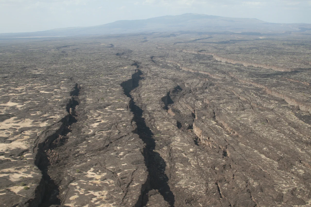
From the Air
Coordinates: 11.500°N, 43.000°E. The geometric point of the Afar triple junction sits in central Djibouti, near the shores of Lake Assal and the Ghoubet al-Kharab bay. From the air, the region reveals intersecting linear fractures running in three directions, visible as aligned volcanic features and fault escarpments. Nearest airport: Djibouti-Ambouli (HDAM). Recommended cruising altitude 10,000+ feet to resolve the three rift arms; lower altitudes reveal dramatic volcanic landscape and the below-sea-level salt flat at Lake Assal.
Nearby Stories
- French Submarine Vengeur 11 km away
- Djibouti 12 km away
- Lake Assal (Djibouti) 20 km away
- Lake Abbe 83 km away
- Berbera 179 km away
- Aden 191 km away
- British Attack on Berbera (1827) 196 km away
- Somaliland 218 km away