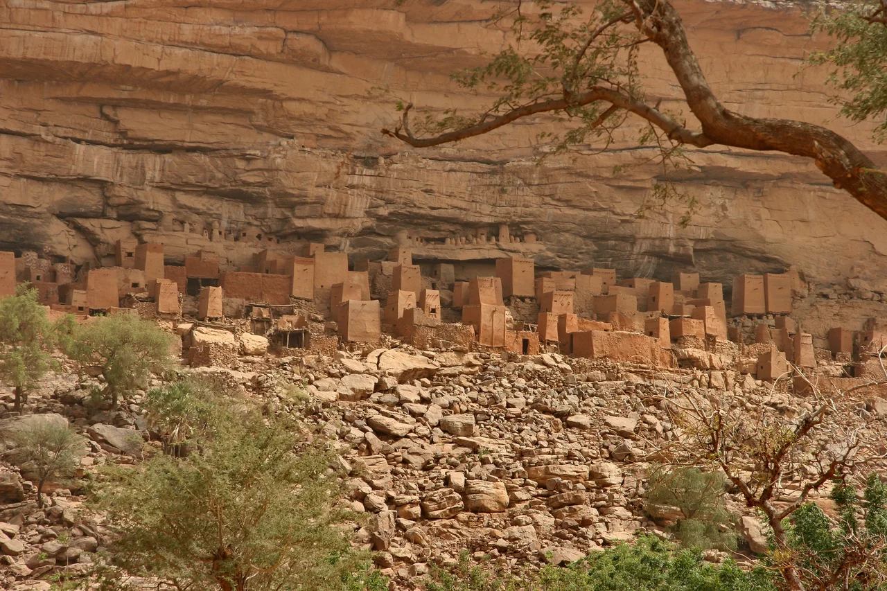

Bandiagara Escarpment
From the open plain it appears like the edge of the world: a single continuous wall of sandstone, rising as much as five hundred meters and running for some hundred and fifty kilometers across the heart of Mali. The Bandiagara Escarpment is not a mountain range but a great fracture in the land, a cliff so long that villages strung along its base seem like beads on a thread. UNESCO inscribed it on the World Heritage List in 1989, calling it the 'Land of the Dogons,' because here geology and human genius have conspired to make one of the world's great cultural landscapes. Look up at the cliff face and you are reading a record of peoples that stretches back more than a thousand years.
Those Who Came Before
The Dogon are only the latest to make this cliff their home. Long before them came the Toloy, and then the Tellem, a cave-dwelling people who lived on the slopes and carved chambers high into the rock. The Tellem are best remembered for what they left in those heights. They cut burial caves far up the cliff so their dead could rest above the reach of the flash floods that scour the plain below, and some of the tapering mud granaries they built still cling to the stone today, many of them still used by the Dogon who followed. To stand at the base and look up at those small dark openings is to look into the work of hands that vanished from here around the fifteenth century.
The Dogon Arrival
Oral history holds that the Dogon arrived near the village of Kani Bonzon in the fourteenth century, and from there spread out across three worlds at once: the sandstone plateau above, the sheer escarpment itself, and the sandy plains of the Seno-Gondo below. They built a civilization vertically. Their architecture is unmistakable, sculptural mud houses, altars thick with the patina of offerings, granaries capped with pointed caps of thatch, and the toguna, the low men's meeting house with a roof so heavy a man cannot stand inside it, deliberately built that way so that arguments stay seated and never come to blows. The cultural landscape today holds hundreds of villages spread across the cliffs and tablelands.
A Fortress of Stone
The escarpment was always more than a place to live. It was a defense. According to Dogon oral tradition, natural tunnels wind through the rock of the cliff, passages known only to the Dogon themselves, and they used this hidden geography to ambush and repel those who came against them. The story goes that this knowledge helped keep them relatively undisturbed even under French colonial power, the cliff itself fighting on their side. The whole formation runs northeast to the Grandamia massif, ending at the Hombori Tondo, at 1,155 meters the highest peak in Mali.
The Future in the Balance
For a time the escarpment drew travelers from around the world, guided along clifftop trails from village to village, the host communities earning their living from small hostels and a tourist tax. But the same fame brought looting of ancient artifacts, and in 2004 the World Monuments Fund placed Bandiagara on its Watch list to call attention to the strain. The deeper crisis came later. Since the 2012 war in Mali, central areas including the Dogon plateau and the escarpment have grown dangerous, caught in conflict and intercommunal violence, and travel here has become inadvisable. The cliff that sheltered the Dogon for seven centuries now shelters a people facing one of their hardest seasons, their extraordinary inheritance hanging, as it long has, between the earth and the sky.
From the Air
The Bandiagara Escarpment runs roughly southwest-to-northeast through central Mali, centered near 14.42 N, 3.32 W. From altitude it is one of the most legible landforms in the Sahel: a single sandstone cliff up to 500 m high and about 150 km long, dividing the elevated plateau to the northwest from the flat Seno-Gondo plain to the southeast. Dogon villages dot the base of the cliff. The formation extends northeast toward the Hombori Tondo (1,155 m), Mali's highest peak. Nearest airport is Mopti-Ambodedjo (GAMB), about 60-80 km to the west near Sevare. The cliff face reads most dramatically in low-angle morning or evening light; harmattan dust may limit visibility December-March.
Nearby Stories
- Battle of Konna 21 km away
- Hamdullahi 31 km away
- Bangime 47 km away
- Battle of Jenné 83 km away
- Ouahigouya 84 km away
- Yacouba Sawadogo 116 km away
- Hand of Fatima (rock formation) 121 km away
- Djenné 136 km away