Batavia Castle
In 1809, Governor-General Herman Willem Daendels did something remarkable: he tore down the most important building in the Dutch East Indies and used the stones to build himself a palace. Batavia Castle had stood at the mouth of the Ciliwung River since the 1620s, serving as the administrative headquarters of the Dutch East India Company's entire Asian operation. Governors-general had lived within its walls, the Council of the Indies had deliberated behind its bastions, and the VOC's vast commercial network had radiated outward from its gates. None of that mattered when Daendels needed construction material for his new urban center at Weltevreden. The castle came down, and its remains slowly vanished beneath the growing city of Jakarta.
Purchased Ground
The castle's story begins with a land deal. Pieter Both, the first elected Governor-General of the Dutch East Indies, sent Captain Jacques l'Hermite to buy 2,500 square vadem - roughly 10,000 square yards - of land in the port settlement of Jayakarta. Prince Jayawikarta, the local ruler, agreed to sell for 1,200 riyals. The plot sat on the east bank of the Ciliwung River, near the Chinatown district, and by 1612 the Dutch had built a lodge, a house, and a trading post they called Nassau Huis. It was a commercial foothold, nothing more. But when the VOC seized Jayakarta outright in 1620, that trading post became the seed of something far more ambitious. The small fortress expanded into a proper castle, ringed by a moat and anchored by four bastions. A 1619 map shows Fort Jacatra alongside the blueprint for what Batavia Castle would become - two structures side by side, the old world giving way to the new.
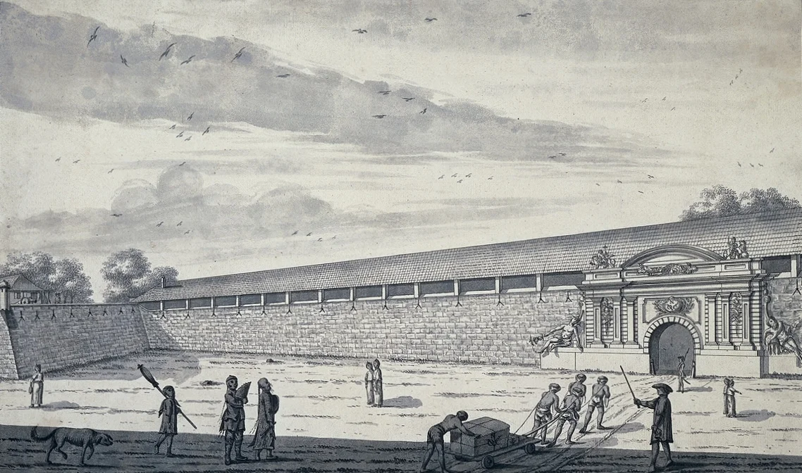
The Company's Throne Room
For nearly two centuries, Batavia Castle was the seat of power for the most profitable corporation the world had yet seen. The VOC controlled the spice trade from the Moluccas to Europe, and every decision about that empire flowed through the castle's walls. The Governor-General - the highest-ranking Company official in Asia - lived here, presiding over the Council of the Indies that governed the Dutch East Indies. A 1682 painting captures the scene: the governor's residence inside the castle walls, an octagonal church in the background, and the quarters of the company directors nearby. By 1738, the governor had installed a duck pond to the west of the castle - a domestic touch amid the machinery of colonial extraction. The castle's sea-facing portal, the Waterpoort, opened toward the harbor that connected Batavia to the trading world beyond. Its land-facing gate, the Landpoort, faced the city that had grown up around it.
Demolished for Convenience
Daendels arrived in 1808 with orders from Napoleon's brother Louis, then King of Holland, and little reverence for VOC tradition. The old town of Batavia was unhealthy - its canals bred disease, and its low-lying position near the coast made it miserable in the tropical climate. Daendels decided to build a new administrative center at Weltevreden, on higher ground to the south, and he needed materials. The castle was the most convenient quarry. In 1809, he ordered it demolished. Workers pulled down walls that had withstood sieges - the castle had survived a major Mataram assault in 1629 - and hauled the stones south to build what became Daendels' Palace. Where the fortress had stood, a road was laid connecting the old town center to Sunda Kelapa Harbor. The Dutch named it Kasteelweg - Castle Street. After Indonesian independence, it was renamed Jalan Tongkol.
Searching for the Foundations
The castle's four bastions survived until 1874, stubborn remnants that outlasted the structure they once defended. After that, even they disappeared. In 1940, archaeologists excavated the site and found the Landpoort - the southern gate that had once welcomed visitors arriving by land. Then the work stopped, and the site returned to obscurity. The former castle grounds became vacant land owned by Jakarta's provincial government. The southern moat filled in with houses, shops, and small businesses. Today, residential flats are rising on the ground where the VOC once governed half a continent. But archaeology has returned alongside construction: excavators working in cooperation with the DKI Jakarta Cultural Heritage Conservation Center and the Association of Indonesian Archaeologists have uncovered the brick floor of the castle's shaft, found two meters below the current ground level. Each dig confirms what maps and paintings already showed - that beneath the modern city lies the foundation of an empire's headquarters, waiting to be read like a buried text.
From the Air
Located at 6.13S, 106.81E at the mouth of the Ciliwung River in North Jakarta, near the historic port of Sunda Kelapa. The castle site is in the Kota Tua (Old Town) district, identifiable from the air by the colonial-era street grid and waterfront location. Nearest major airport is Soekarno-Hatta International (WIII), approximately 25 km northwest. Halim Perdanakusuma Airport (WIHH) lies about 15 km southeast. The Ciliwung River cutting through the urban fabric is a useful visual reference from altitude.
Nearby Stories
- The Scholar's Mosque 2.2 km away
- The Golden Domes of Depok 10 km away
- Rawagede Massacre 22 km away
- Lion Air Flight 610 47 km away
- Battle of Kalijati 53 km away
- Ujung Kulon National Park 104 km away
- Way Kambas National Park 107 km away
- Battle of the Java Sea 427 km away