
Battle of Signal Hill (Vietnam)
The fog on Dong Re Lao Mountain moved the way fog does at altitude: not drifting but pressing, wrapping around branches, erasing the distinction between tree and sky. Into that fog, on April 19, 1968, a small element of Company E, 52nd Infantry (LRP) — the long-range reconnaissance patrol company of the 1st Cavalry Division — was inserted onto a peak the division's headquarters had quietly renamed Signal Hill. The name was practical. From that 4,878-foot summit, midway up the eastern flank of the A Shau Valley, the two attacking brigades below could finally reach Camp Evans on the coast and coordinate with aircraft overhead. Without Signal Hill, Operation Delaware had no nervous system. Holding it would cost more than anyone planned.
Why the Hill Mattered
Dong Re Lao Mountain sits on the valley's eastern rim, rising steeply from the bottomland to 4,878 feet — nearly 1,490 meters. Its summit commanded a view that the LRRP soldiers described with quiet awe: on a clear day, warships were visible in the South China Sea 30 miles to the east; the neutral Laotian mountains rose 7 miles to the west. Between those two horizons lay everything Operation Delaware was trying to control. The valley floor, the supply roads, the antiaircraft positions, the approach corridors for helicopters and fixed-wing aircraft — all of it was visible, and from Signal Hill, all of it could be directed. A battery of artillery airlifted to the summit could reach targets across the operation area. A radio relay there could stitch together units that the terrain would otherwise have isolated from each other.
The Fog and the Patrol
The fighting on Signal Hill had the strange, compressed quality of close-quarters combat in difficult terrain. On the morning of April 21, a medevac helicopter loaded with wounded departed the peak, and reinforcements arrived to replace them. Captain Gooding, concerned that the summit's perimeter hadn't been swept for snipers, ordered a patrol down through the LZ clearing — a dense wall of broken branches and mud-covered trees, twisted by the demolitions used to cut the landing zone. The patrol moved into forest wrapped in thick fog. After about an hour, a lone PAVN soldier appeared on the trail ahead. He called out to the patrol's front scout — an indigenous Montagnard soldier — mistaking him in the fog for a fellow PAVN soldier. The mistake lasted only a moment. The patrol killed him. He had been standing in the fog believing himself among friends.
Three Weeks on the Summit
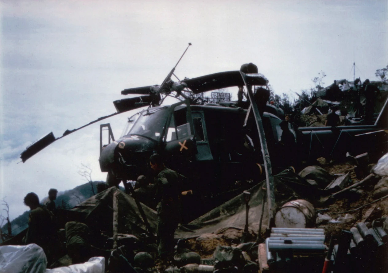
The LRRP company held Signal Hill for close to three weeks. In that time the position absorbed a series of casualties that had nothing to do with enemy fire. A helicopter crashed on the peak during a resupply run, its rotors clearing two soldiers by inches; one man was fatally crushed beneath a skid. Another soldier was struck in the chest by a fuel can flung loose in the crash. An Air Force meteorologist stationed on the hill had his leg and feet severed. The mountain itself seemed indifferent to which side it was injuring. Despite these losses, the mission continued: artillery directed, aircraft guided, wounded evacuated, intelligence relayed. The men on the summit could see the operation below them in a way that no map could replicate, and they used that vantage relentlessly.
The Price of the Valley
The full cost of Operation Delaware, for which Signal Hill was the nerve center, was significant on both sides. The 1st Cavalry Division suffered more than 130 dead and 530 wounded during the operation. Despite hundreds of B-52 strikes and jet air attacks targeting the PAVN's antiaircraft network — the most sophisticated yet encountered in South Vietnam — the North Vietnamese managed to shoot down a C-130, a CH-54 Skycrane, two CH-47 Chinooks, and nearly two dozen UH-1 Hueys, with many more damaged or lost in accidents. The PAVN's losses were heavier: more than 800 soldiers killed, along with a tank, 70 trucks, two bulldozers, 30 flamethrowers, thousands of weapons, and tons of supplies. Bad weather allowed a substantial PAVN force to withdraw into Laos before they could be encircled — a frustration that would become familiar across every operation in the A Shau.
What the LRRPs Made Possible
The Signal Hill garrison — a company-sized element of specialists trained to operate deep in enemy territory — accomplished something that larger units with heavier equipment could not: they stayed. In the thin, cool air at nearly 1,500 meters, they maintained the communications infrastructure that made coordinated air and ground operations possible, enabling timely artillery strikes and air rescues of wounded soldiers and downed aircrews throughout the valley below. Their action is largely unsung in accounts of Operation Delaware, overshadowed by the larger engagements in the valley floor. But the infantrymen below them depended on that hill's radio contact for their lives. Among the names recorded from this engagement are Pfc. Bob Noto, Sgt. William Lambert, and Pfc. James MacManus — soldiers whose service on Signal Hill cost them everything.
From the Air
Signal Hill (peak of Dong Re Lao Mountain) is located at approximately 16.3038°N, 107.2479°E on the eastern flank of the A Shau Valley, in Thừa Thiên Huế province. The summit at 4,878 ft (1,487 m) is the prominent high point on the valley's eastern rim, visible from the air as a peak distinct from the main ridge. Nearest major airport: Phu Bai International (VVPB), approximately 55 km to the northeast. From 10,000 ft approaching from the east, the A Shau Valley bottomland is visible below, with Dong Re Lao's summit on the eastern edge. Mountain weather is variable and rapidly changing; the summit is frequently in cloud.
Nearby Stories
- Bà Nà Hills 6.9 km away
- Operation Texas Star 11 km away
- Lăng Cô 15 km away
- Battle of the Mỹ Chánh Line 16 km away
- Operation Scotland II 38 km away
- Saravan 58 km away
- 1968 Kham Duc C-130 Shootdown 75 km away
- Hainan Island Incident 384 km away