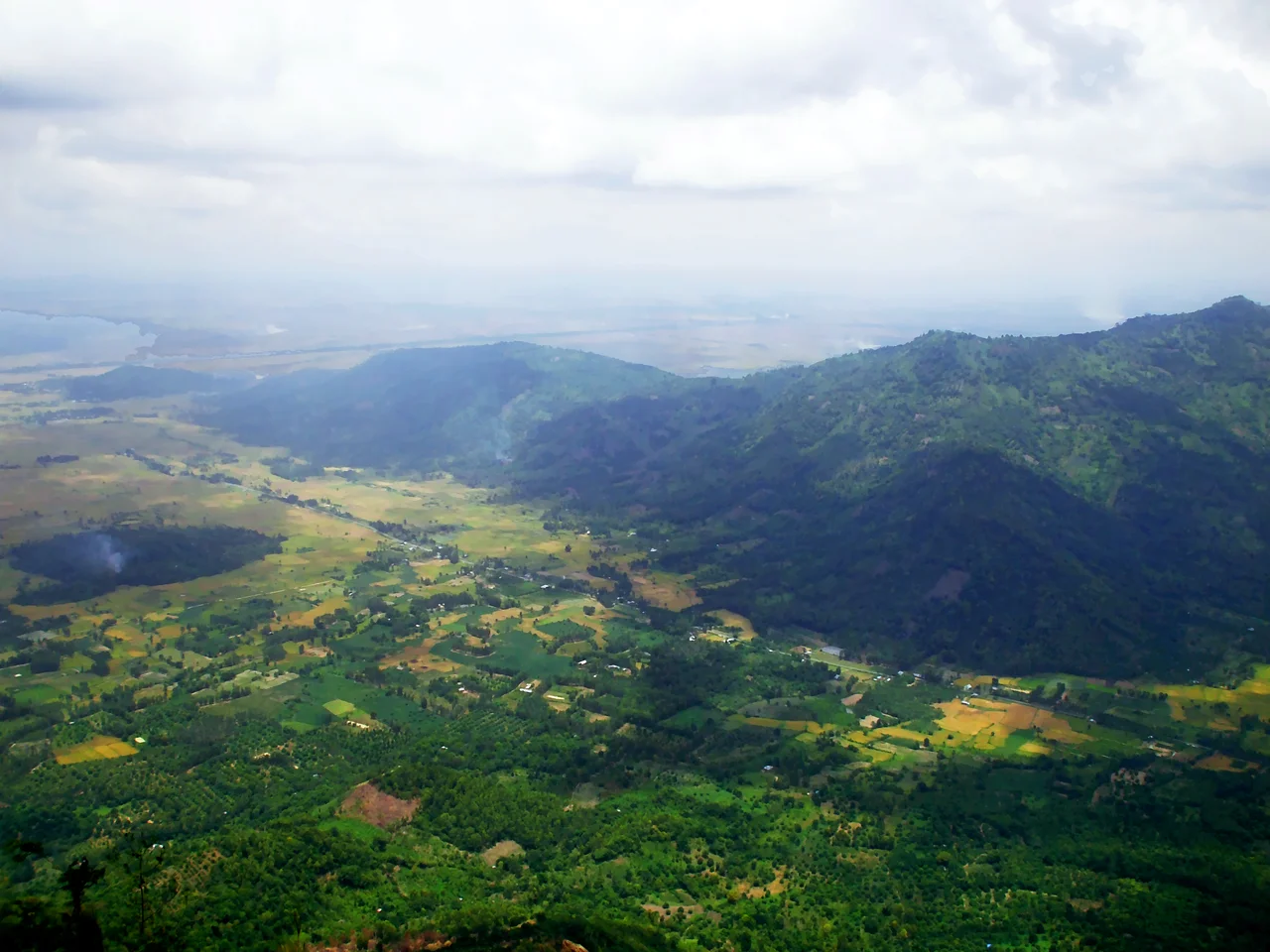

Bảy Núi
The Mekong Delta is mud. Roughly forty thousand square kilometers of river-borne silt, laid down grain by grain over millennia, so flat that a two-meter dyke counts as topography and the whole surface sits barely above the sea. Then, twenty kilometers short of the Cambodian border, seven lumps of granite break through it. They are not a range in any structural sense — they are isolated hills, remnants of much older rock the river simply buried around. Vietnamese calls them Bảy Núi, seven mountains; the Sino-Vietnamese name is Thất Sơn. In a landscape with no high ground and no caves, seven hills full of both were always going to become something more than geology.
Seven Names for Rock
Núi Cấm is the tallest, at about 710 meters, which makes it the highest point in the entire Mekong Delta and earns it the slightly overheated local nickname "the Đà Lạt of the delta" — cool air, cloud, pine-scented evenings, none of which the flatland below can offer. Núi Cô Tô reaches 614 meters, Núi Dài 580, Núi Dài Năm Giếng 265, Núi Két 225, Núi Tượng 145. And then there is Núi Nước, Water Mountain, all of twenty meters high, which in flood season disappears beneath the water entirely and re-emerges polished. Roughly three thousand people live on Núi Cấm year-round. During the pilgrimage months, from the fourth to the seventh in the lunar calendar, the hills take in something on the order of a thousand visitors a day, and the mountain roads fill with buses, motorbikes and the bull races that carry the region's name.
Why It Is Called Forbidden
Cấm means forbidden, and the standard explanation involves a fugitive. In the late eighteenth century the prince Nguyễn Ánh, pursued across the south by the Tây Sơn, is said to have hidden on this mountain. His mandarins, the story goes, sealed the approaches by putting out word that the slopes crawled with ogres, venomous snakes and worse — a rumor cheaper than a garrison and considerably more effective. Ánh survived, became Emperor Gia Long in 1802, and founded a dynasty that lasted until 1945. The mountain kept the name. Whether the tale is history or the kind of thing a landscape accumulates, it fixed something true about these hills: they were where you went when the plains were no longer safe, and people would keep proving that for the next two hundred years.
The Strange Fragrance
In 1849 a cholera epidemic tore through the delta and killed more than a million people. Out of that catastrophe came a mystic from Sa Đéc named Đoàn Minh Huyên, who was credited with healing the sick and was soon being called the Buddha Master of Western Peace. His followers wore amulets inscribed Bửu Sơn Kỳ Hương — the strange fragrance from the precious mountain — and the mountain in question was this one. To them the range is not Thất Sơn but Bửu Sơn, the Precious Mountains. The tradition took root in the soil rather than in monasteries: clear land, grow rice, owe nothing, wait for the age to turn. A disciple named Ngô Lợi carried it further, founding villages around Núi Tượng in the 1870s and raising temples there. Ninety years after Huyên, another delta prophet, Huỳnh Phú Sổ, founded Hòa Hảo Buddhism out of the same lineage. Millions of people in southern Vietnam still practice within it.
Inside the Hills
Granite gives you what silt cannot: cover. Between 1962 and 1967 Núi Dài housed the An Giang Provincial Party Committee's base, and Núi Cô Tô hid a cave large enough to serve as a weapons store and shelter for as many as 150 fighters. The stories that circulate here are the ones that stayed local. One tells of a forward platoon bombed from the air in 1969, its cave mouth collapsing with seven soldiers sealed inside; comrades pushed milk and rice porridge to them through lengths of bamboo for days before the unit was forced to give up and pull back to the U Minh forest. Nobody's account agrees on every detail. What the hills hold is not a monument but the shape of the thing itself — passages, chambers, boulder fields that swallow a person whole, and a very long habit of hiding in them.
Ba Chúc
The village of Ba Chúc sits at the foot of Núi Tượng, three kilometers from Núi Dài. Between 18 and 30 April 1978, Khmer Rouge troops crossing from Cambodia killed 3,157 civilians here. They were farmers and their families. Nguyễn Văn Kinh lost his wife, four children and six grandchildren, and got out by crawling from beneath a heap of bodies in the dark to hide in the caves on Núi Tượng. Hà Thị Nga lost everyone, including her eight-year-old daughter, who was struck three times in the head with an iron bar. People who had taken refuge in the village temple were driven into open ground and shot. An Giang built a cemetery here in 1979; a 2011 expansion covers 50,000 square meters and includes an ossuary holding the remains of 1,159 people no family ever came for, among them 1,017 skulls, sorted by age and sex. Vietnam invaded Cambodia that December. Ba Chúc is a living village now — market, school, motorbikes, rice — with the mountain behind it and the bones of a third of its 1978 population in a room at its center.
From the Air
Bảy Núi lies at roughly 10.483°N, 104.983°E in the Tri Tôn and Tịnh Biên areas of An Giang, about 20 km from the Cambodian border. This is the only significant terrain in the Mekong Delta: Núi Cấm tops out near 710 m (about 2,330 ft), so keep at least 4,500 ft MSL for terrain clearance and expect orographic cloud capping the summits in the afternoon, especially May through November. Rạch Giá Airport (VVRG) is roughly 70 km southwest, Cần Thơ International (VVCT) about 90 km east, and Phnom Penh International (VDPP) about 110 km northwest across the border. The hills are visually unmistakable from any altitude — dark green isolated domes rising abruptly out of a checkerboard of flooded paddy, with sugar palms lining the field edges. Dry-season burning from February to April can reduce slant visibility sharply.
Nearby Stories
- Kep 11 km away
- Tonle Sap–Mekong Peat Swamp Forests 23 km away
- Búng Bình Thiên 26 km away
- Collapse of Can Tho Bridge 39 km away
- Bokor National Park 45 km away
- Phú Quốc Prison 47 km away
- Battle of Tri Phap 52 km away
- Battle of Prek Klok I 116 km away