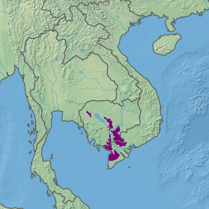

Tonle Sap–Mekong Peat Swamp Forests
Three numbers describe this place. Of the roughly 29,500 square kilometres the ecoregion covers along the Tonle Sap and Mekong floodplains, eighty-five percent has been brought under cultivation. Fifteen percent is still forested. Less than one percent has any legal protection at all. Set against most conservation writing, those figures read as a failure — and they are, if what you want is wilderness. They also describe one of the most productive agricultural systems humans have ever built, because what replaced the swamp forest is rice, and the rice feeds a very large number of people. Both things are true at once, and the tension between them is the whole story of the lower Mekong.
Water That Never Leaves
The defining feature here is not flooding but permanence. Most of the Mekong basin drains and refills on an annual rhythm — the great pulse that reverses the Tonle Sap River every monsoon and makes the lake swell to several times its dry-season size. This ecoregion is the exception: a scatter of low ground that stays underwater year-round, distinguished from the Tonle Sap freshwater swamp forests that run through the middle of it and dry out seasonally. Where water sits permanently over dead plant material, decomposition stalls for want of oxygen. Organic matter accumulates instead of vanishing. Over centuries it thickens into peat, and the ground itself becomes a slow archive of everything that ever grew on it.
Four Broken Pieces
The ecoregion is not a region so much as a scatter. Four main sectors survive. The smallest lies northwest of Tonle Sap Lake, on the outer fringe of the lake's wetlands. A second sits east of the Tonle Sap River. A third straddles the Cambodia–Vietnam border along the left bank of the Mekong, ignoring the political line entirely. The fourth spreads along the southern side of the Mekong Delta. All of them stop short of the sea — the salt-influenced coast belongs to a different ecoregion, the Indochina mangroves — so this is strictly a freshwater world, sitting on alluvial clay in a tropical savanna climate with a hard dry season and eight months of serious rain.
Paperbark
Closest to the brackish edge grow the paperbark swamps, and they are the signature habitat of the whole system. Melaleuca leucadendra, the long-leaved paperbark, is a member of the myrtle family whose bark peels away in pale papery sheets, and stands of it produce a grey-white forest of dead-looking trunks over black water. Vietnamese call these trees tràm; in English the same genus often goes by cajuput. Elsewhere the vegetation is reeds and coarse grasses on the clay flats — Phragmites karka, the hardy sugar cane Tripidium arundinaceum, the tall grain-bearing Coix gigantea. The paperbark forests have been badly reduced, but they are now the focus of active replanting, for an unsentimental reason: they hold water in the wet season and release it slowly, and a landscape this flat needs all the flood buffering it can get.
The Slivers That Remain
What protection exists comes in fragments. Parts of the ecoregion fall inside the Tonlé Sap Biosphere Reserve; Cambodia adds Borey Cholsar Wildlife Sanctuary and the Boeung Prek Lapouv Ramsar site. On the Vietnamese side, U Minh Thượng National Park holds 80.5 square kilometres of peat swamp in the southern delta, upgraded from nature reserve to national park in January 2002, later named an ASEAN Heritage Park and listed under the Ramsar Convention in April 2015. It counts 187 bird species and 32 mammals, including hairy-nosed otters. Its sister park U Minh Hạ lies nearby, and Láng Sen Wetland Reserve, Gáo Giồng and the Trà Sư cajuput forest fill in more of the map — small, scattered, and all that is left.
Bringing the Cranes Back
Tràm Chim, in Đồng Tháp province, is the case that argues for optimism. This corner of the Plain of Reeds was drained and sprayed with herbicide during the Vietnam War, and the wetland it had been did not simply recover on its own. Beginning in 1985, workers set about restoring the flooding regime — putting the water back, deliberately, on a schedule. The following year sarus cranes were recorded there, tall grey birds with scarlet heads, and the site was made a provincial reserve in 1991 specifically to keep them. It became a national park on 29 December 1998 and was designated a Ramsar wetland on 2 February 2012, receiving the number 2000 — the two-thousandth site on the global list. Seventy-six square kilometres, rebuilt from the water up.
From the Air
The ecoregion is centred loosely on 10.0°N, 105.0°E and spans roughly 29,500 km² in four disconnected sectors across Cambodia and southern Vietnam. There is nothing dramatic to see at altitude — the appeal is the pattern. From 6,000–10,000 ft the delta reads as an almost perfectly flat mosaic of rice squares laid out on a canal grid, with the surviving paperbark blocks showing as darker, shaggier rectangles against it, and the Mekong's distributaries running silt-brown through the middle. Notable fragments: U Minh Thượng National Park at about 9.58°N, 105.08°E, and Tràm Chim at about 10.72°N, 105.50°E. Nearest useful airport is Rạch Giá (VVRG), with Phú Quốc International (VVPQ) out to the west. Dry-season flying from December to March gives the clearest air; the wet months bring haze, smoke from field burning, and towering afternoon convection.
Nearby Stories
- Hà Tiên Islands 15 km away
- U Minh Thượng National Park 18 km away
- Óc Eo 25 km away
- Collapse of Can Tho Bridge 38 km away
- Sóc Trăng 40 km away
- An Thoi Naval Base 44 km away
- Battle of Tri Phap 64 km away
- Tho Chau Islands 110 km away