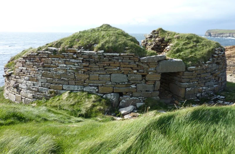

Broch of Borwick
Half of the tower is gone. The Atlantic took it, slab by slab, century by century, gnawing at the cliff until the western wall simply fell away into the surf. What remains of the Broch of Borwick stands twenty metres above the sea on a thumb of land that used to be much wider, and the part still standing is good enough to walk through. The entrance passage still has its lintels. The guard cell off the doorway is still there. Two thousand years after the people who built this place hauled their last stone into place, you can step into their threshold and look out at the same horizon they did. Then you can look down at the surf and understand that the broch is on borrowed time.
Towers Without Explanation
Brochs are unique to Scotland. There are several hundred of them scattered across the north and west, and nobody is entirely sure what they were for. The standard description calls them defensive towers, double-walled cylinders with internal galleries and a single low entrance. Borwick fits the pattern: an external diameter of seventeen metres, an internal diameter of eight, walls between three and a half and five metres thick. But brochs sit in places that would be hard to defend in any conventional sense, and many of them have been found with farming tools and looms inside. They might have been fortified farmhouses for high-status families. They might have been statements of power. The honest answer is that the people who built them did not leave instructions.
The Cliff Is Winning
Borwick stands on a promontory eight kilometres southwest of Dounby, with a small stream running past on the eastern side. The setting was probably chosen for its visibility and its natural defences. The Atlantic has spent the last two thousand years dismantling both. The western half of the broch is simply missing, eroded into the sea, and the surviving half teeters at the cliff edge. The eastern entrance passage is the best preserved part: five and a half metres long, still roofed with its original stone lintels, with grooves for a door and a small guard cell opening off to the right. Step inside and the wind drops to nothing. Step back out and the Atlantic is right there, waiting.
What Watt Found in 1881
William Graham Thomson Watt excavated the broch in 1881 and left a record of what he pulled out of the debris. The list reads like a snapshot of Iron Age daily life. Combs carved from bone or antler. A small cup made from a whale's vertebra. A spindle whorl for spinning wool. A stone gaming piece. A whetstone for sharpening blades. Hammerstones, knife blades, choppers, an iron rod, and querns for grinding grain. None of it was treasure. All of it was the kind of thing people accumulate when they live somewhere long enough to spin wool, play games, eat meals, and lose small tools in the rushes of the floor. The broch was not just a fortress. It was a home.
The Outer Wall
There used to be more than just the tower. Watt's excavation revealed an outer wall that cut Borwick off from the flat land to the east, with outbuildings filling the space between the wall and the main structure. The arrangement turned the whole promontory into a small fortified settlement, with the broch as the strongpoint and a working community around it. Most of that outer arrangement is now lost, either to erosion or to centuries of farmers harvesting building stone. What you see today is the dramatic core, isolated against the sky. What stood here in the first centuries AD was something busier and more complete.
Why It Still Matters
Orkney is broch country. The islands hold dozens of these towers, some better preserved than Borwick, some reduced to little more than a circle of stones. Borwick's contribution to the picture is its setting. Most brochs survived because they were inland and ignored. This one survived in spite of being on a clifftop directly exposed to the worst weather the Atlantic can produce. That tension between resilience and vulnerability is most of the story. The broch has lasted two thousand years, and it will not last another two thousand. Anyone who wants to see it should not wait too long.
From the Air
Broch of Borwick is at 59.03°N, 3.35°W on the west coast of the Orkney Mainland, about 4 km south of Skara Brae. Kirkwall Airport (EGPA) is roughly 25 km east, with paved facilities and limited instrument approaches. The broch sits on a 20 m clifftop promontory, best identified from 1,000 to 2,000 ft AGL by looking for a small stone ring at the very edge of the cliff with a stream running just east of the site. Westerly winds routinely produce strong updrafts and rotor against the cliff face; avoid low passes directly along the cliff line. North Atlantic weather can collapse visibility in minutes.
Nearby Stories
- Castle of Mey 9.7 km away
- Copinsay 12 km away
- HMS Sword Dance (1918) 27 km away
- Strathnaver Museum 28 km away
- HMS King Edward VII 35 km away
- Fair Isle 74 km away
- Jarlshof 135 km away
- The Laki Eruption: The Volcano That Changed World History 926 km away