.jpg)
Caiguna, Western Australia
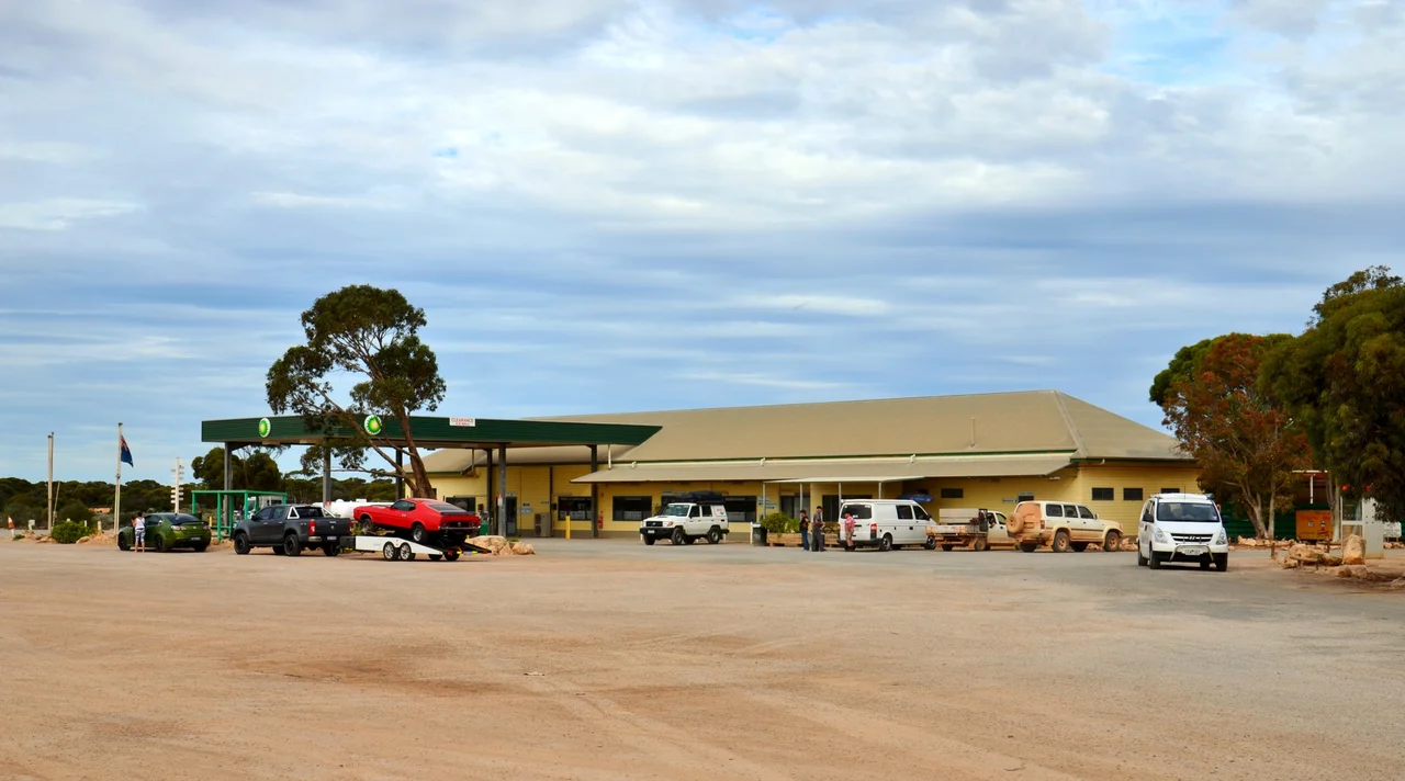
The sign at Balladonia warns you what is coming: 146.6 kilometres of road without a single bend. Drivers point the wheel east and barely touch it again for an hour and a half, the white line shimmering toward a horizon that never seems to arrive. At the far end of that ruler-straight stretch, the "90 Mile Straight," sits Caiguna, which is not really a town at all. It is a roadhouse, a fuel pump, a handful of buildings, and an enormous quantity of sky. Out here on the Nullarbor, that is enough to earn a name on the map.
Second Stop From Norseman
Caiguna is the second roadhouse east of Norseman, a way station on the long haul across the Nullarbor Plain. The name comes from an Aboriginal word thought to mean "spear track." The John Eyre Motel anchors the settlement, offering fuel, meals, a basic caravan park, and beds, and it is one of only three Nullarbor roadhouses to keep its doors open around the clock. There is even a hole of golf here: the John Eyre Motel hosts a 310-metre par-4 tee as part of the Nullarbor Links, a course so spread out that its eighteen holes stretch across more than a thousand kilometres of highway, one tee per roadhouse. Cross the country and play a round as you go.
Where the Clocks Drift
Strange things happen to time on the Nullarbor. A little east of Caiguna, the unofficial Central Western Time quietly begins, running forty-five minutes ahead of the rest of Western Australia. It is no government decree, just a practical custom adopted by the scattered communities along the road, who split the difference between the eastern and western time zones to make the long days of summer driving line up with daylight. Travellers heading for the South Australian border learn to nudge their watches forward and to stop trusting their phones, which have no signal here to argue the point anyway.
The Plain That Breathes
The flat scrubland around Caiguna hides a secret beneath its feet. The Nullarbor is honeycombed with limestone caves, hollowed out over millions of years by water dissolving the ancient seabed, and at the Caiguna Blowhole that underworld connects to the surface. Stand at the opening and you can feel air moving against your skin. When the barometric pressure outside falls, the cave exhales; when pressure rises, it inhales, drawing the surface air down into the dark. The Caiguna Blowhole breathes more vigorously than almost any cave in Australia, with gusts at the entrance clocked as high as 72 kilometres an hour. Nearby tracks lead to other rockholes and gnamma holes, the Jillbunya and Cardanumbi among them, all carved by the same patient chemistry of water and stone.
Eyre's Long Shadow
The roadhouse takes its name from Edward John Eyre, who crossed this country in 1841 and gave the great highway its name. His expedition came near here at terrible cost. On 29 April that year, two of the Aboriginal men in his party killed his overseer John Baxter and vanished into the desert with most of the supplies. Unable to bury Baxter in the solid limestone, Eyre wrapped the body in a blanket and pushed on with a young Aboriginal man named Wylie, the two of them surviving another month before a French whaling ship rescued them near Esperance. A memorial to Baxter stands about ten kilometres south of the roadhouse. The crossing that gave this place its name was paid for in loyalty and loss.
A Beacon in the Sky
For a time, Caiguna mattered to those passing overhead as much as those passing through. In the 1960s and 1970s, Ansett and Trans Australia Airlines used a radio navigation beacon here as a turning point on flights between Perth and the eastern capitals, Adelaide, Melbourne, and Sydney. A pinprick of a settlement on the empty plain became a fixed star for crews steering across a thousand kilometres of featureless ground. Bigger aircraft and better navigation eventually rerouted the airliners out over the Bight, and the sky above Caiguna fell quiet again, the way almost everything out here eventually does.
From the Air
Caiguna lies at 32.27°S, 125.49°E on the Eyre Highway, at the eastern end of the 146.6 km "90 Mile Straight." The settlement itself is a single roadhouse cluster, easy to overfly and easy to miss against the uniform scrubland of the Nullarbor Plain. Caiguna Airport (YCAG) sits just to the north, a small uncontrolled strip linked to the roadhouse by a short taxiway, elevation about 107 m (350 ft). The terrain is exceptionally flat, with the highest nearby point only 122 m. Nearest other fields are Cocklebiddy (YCKY) 63 km east and Arubiddy (YADD) 67 km. Note the unofficial Central Western Time zone east of town. Expect a dry steppe climate, mild temperatures, light traffic, and long stretches with no fuel or services in any direction.
Nearby Stories
- Twilight Cove 18 km away
- Arubiddy Station 21 km away
- Point Culver 44 km away
- Baxter Cliffs 57 km away
- Balladonia, Western Australia 91 km away
- Rawlinna Station 109 km away
- Great Australian Bight 391 km away
- Cosmo Newbery 482 km away