The Town Beneath the Water
Somewhere beneath the surface of the reservoir behind Camanche Dam lies a town that misspelled its own name. Settlers from Iowa named it Camanche in the mid-1860s, borrowing the name from their hometown -- which had itself misspelled "Comanche." The error stuck. For nearly a century, the little community on the Mokelumne River survived while bigger Gold Rush towns around it vanished. Then the East Bay Municipal Utility District came calling, and the 40 or 50 families who called Camanche home learned that their town was standing in the way of a $35 million dam vital to a $283 million water project. By 1964, the valves were closed, and the town of Camanche disappeared beneath 431,000 acre-feet of rising water.
Gold, Lime, and Irish Luck
During the California Gold Rush, the stretch of Mokelumne River that would eventually vanish under Camanche Reservoir attracted prospectors to camps with names that told their own stories: Poverty Bar, Clay's Bar, Winters Bar, and Limerick -- the last named for the Irish immigrants who flooded the area. As the easy gold played out in the mid-1860s, these camps withered. The survivors consolidated into a single settlement, and pioneers fresh from Iowa christened it Camanche. The town was never large, but it endured through decades that swallowed its neighbors. While the surrounding Sierra Nevada foothills cycled through booms and busts, Camanche quietly persisted along the Mokelumne, a minor footnote in a county that had once buzzed with forty-niners.
Taming a Dangerous River
The Mokelumne River had a destructive streak. In November 1950, flooding along the river caused approximately $1.1 million in damage. Another flood from December 1955 into January 1956 inflicted nearly $750,000 in losses. The rich croplands downstream, which depended on the river for irrigation, paid the price every time the Mokelumne swelled beyond its banks. The East Bay Municipal Utility District saw an opportunity to solve multiple problems at once: build a dam that would control flooding, regulate water flows for agriculture, and store drinking water for the growing cities across the Bay. Construction began in August 1962. The dam rose 168 feet above the streambed, stretching 2,640 feet across the canyon with a crest 34.5 feet wide. When the largest flood on record struck in December 1964 -- months after the dam's completion -- damage downstream was limited to several thousand dollars.
Engineering for the Worst Case
Camanche Dam was built to handle catastrophe. The earthfill structure uses a zoned design with an impervious core, and its engineers incorporated multiple safety features that reflected hard lessons from dam failures elsewhere. Relief wells at the base allow underground water to escape, preventing the kind of internal pressure that can undermine an earthen dam from within. The spillway alone can handle 182,000 cubic feet per second -- roughly six times the volume of the largest flood ever recorded on the reservoir. The dam controls 95 percent of the Mokelumne's 627-square-mile watershed, giving it enormous leverage over downstream flows. Since completion, those flows have remained remarkably stable: about 700 cubic feet per second during the June irrigation peak, tapering to 200-300 cubic feet per second in winter. For downstream farmers who once dreaded every heavy rain season, predictability replaced anxiety.
Poison in the Water
The dam solved the flooding problem, but it inherited another one. Northwest of Valley Springs, the abandoned Penn Mine had been leaching acid mine drainage into the Mokelumne River for years. Copper residue from the closed mine poisoned the water, killing fish and fouling the reservoir that was supposed to deliver clean drinking water to the East Bay. EBMUD and the Central Valley Regional Water Quality Control Board tried to stop the flow, but early remediation efforts backfired -- concentrations of acid drainage actually increased, and fish kills continued in the Mokelumne. The problem dragged through years of lawsuits before EBMUD and the state funded a $10 million cleanup. The remediation was finally completed in 1999, more than three decades after the dam was built.
Salmon Below the Spillway
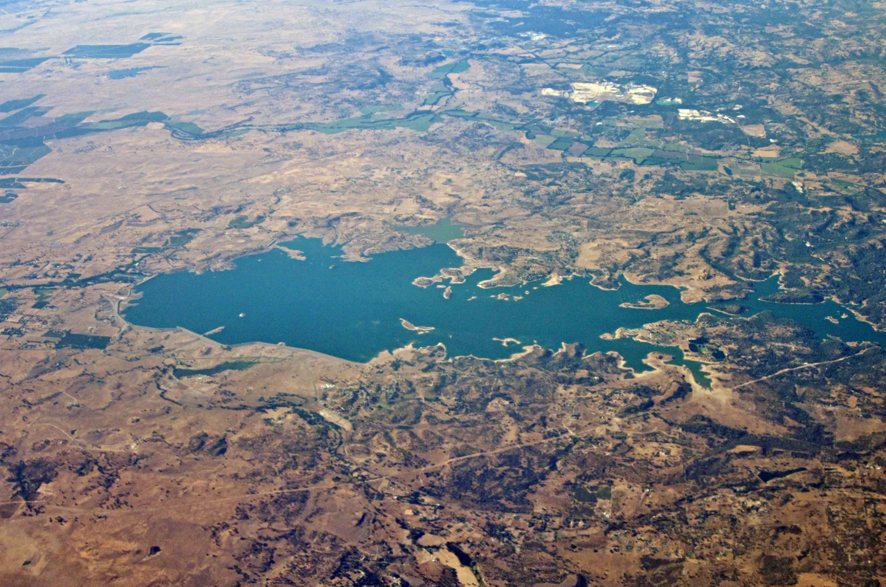
At the base of Camanche Dam, the East Bay fish facilities include what was once the largest artificial salmon spawning channel in the world -- the first of its kind in California. The channel was built to compensate for the spawning habitat the dam destroyed when it blocked the river's natural flow. Chinook salmon and steelhead trout, species that once ran freely up the Mokelumne to spawn in the Sierra foothills, now depend on the hatchery system downstream. Above the dam, the reservoir sprawls across 7,700 acres with 56 miles of shoreline, leased to the Camanche Regional Park District for recreation. Five campgrounds ring the lake, and Pardee and New Hogan lakes lie nearby. On a clear day from a few thousand feet up, the reservoir is the dominant feature of this foothill landscape -- a broad blue expanse where a town, a river, and a century of Gold Rush history lie submerged and silent.
From the Air
Camanche Dam sits at 38.2242N, 121.023W on the Mokelumne River in the Sierra Nevada foothills of San Joaquin County. The reservoir is clearly visible from altitude as a large blue body of water stretching across the foothills, with Pardee Dam and reservoir visible approximately 10 miles upstream. The nearest airport is Stockton Metropolitan Airport (KSCK), about 30 nautical miles to the southwest. Sacramento Executive Airport (KSAC) lies roughly 35 nautical miles to the northwest. The dam structure and spillway are identifiable from lower altitudes, and the contrast between the reservoir's blue water and the golden-brown oak woodland surrounding it makes for easy visual identification.
Nearby Stories
- New Melones Dam 5.6 km away
- Rio Vista, California 9 km away
- Wings Mended: The California Raptor Center 10 km away
- Emery Worldwide Airlines Flight 17 14 km away
- Black Diamond Mines Regional Preserve 19 km away
- From Aluminum to Ammunition to Aviation Fuel 33 km away
- The Emporium 34 km away
- Donner Pass 94 km away