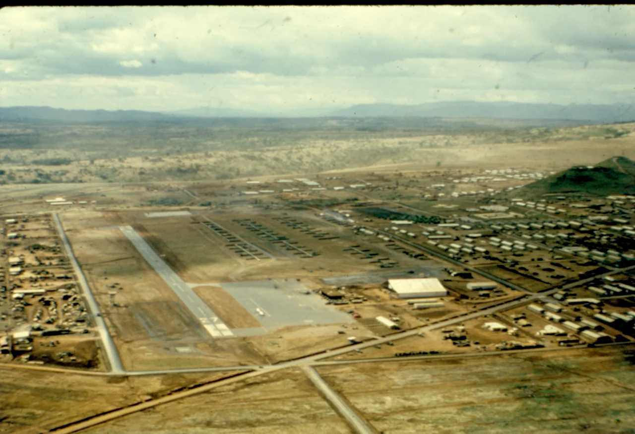

Camp Enari
Two men gave this place its names, and neither lived long enough to see it finished. The camp was named for 1st Lieutenant Mark Enari, killed on 2 December 1966 and the first soldier of the 4th Infantry Division to be awarded the Silver Star in Vietnam — awarded posthumously, which is how most such things are decided. The airstrip cut along its edge was named Hensel Airfield for Warrant Officer Ernest Hensel, a Huey gunship pilot with the 1st Squadron, 10th Cavalry, killed on 17 February 1967. Ten weeks separated their deaths. For the four years that followed, the base carried both names, and nobody who arrived there afterwards had met either man.
Below Dragon Mountain
The base sat about twelve kilometres from Pleiku along Highway 14, in the shadow of Núi Hàm Rồng — Dragon Mountain — a dormant volcanic cone rising to 1,028 metres with a crater rim for a summit. The mountain gave the camp its unofficial name, Dragon Mountain Base Camp, and gave every soldier there a fixed point on the horizon.
The ground is the deep red basalt of the Central Highlands, and it behaved in exactly two ways. In the dry season it became a fine rust-coloured dust that got into weapons, food, bedding and lungs, and turned everyone the same shade by mid-morning. In the southwest monsoon it turned to red mud deep enough to swallow a boot. Men who served at Enari tend to describe the place by its dirt before they describe anything else.
The Ivy Division Arrives
The 4th Infantry Division — the Ivy Division, from the Roman numeral IV — came ashore in Vietnam in 1966, its 2nd Brigade landing on 2 August and the division proper arriving on 25 September. Camp Enari became its home. The division held the base from September 1966 to February 1968, and again from April 1968 to February 1970, running operations across the highlands and the wider II Corps zone.
It was not quiet work. In the autumn of 1967 the division fought People's Army of Vietnam regulars in the mountains around Kon Tum, some of the heaviest sustained combat of the war in that region. Other units cycled through the base alongside it: the 2nd Squadron, 1st Cavalry, the 69th Armor Regiment, the 4th Aviation Battalion. Over its time in Vietnam the 4th Infantry Division lost 2,531 soldiers killed and had 15,229 wounded — a casualty list roughly the size of a small town, and the reason a base kept getting named after people.
Handing It Over
American withdrawal reached Camp Enari before it reached most places. On 15 April 1970 the base was turned over to South Vietnamese control, two months after the 4th Infantry Division had moved out; the division itself sailed for Fort Carson, Colorado, on 8 December 1970, with one battalion staying behind until January 1972.
What the South Vietnamese inherited was a great deal of infrastructure and a shrinking amount of support. Within five years the war in the highlands ended the way it ended everywhere — the March 1975 collapse and the retreat down Highway 7B, which began just up the road at Pleiku and became one of the war's worst civilian catastrophes.
What Grows There Now
Nothing is left. The perimeter, the bunkers, the airstrip, the water points and the endless rows of tents and hardstands have all gone back into the ground, and the land below Dragon Mountain is farmland, light industry and housing. Coffee and pepper grow on soil that was once graded flat for helicopters.
This is the ordinary fate of a war base, and it is worth sitting with. Camp Enari existed for four years. It was named for a lieutenant killed in December 1966 and an airfield named for a pilot killed ten weeks later, and the men who lived there mostly remember the red dust. The mountain that named it is unchanged and unbothered, and from its slopes the plain below looks like what it is again: good ground for growing things.
From the Air
Located at 13.867°N, 108.036°E, roughly twelve kilometres from Pleiku along Highway 14 and immediately below Núi Hàm Rồng (Dragon Mountain), which rises to 1,028 metres — the single most reliable visual landmark in the area and the feature the base was informally named for. Terrain here averages 700–800 metres, so plan minimum safe altitudes above the Hàm Rồng summit. Best viewing is 4,000–7,000 feet AGL; nothing of the base survives above ground, so look instead for the highway, the volcanic cone, and the grid of smallholdings and light industry now covering the site. Nearest airport is Pleiku (VVPK/PXU), elevation 2,441 ft, single runway 09/27 at 2,400 m, about 12 km north. Dry-season visibility from November to April is excellent; the May-to-October monsoon brings low stratus over the plateau and fast-building afternoon storms around the higher ground.
Nearby Stories
- Operation Sam Houston 20 km away
- Sê San Dam 21 km away
- Camp Radcliff 22 km away
- Operation Crazy Horse 23 km away
- Kon Tum 34 km away
- Sông Cầu 64 km away
- Buôn Hồ 78 km away
- Dak Dam 127 km away