
Kon Tum
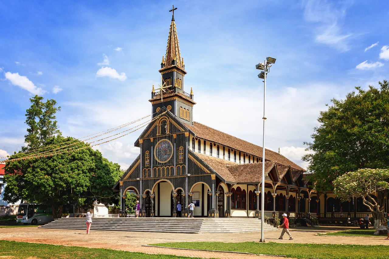
The French missionaries who arrived in the Central Highlands in the nineteenth century found something unexpected: a part of Vietnam where Catholicism took hold among the highland peoples. Churches rose in the minority villages of what would become Kon Tum Province, some of them built from local hardwood in styles that blended European ecclesiastical architecture with indigenous forms. The wooden church in Kon Tum town itself still stands, a structure that looks entirely Vietnamese in its construction methods and entirely Catholic in its purpose — a quiet monument to the particular history of this mountain region, where the boundaries between cultures have always been permeable in surprising directions.
The People the French Called Montagnards
The highlands around Kon Tum are home to several distinct ethnic groups: the Bahnar, Sedang, Jarai, Gieh Trieng, Rengao, and others. The French called all of them montagnards — mountain people — a collective term that flattened distinctions between groups with different languages, traditions, and histories. Each group has its own identity, its own ceremonies, its own relationship to the land. What they share is the rong: the communal house, built on stilts with a dramatically steep thatched roof that can rise 10 or 15 meters above the village floor. The rong is where the community meets for important occasions — harvests, festivals, conflict resolution, the reception of guests. To enter a Bahnar village and see the rong at its center is to understand that these communities have architectural and social traditions of considerable sophistication, developed over centuries in the highlands they have occupied since before recorded history began in this part of the world.
The Ho Chi Minh Trail's Hidden Spine
Highway 14 runs through Kon Tum, connecting the coast at Da Nang to the Mekong lowlands in the south. The road follows the same inland corridor that formed the northern section of the Ho Chi Minh Trail — the supply network that North Vietnam used to move soldiers and materiel southward during the Vietnam War, threading through some of the most rugged jungle terrain in the country. The Trail was not a single road but a shifting network of paths, tunnels, river crossings, and rest stations, constantly adapted in response to American air power. Portions of it ran through the highlands west of Kon Tum, and the region saw sustained fighting. Today the highway is a legitimate road — upgraded, busier than it once was — and the jungle has grown back over most of what the war left behind. The mountains on both sides of the pass between Kon Tum and the coast remain dense and largely unpopulated.
Two Traditions, Side by Side
Walking through Kon Tum town, you encounter the Catholic legacy directly — the wooden church, mission buildings, the presence of a Vietnamese Catholic community alongside the Buddhist majority and the animist highland peoples outside town. The missionaries who came here in the 19th century faced a terrain that was difficult to reach and a population that spoke many different languages. Their relative success in converting some of the highland minorities created a cultural configuration that persists: Bahnar villages where Catholic and animist traditions coexist, where the church stands near the rong rather than replacing it. This is different from the lowland Vietnamese experience of Catholicism, which arrived under French colonial authority in a context of explicit political pressure. In the highlands, the religion spread through sustained personal presence in difficult conditions, and its roots feel correspondingly deeper.
Garden Cafes and the Slowness of the Place
Kon Tum is a small town with a large quiet. The street food is concentrated along Tran Phu, around the market, and on the road that runs parallel to the Dak Bla River — the usual Vietnamese fare of pho and rice dishes, with a small vegetarian restaurant tucked away on a side street that serves dishes made from faux-meat with such conviction that the distinctions matter less than the taste. The garden cafes that appear throughout the town are a genuine pleasure: open-air spaces with trees and shade and the unhurried pace of a provincial city that has no particular reason to hurry. Da Nang is 200 kilometers away by road, but feels further. The highlands generate their own sense of time, cooler and less pressured than the coast, and Kon Tum moves at the highlands' speed.
A Gateway That Requires a Guide
The minority villages around Kon Tum are the primary reason most visitors make the effort to reach the town — but they are not places to enter unannounced. Each village has its own protocols, its own taboos, its own relationship to outside visitors, and the assumption that curiosity justifies intrusion is one the minority peoples have learned to be wary of. Going with a local guide who speaks the minority language is not just practical but respectful: it signals an intention to engage on the community's terms rather than as a spectator. The Sedang, Bahnar, and Jarai have maintained their cultures through centuries of pressure — from the Cham, from the Vietnamese, from the French, from the American war, from development. They are not museum exhibits. They are living communities with their own ongoing life, and the rong still holds the village together.
From the Air
Kon Tum sits at 14.34°N, 107.98°E in Vietnam's Central Highlands, at an elevation of approximately 525 meters above sea level. From altitude, the highlands plateau is visible as a broad elevated region west of the coastal mountains, the Dak Bla River threading through the town before joining the Krong Po Ko River downstream. The Annamite Range forms a dramatic east-west divide between the highlands and the coastal plain, visible as a spine of dark forested ridges. Recommended viewing altitude 6,000–10,000 feet for the full highlands context. The nearest commercial airport is Pleiku Airport (VVPK), approximately 50 km southwest. Da Nang International Airport (VVDN) lies approximately 200 km to the northeast via the mountain pass.
Nearby Stories
- Siege of Đắk Đoa 7.7 km away
- Camp Radcliff 7.9 km away
- Sê San Dam 14 km away
- Măng Đen 20 km away
- Firebase Bird 28 km away
- Operation Sam Houston 35 km away
- Dong Ampham National Biodiversity Conservation Area 60 km away
- Quảng Ngãi 61 km away