Clear Lake: California's Ancient Inland Sea
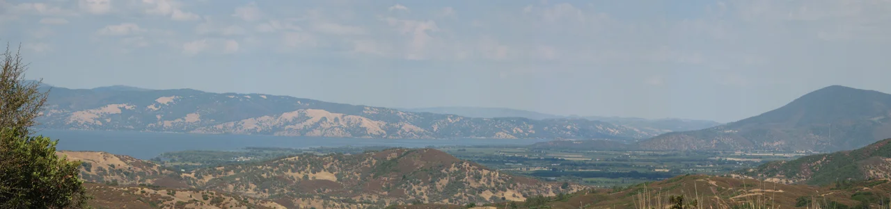
The name is a lie, and everyone who lives here knows it. Clear Lake has not been clear for decades. Algal blooms cloud the water green each summer, mercury from an abandoned mine taints the fish, and the lake that Rachel Carson wrote about in Silent Spring still carries the chemical legacy of a mid-century war against gnats. Yet this murky, complicated body of water is also the oldest natural lake in North America, nearly half a million years old, sitting in a basin where lakes have formed and reformed for 2.5 million years. At 68 square miles, it is the largest natural freshwater lake entirely within California, and it remains, despite everything done to it, a place of extraordinary ecological richness.
A Basin That Refuses to Die
Most lakes are geologically temporary. They fill with sediment, drain through shifting outlets, and vanish within tens of thousands of years. Clear Lake has persisted for roughly 480,000 years because of a geological trick: the massive block of rock beneath it tilts slowly northward at the same rate the lake fills with sediment, keeping the water at roughly the same depth. Core samples taken by USGS geologists in 1973 and 1980 revealed this extraordinary longevity. The lake sits within the Clear Lake Volcanic Field, where eruptions and landslides have reshaped the landscape repeatedly, at one point severing the lake from the nearby Blue Lakes and redirecting its drainage from the Russian River to Cache Creek. Three arms spread across the basin: the Upper Arm, the Oaks Arm, and the Lower Arm. Cache Creek, the only outlet, flows from the Lower Arm through a canyon where a large colony of bald eagles nests.
Eleven Thousand Years of Habitation
Archaeological evidence places human occupation of the Clear Lake basin at least 11,000 years into the past. The Pomo, Lake Miwok, and Wappo peoples built their lives around the lake's abundance. The Pomo called it Hok-has-ha. They wove tule grass into cooking baskets, fishing nets, boats, shelters, and dance regalia. The lake's native fish, the Clear Lake hitch, which the Pomo called chi, spawned in such numbers that its runs were a cornerstone of the food supply. European American settlers arrived in the 1840s and renamed the lake, first as Big Lake, then Laguna, before settling on Clear Lake by mid-century. The settlers brought violence. Andrew Kelsey and Charles Stone forced local Pomo into servitude, paying labor with lashes. When the Pomo killed their captors in 1849, the U.S. Army retaliated. On May 15, 1850, soldiers under Lieutenant Nathaniel Lyon cornered Pomo families on an island called Bo-no-po-ti and slaughtered as many as 200 people, mostly women and children. The Bloody Island Massacre remains one of the defining tragedies of California's indigenous past.
Silent Spring's Proving Ground
In the 1940s, Clear Lake's phantom midges swarmed so thickly that lakeside resorts complained about losing business. The gnats did not bite, but they arrived in clouds. In 1949, authorities applied DDD, a pesticide related to DDT, directly to the lake. The gnats died. So did the western grebes. The elegant diving birds absorbed the pesticide through the fish they ate, concentrations magnifying at each step of the food chain. By the late 1950s, the grebe population had collapsed. Rachel Carson documented the Clear Lake case in Silent Spring, published in 1962, using it as evidence of how pesticides accumulate through ecosystems. The lake became one of the foundational examples of bioaccumulation in environmental science. Meanwhile, mercury from the Sulphur Bank Mercury Mine on the eastern shore was leaching into the sediment. The mine was declared a Superfund site in the early 1990s and cleanup continues today. Blood tests on Pomo tribal members in the early 1990s found mercury levels twice the expected baseline.
Water Wars on the Rumsey Gauge
In 1872, a cattle drive captain named DeWitt Clinton Rumsey installed a gauge in Lakeport to measure water level. He defined zero as the point where water stopped flowing over a rocky ledge in Cache Creek called the Grigsby Riffle. That gauge, now automated, still operates. Yolo County acquired riparian rights in 1855 and built a dam in 1914, gaining control over the lake's only outlet. Court decrees in 1920 and 1942 set the normal maximum at 7.56 feet Rumsey. If the lake is full on May 1, Yolo County can draw 150,000 acre-feet. If it falls below 3.22 feet, they draw nothing. The highest recorded level, 13.66 feet, came in 1890. The lowest arrived in 1920. A 1991 court ruling established that zero feet Rumsey marks the official low-water line for property ownership, settling decades of disputes over shifting shorelines.
A Lake Between Ruin and Restoration
Clear Lake today is a place of contradictions. Over 100 miles of shoreline draw 15,000 boaters a year, and the lake hosts the oldest and largest seaplane splash-in in the western United States. Tule elk, hunted to local extinction a century ago, have been reintroduced and are growing in number. Yet the lake remains listed as an impaired water body under the Clean Water Act. Algal blooms fueled by phosphorus runoff produce mats of scum each summer. Historic wetlands have been reduced by 79 percent. Invasive hydrilla chokes native vegetation. In 2009, Governor Schwarzenegger signed legislation to breach levees and restore 1,650 acres of lake and wetland, a project that would also make Bloody Island an island again. A Blue Ribbon Committee and a Cyanobacteria Task Force, which includes four Pomo tribes, now work to rehabilitate the ecosystem. The oldest lake in North America is still fighting for its future.
From the Air
Clear Lake sits at 39.06N, 122.83W in Lake County, California, at an elevation of approximately 1,318 feet. The lake's three arms are clearly visible from altitude, with Mount Konocti (4,299 feet) rising prominently on the southern shore. Best viewed from 3,000-5,000 feet AGL for the full basin perspective. The nearest airports are Lampson Field (1O2) in Lakeport on the western shore and Ukiah Municipal Airport (KUKI) approximately 20 nautical miles to the west. Summer temperatures frequently exceed 100 degrees F, and afternoon haze from algal blooms can affect visibility over the water.
Nearby Stories
- The Valley That Invented Its Own Language 6.3 km away
- Bottle Rock Power Plant 9 km away
- Gualala River 15 km away
- Yocha Dehe Wintun Nation 22 km away
- Rico Harris 23 km away
- August Complex Fire 47 km away
- Bidwell Mansion State Historic Park 59 km away
- Fort Gaston 188 km away