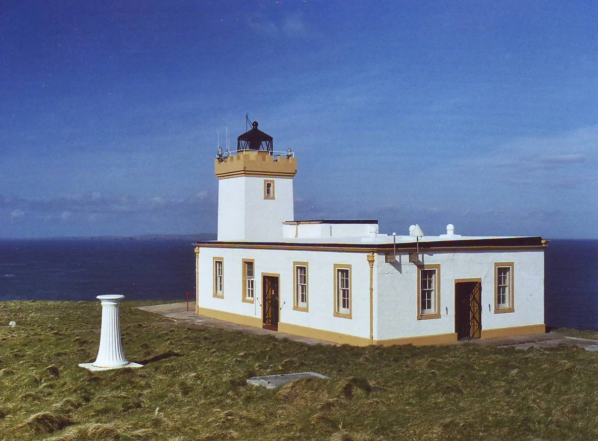

Duncansby Head
In 1953 someone seriously proposed dropping an atomic bomb here. Scientists from the Atomic Weapons Establishment at Aldermaston looked at the Stacks of Duncansby - tall sandstone pyramids jutting from the North Sea at the very northeast corner of Britain - and decided they would make a fine test target. The wet weather killed the plan. The electronics of the day could not cope with the spray and drizzle that defines this headland for most of the year, and the idea was shelved. The stacks survived. The lighthouse survived. The puffins, mercifully, never knew how close they came.
The Far Corner
Duncansby Head is the northeastern tip of the British mainland - not the most northerly point, which belongs to Dunnet Head 12 miles to the west, but the corner where the country runs out to the east. Beyond is the Pentland Firth to the north, the Moray Firth to the south, the North Sea straight ahead, and Orkney just visible across the water. The minor road from John o' Groats ends here. That single fact gives the headland its other distinction: it is the farthest point by road from Land's End, and so the unofficial alternate finish line for anyone walking, cycling or otherwise propelling themselves up the length of Britain. The cliffs drop to a sea that rarely sits still.
The Stevenson Light
The lighthouse on the headland was built in 1924 by David Alan Stevenson, the last working lighthouse engineer of the famous Edinburgh family that also produced Robert Louis Stevenson - the writer who got the easier job. The tower is white, square in plan, squat compared to the towering pylons further south, and sits low on the clifftop because the cliffs themselves do most of the work. In 2024 it marked its centenary. The keepers' cottages have been removed and the light runs on solar power now, automated and unattended, but it still flashes for shipping in the Pentland Firth - one of the busiest and most dangerous tidal channels in the world.
Stacks Like Sentinels
Walk south from the lighthouse along the clifftop path and the Stacks of Duncansby appear. Three tall, almost-pyramidal pinnacles of Old Red Sandstone standing offshore, sheared from the cliff by millions of years of wave attack and finally left isolated as the headland retreated. The largest is around 60 metres tall. They look like cathedral spires that someone tried to anchor at sea. The whole 6.5 kilometre stretch of coast south to Skirza Head is a Site of Special Scientific Interest, riddled with geos (narrow inlets where the sea has eaten back along a fault), sea caves, and blowholes. The geology is the show. The wildlife is the encore.
The Seabird City
In spring and summer the cliffs erupt into noise. Puffins return from their winter at sea to dig burrows in the turf above the cliff edge - the famous orange beaks glowing absurdly against the green grass. Guillemots and razorbills pack the ledges in dense rows, neighbours touching, the constant chuntering chorus rising and falling with the wind. Kittiwakes wheel below in white flocks, calling their own name. In the waters offshore, grey seals haul out on the rocks at the foot of the stacks, harbour porpoises break the surface in quick black arcs, and minke whales sometimes pass through. The smell - a heady mix of ammonia, fish and salt - is so strong it carries on the breeze long before you see the birds themselves.
Ghost Ships and Old Stories
The Pentland Firth has long carried its own folklore. The tide race here - where the Atlantic floods and drains the North Sea twice a day - can run at 12 knots, fast enough to overwhelm small boats and confuse even big ones. Sailors spoke of the Men of Mey, columns of standing water that rear up when wind meets tide. They told of ghost ships seen at dawn, gone by full light. Duncansby Head's lonely position has attached itself to many of these stories - the last point of land before the open sea, the place from which the lighthouse keepers watched whatever passed in the dark. Poets and painters have come up here to try to render it. Most of them have left grateful for the warmth of a hotel room and the firm ground of John o' Groats two miles away.
From the Air
Located at 58.6444 N, 3.02444 W - the northeastern tip of mainland Britain. The Duncansby Head Lighthouse (active, white square tower, 11 metres) is the obvious visual marker. The three Stacks of Duncansby rise just south of the headland, the tallest around 60 metres - useful waypoints from low altitude. Wick John O'Groats Airport (ICAO: EGPC) lies 14 nautical miles south; Kirkwall (ICAO: EGPA) is 22 nautical miles north across the Pentland Firth. Approaches from the south follow the cliff line past John o' Groats village. Recommended viewing altitude 1,000-2,500 feet for the stacks and seabird cliffs. The Pentland Firth tide race below produces visible standing waves and overfalls, especially during wind-over-tide conditions - a striking sight from above. Watch for sudden sea fog (haar) from the North Sea; Wick weather often differs from Kirkwall by minutes.
Nearby Stories
- Thurso 3 km away
- Scapa Flow 3.8 km away
- Hill o' Many Stanes 13 km away
- Dunbeath Air Crash 14 km away
- HMS Daring (H16) 41 km away
- German submarine U-58 (1938) 52 km away
- Orcadian Basin 57 km away
- The Laki Eruption: The Volcano That Changed World History 967 km away