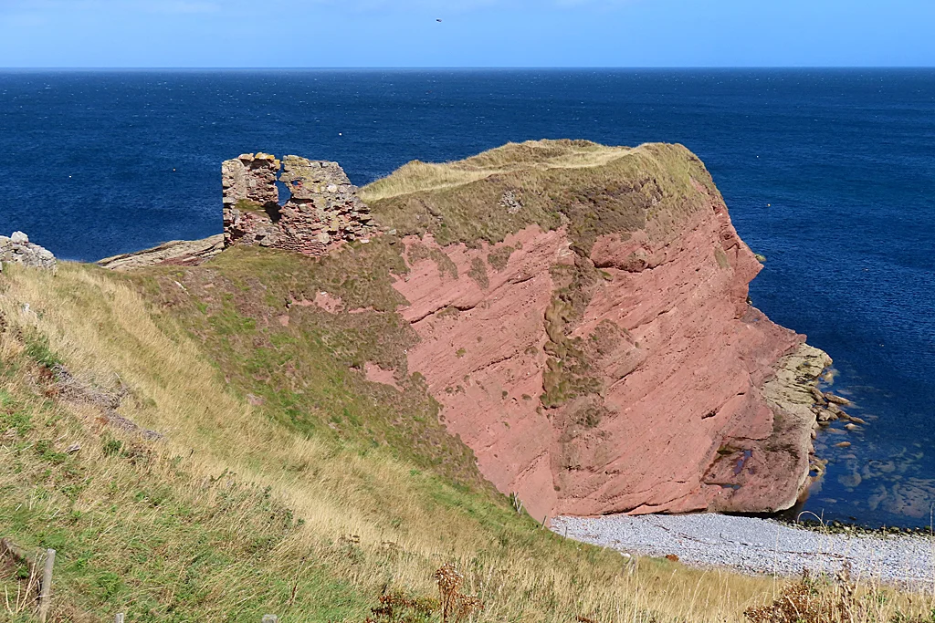

Dundarg Castle
Dun dearg. Red fort. The Gaelic name names the stone - the warm reddish sandstone of this North-East Aberdeenshire headland, cliffs twenty metres high on three sides, the North Sea beating at their base. Charles McKean called Dundarg Castle Scotland's answer to Tintagel, and the comparison fits more than the architecture: both are dramatic clifftop seats that have lived through more histories than any single ruin should reasonably hold. W. Douglas Simpson named Dundarg one of the nine castles of the Knuckle - that rocky north-east elbow of Aberdeenshire where the coast turns south toward the gannet colonies of Troup Head.
Layers Older Than Stone Walls
Before any castle, there was an Iron Age promontory fort here. The triangle of gently sloping ground at the headland's neck, flanked by steep falls and joined to a flat-topped extension running out to sea, is exactly the shape of land Iron Age communities chose for defence. The 10th-century Book of Deer - the oldest surviving manuscript written wholly or partly in Scotland - records the existence of a cathair, a fortified place, at Aberdour. For a time the site held a small Celtic monastery, the kind of cliff-edge community where prayer and the sound of the sea ran together. The medieval castle built later sat down on top of all of it.
The Comyns and the Bruce
In the 13th century the Comyn family - one of the most powerful kindreds in pre-Bruce Scotland - built the castle. The Comyns lost everything in the wars of independence. Robert the Bruce dismantled Dundarg in 1308, almost certainly during the campaign that broke Comyn power in the north. The walls came down. The headland went quiet for a generation. Then in 1334 Alice Comyn, Countess of Buchan, and her husband Henry de Beaumont rebuilt it - briefly, defiantly, as a base for the disinherited lords trying to claw back what Bruce had taken. They had been there only months when Sir Andrew Moray laid siege to it. He took it. He slighted it. The walls came down a second time.
What the Excavations Showed
W. Douglas Simpson led excavations here in 1911-12 and again in 1950-51. He found medieval objects layered in the rubble - evidence not of one destruction but two, the work of Bruce's men over the work of Comyn builders, then Moray's destruction over Beaumont's hurried 1334 rebuild. The inner gatehouse still stands to about eighteen feet, the only substantial part of the castle still upright. Its upper section was rebuilt in the mid-16th century, probably under the Coastal Defence Commission of 1550 when fears of a French invasion sent surveyors round the Scottish coast checking which headlands could be made defensible. There is evidence the rebuilt gatehouse was fitted with gunloops - the narrow stone slits cut for hand cannon and musket fire.
The Modern House on the Bailey
The site was finally abandoned in the mid-17th century. For nearly three centuries the headland was left to grass and gulls. Then in 1938 Wing Commander David Vaughan Carnegie built himself a house on part of the old castle ground, using stone reportedly salvaged from the demolished Aberdour Free Church. That house is now itself a Category B listed building - quirky, unmistakably 20th century, sitting in the lee of medieval ruins on top of an Iron Age fort. Few houses in Scotland have a longer chain of predecessors. From the air the modern roof reads first; only when you look harder do the earthworks and the gatehouse emerge from the grass.
Standing on the Headland
Reach the site by foot from New Aberdour, two kilometres south-west - the village whose church gave Dundarg its stone. The cliffs to either side of the castle drop straight to dark sandstone shelves and a foaming surf. Northward there is only sea, all the way to the Pentland Firth and the open Atlantic beyond. The Knuckle's other castles - Pitsligo, Pitullie, Kinnaird, Wine Tower, Cairnbulg, Inverallochy, Lonmay and Rattray - are scattered along the same coast, each on its own headland, each guarding its own arc of water. None has Dundarg's layering. None has its red stone catching the late sun the way the Gaelic name promised it would, the way the Comyns and Beaumonts and Bruces all saw it before they came and went.
From the Air
Dundarg Castle stands at 57.6733 N, 2.1780 W on a sandstone headland about 2 km north-northeast of New Aberdour. From cruise altitude the site appears as a small triangular promontory on the Aberdeenshire coast roughly between Macduff and Fraserburgh. Nearest major airport is Aberdeen (EGPD) about 35 nm to the south-east; RAF Lossiemouth (EGQS) lies west. Best viewed in low oblique sun when the red sandstone and earthworks stand out from the grass.
Nearby Stories
- Cullen Viaduct 5.9 km away
- Fyvie Castle 7.8 km away
- Auchindoun Castle 18 km away
- German submarine U-58 (1938) 27 km away
- HMS Exmouth (H02) 35 km away
- Hill o' Many Stanes 42 km away
- HMS Daring (H16) 99 km away
- Longstone Lighthouse 204 km away