A Dam Built for Ghosts
The Army Corps of Engineers built Englebright Dam in 1941 to solve a problem that technically no longer existed. Hydraulic mining -- the practice of blasting hillsides apart with high-pressure water cannons to extract gold -- had been halted in the Sierra Nevada in 1884, outlawed by a federal court after downstream farmers watched their fields drown in mining debris. Yet the sediment kept coming. Decades of devastation had left the Yuba River watershed so scarred that old mine sites continued shedding gravel and silt long after the monitors went silent. Englebright was built to catch the runoff of an industry already dead, a concrete arch plugging a gorge to hold back the consequences of the Gold Rush.
The Debris Wars
The story behind Englebright Dam begins not with engineering but with conflict. Hydraulic mining transformed the Sierra foothills in the 1850s and 1860s, washing entire mountainsides into flumes and sluice boxes. The tailings -- billions of cubic yards of gravel, sand, and clay -- flowed downstream into the Yuba, the Bear, and the Feather rivers, raising riverbeds, flooding farms, and burying entire towns in the Sacramento Valley. Farmers organized, sued, and in 1884 won the landmark Sawyer Decision, which effectively banned hydraulic mining. But the damage was done. The California Debris Commission, created to manage the aftermath, allowed limited hydraulic mining to resume during the Great Depression under strict controls. Englebright Dam was the commission's final answer: a permanent sediment trap in the narrow gorge known as the Narrows, where the Yuba cuts through bedrock east of Marysville.
Concrete in the Narrows
The dam itself is a variable-radius concrete arch, 260 feet high and 1,142 feet across, curved to press its load into the canyon walls. Behind it, the Yuba backs up into a nine-mile-long reservoir with 815 acres of surface area and roughly 70,000 acre-feet of capacity. The gorge is steep enough that Englebright Lake has no shoreline roads, no drive-up campgrounds, no lakeside picnic tables. The only way to camp here is by boat. That isolation gives the lake a character unusual for California reservoirs -- quiet, unhurried, hemmed in by pine and oak on slopes too steep for development. Two powerhouses generate electricity from the dam's releases: Narrows II at the base of the dam and the smaller Narrows I further downstream. Together, they produce roughly 294 million kilowatt-hours per year, enough to power about 50,000 homes.
Water for a Valley
Englebright's original purpose -- sediment storage -- is now almost incidental to its daily role. Of the reservoir's total capacity, 45,000 acre-feet of stored water is released annually through dam operations to benefit fish populations downstream in the lower Yuba River, one of the last remaining runs of spring-run Chinook salmon in the Central Valley. Additional water is diverted for domestic and agricultural use across the region. In 2006, the Yuba County Water Agency installed a flow bypass system so that downstream river requirements could still be met during shutdowns of the Narrows II Powerhouse -- a recognition that the dam, originally built to hold back debris, had become a critical node in the water supply of the Sacramento Valley. The sediment it was designed to catch still accumulates behind the dam, slowly reducing its storage capacity, an unresolved legacy of the hydraulic mining era.
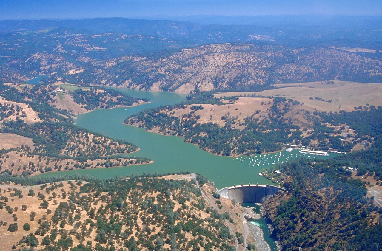
The View from Above
From the air, Englebright Lake is a thin blue finger reaching into the Sierra foothills, its shape dictated entirely by the contours of the Yuba River gorge. The concrete arc of the dam stands out against the dark canyon rock, with the powerhouse structures visible at its base. The lake's boat-in-only access means there are no marinas or parking lots cluttering the shoreline -- just forested slopes dropping steeply to water. It is an oddly peaceful place for something born out of environmental catastrophe. The mining scars that created the need for this dam are largely invisible now, healed over by a century and a half of regrowth. But the sediment is still down there, compacting slowly behind 260 feet of concrete, the compressed remains of mountains that were washed away for gold.
From the Air
Located at 39.240N, 121.269W in the Yuba River gorge, on the border of Yuba and Nevada counties, California. The concrete arch dam and narrow reservoir are clearly visible from altitude -- look for a thin, sinuous lake with steep forested shorelines and no road access. The dam structure and powerhouses at its base are identifiable below 5,000 feet AGL. Nearest airports: Beale AFB (KBAB, approximately 15 nm southwest), Nevada County Air Park (GOO, approximately 15 nm east). Marysville is visible to the west in the Sacramento Valley.
Nearby Stories
- The Hospital That Became a County 9.3 km away
- The Middle Mountains Nobody Can Reach 16 km away
- The Yuba County Five 18 km away
- Honey Run Covered Bridge 21 km away
- Western Pacific Railroad Museum 30 km away
- Griffith Mansion 36 km away
- New Melones Dam 120 km away