Ferguson Fire
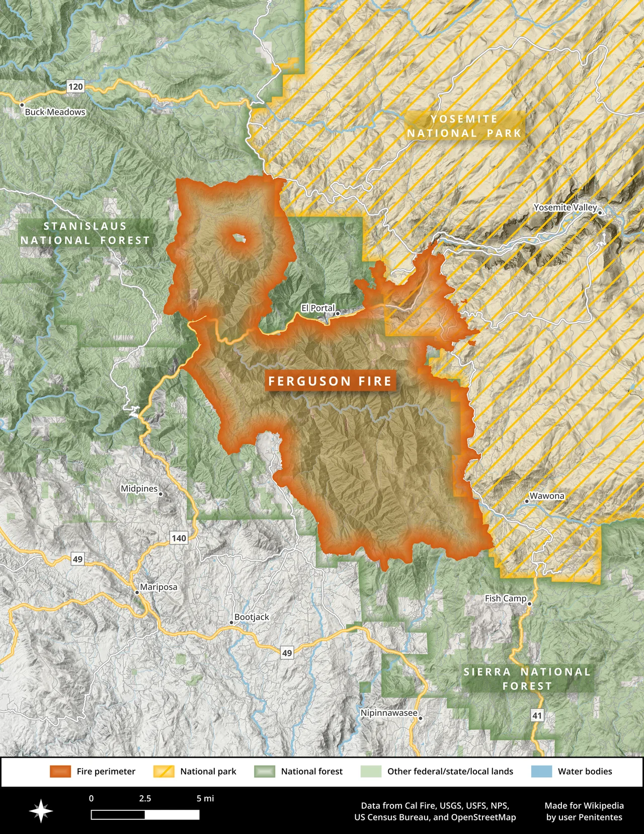
On July 20, 2018, the Ferguson Fire jumped the Merced River. Until that moment, firefighters had hoped the river would serve as a natural barrier, holding the blaze to the south side of the canyon. Instead, burning embers sailed across the water and ignited spot fires near Miller Gulch and Ned Gulch in the Stanislaus National Forest, consuming an estimated 600 acres in hours. The fire had been burning for a week already, reported on July 13 in the Sierra National Forest, and it would not be declared inactive until September 19. In that span, it burned 96,901 acres across three national forests and Yosemite National Park, forced the unprecedented closure of Yosemite Valley, killed two firefighters, and cost more than $100 million to fight.
A Week of Losing Ground
The Ferguson Fire grew with a relentlessness that made each day's containment figures feel like fiction. On July 15, it covered 4,310 acres. By July 18, it had quadrupled to over 17,000. Electricity failed in portions of Yosemite National Park. The Red Cross opened a shelter at a church in Mariposa. Mandatory evacuations cascaded through communities with names that sound pastoral until fire gives them urgency: Jerseydale, Sweetwater Ridge, Mariposa Pines. Crews focused on indirect containment lines - firebreaks built at a distance from the active flames, in terrain so rugged that both ground and air crews struggled to make progress. The fire moved toward Highway 140, the primary western approach to Yosemite, and by July 17 the park's western entrance was closed. For a fire named after the ridge where it started, Ferguson showed little loyalty to any single piece of geography.
The Day Yosemite Closed
On July 24, the National Park Service announced that Yosemite Valley and Wawona would close by noon the following day. It was an extraordinary step. Yosemite Valley - the most visited seven square miles of wilderness in America - was being evacuated. Visitors and residents were ordered out. Mariposa Grove, home to some of the planet's oldest living things, was shuttered. At nearly 4,000 personnel, the firefighting force had grown to the size of a small town, and still the fire outpaced them. By July 31, it had consumed 58,074 acres and was only 33 percent contained. Beetle-killed trees, standing dead and dry, made entire slopes into ready fuel, and the terrain near El Portal was so difficult to access that crews resorted to fire retardant and water drops while searching for any viable path to build containment lines on the ground.
Braden Varney and Brian Hughes
Braden Varney was a bulldozer operator with the California Department of Forestry and Fire Protection. During operations on the Ferguson Fire, his vehicle rolled down a ravine, killing him. He was the fire's first fatality. On July 29, Brian Hughes, captain of the Arrowhead Interagency Hotshots, was struck and killed by a falling tree. Hughes was one of the elite wildland firefighters who walk into the places where fire burns hottest, cutting line by hand in terrain too steep or too dense for machinery. Nineteen other firefighters were injured during the Ferguson Fire, including several who suffered back injuries and required hospitalization. These are not statistics. Varney and Hughes went to work in a burning forest and did not come home, and the communities they were trying to protect - El Portal, Wawona, Yosemite West - owe a debt that no memorial can fully repay.
Containment by Degrees
Firefighters do not extinguish a fire of this scale. They surround it. Containment lines were built from Jerseydale to Wawona Campground, from Five Corners to Pilot Peak, from Henness Ridge southeast to Highway 41. When the fire jumped a line near El Portal, crews used indirect methods to intercept it. When spot fires appeared near Wawona, they were contained overnight. The fire linked to burn scars from the 2017 Empire Fire and South Fork Fire, creating a patchwork of old and new devastation. By August 6, 94,331 acres had burned and containment stood at 39 percent. Full containment came on August 19 at 96,901 acres, but interior areas continued to smolder into September. On September 19, InciWeb declared the fire inactive. The word sounds clinical. What it means is that after 68 days, the Ferguson Fire had finally run out of things to burn.
What Fire Leaves Behind
Yosemite Valley reopened on August 5, though Wawona Road and the Mariposa Grove of Giant Sequoias remained closed longer. The economic impact rippled outward from the park through gateway communities that depend on summer tourism for their survival. But the Ferguson Fire also forced a reckoning with the reality that California's forests are changing. Decades of fire suppression had left the Sierra Nevada loaded with fuel. Bark beetle infestations, worsened by drought, had killed millions of trees. The conditions that produced the Ferguson Fire were not anomalous - they were the new baseline. In the years since, other fires have dwarfed the Ferguson in acreage, but few have struck quite the same nerve. When Yosemite Valley closes, the nation pays attention. The Ferguson Fire made visible what foresters had been warning about for years: the forests of the Sierra Nevada were burning on a scale that no amount of personnel or machinery could reliably control.
From the Air
Located at 37.652°N, 119.881°W in the Sierra National Forest west of Yosemite National Park. The fire's burn scar extends across a vast area between the Merced River canyon and the Chowchilla Mountains, visible from the air as lighter-colored terrain with regenerating vegetation. Best viewed at 5,000-8,000 ft AGL. Nearest airports: Fresno Yosemite International (FAT), approximately 55 miles south; Mariposa-Yosemite Airport (MPI), roughly 20 miles west. Caution: mountainous terrain with variable winds; smoke haze possible during fire season.
Nearby Stories
- Lake McClure 8.1 km away
- Mono Lake 16 km away
- Bass Lake 18 km away
- Fifteen Minutes at UC Merced 19 km away
- Mono Lake: Where Salt Towers Rise From Dying Water 36 km away
- Indian Grinding Rock State Historic Park 62 km away
- Bodie Ghost Town 67 km away
- The Bristlecone Pines: The Oldest Living Things on Earth 89 km away