Fish Creek Mountains Wilderness
High on the limestone ridges of the Fish Creek Mountains, rain that falls in one decade might not reach sunlight again for years. Natural water tanks — shallow basins carved into the rock over millennia — collect the rare desert downpour and hold it, hidden from the heat, feeding desert bighorn sheep and migratory birds in a landscape that looks, from a distance, like it could support almost nothing. These 21,388 acres of BLM wilderness sit in the heart of California's Colorado Desert, east of the Anza-Borrego Desert State Park, where the geology is ancient and the silence is absolute.
Reading the Rock
The limestone outcrops that characterize the Fish Creek Mountains are not just scenic features — they are records. Tucked within the ravines and cliff faces are the water tanks, technically called tinajas, that have sustained desert life through millennia of drought cycles. These natural cisterns, scoured by ancient floods and continued by chemical weathering, can hold water for months after a rainstorm. Desert bighorn sheep navigate the rugged terrain with precision, moving between these water sources on routes they have followed for generations. The rock itself tells an older story: the northern portion of the wilderness overlaps with the Carrizo Impact Area, where ancient geology meets the modern landscape in ways still being studied.
When the Lake Was Here
About 500 years ago, this desert looked completely different. Ancient Lake Cahuilla — a massive inland sea fed by the Colorado River — covered much of what is now the Salton Sea region and extended far into the surrounding desert valleys. At its highest extent, the lake's shoreline reached elevations that are now dry desert ridgelines. Those old shorelines are still visible in the Fish Creek Mountains wilderness as horizontal bands cut into the rock — strand lines left by a lake that has been gone for five centuries. Standing on those ancient beaches in the Colorado Desert heat, surrounded by the creak and silence of the modern landscape, makes the lake's absence feel almost recent.
Access Without Compromise
The Fish Creek Mountains Wilderness has no maintained trails, no visitor facilities, and no reliable cellular signal. Access points exist along Fish Creek Wash and from the Anza-Borrego Desert State Park side, but navigation requires experience and preparation. This is genuinely remote terrain — the kind of wilderness where the BLM designation reflects not a management decision but an acknowledgment that the land has largely remained beyond human modification. For experienced desert hikers and backpackers, that remoteness is precisely the point. The wilderness character of the Fish Creek Mountains is real rather than symbolic: you could walk all day without seeing another person or hearing a sound that didn't originate in the landscape itself.
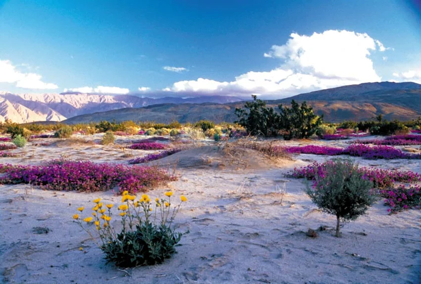
The Desert's Particular Silence
The Colorado Desert ecosystem that surrounds the Fish Creek Mountains is one of the most distinctive in North America — hotter and lower than the neighboring Mojave, with its own assemblage of plants, animals, and geological character. Ocotillo, cholla cactus, brittlebush, and palo verde define the flora; roadrunners, Gambel's quail, and desert tortoise share the ground with those bighorn sheep moving between tinajas. In spring, after a wet winter, wildflowers can transform the bajadas in explosions of color that feel almost impossible in a place so committed to dryness the rest of the year. The Fish Creek Mountains wilderness preserves that ecosystem in a form close to what existed before human infrastructure altered the surrounding lowlands.
From the Air
The Fish Creek Mountains Wilderness sits at 32.974°N, 116.013°W in the Colorado Desert of Imperial County, southeast of the Anza-Borrego Desert State Park. Elevations range from around 500 feet in the washes to over 2,000 feet in the uplands. From altitude, the mountains are clearly visible as a jagged ridge rising from the flat desert floor, with Fish Creek Wash visible to the south. The Salton Sea is visible to the northeast on clear days. Nearest airports include Imperial County Airport (KIPL) approximately 25 miles southeast, and Borrego Valley Airport (L08) about 20 miles northwest. The wilderness has no airstrips. Visibility is typically excellent in this region except during occasional dust storms.
Nearby Stories
- Mountain Warfare Training Camp Michael Monsoor 7.2 km away
- Salton Sea: California's Accidental Apocalypse 8.9 km away
- Mount Laguna Air Force Station 10 km away
- La Jolla Complex 17 km away
- Temecula Massacre 21 km away
- Cooke's Wells Station 36 km away
- Old Plank Road 51 km away
- Poston War Relocation Center 120 km away