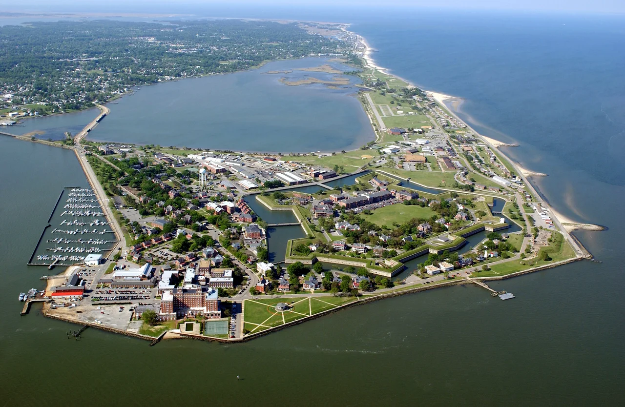

Fort Monroe
On the night of May 23, 1861, three enslaved men rowed a small boat across Hampton Roads and asked for sanctuary at the Union fort on Old Point Comfort. Their names were Shepard Mallory, Frank Baker, and James Townsend, and they had been hired out by their Confederate owner to build a battery aimed at the very fort they now approached. The next morning, Major General Benjamin Butler did something no Union officer had done before. When a Confederate officer arrived under flag of truce to demand their return under the Fugitive Slave Act, Butler refused. Virginia, he said, claimed to be a foreign country. Fine. Then the men were contraband of war, and contraband did not go back. Within months, thousands of enslaved people would walk, ride, and row to Fort Monroe seeking the same answer.
The Gibraltar of the Chesapeake
Captain Christopher Newport's expedition spotted Old Point Comfort in 1607 and immediately understood what they were looking at. The sandy hook at the southern tip of the Virginia Peninsula commanded the narrow channel where the Chesapeake Bay funnels into Hampton Roads, the great natural roadstead where the Elizabeth, Nansemond, and James rivers meet the sea. Whoever held this point held the door to Virginia. The colonists threw up a wooden stockade called Fort Algernourne in 1609. For the next two centuries the site changed names and walls but never stopped being a fort. After the British sailed unopposed up the Chesapeake and burned Washington in 1814, Congress decided enough. Construction on a proper masonry citadel began in 1819. When the work was finally finished in 1834, the six-sided bastion was the largest fort by area ever built on American soil, surrounded by a moat eight feet deep, walls ten feet thick, designed for 412 guns. They called it the Gibraltar of the Chesapeake.
Three Men in a Rowboat
Virginia seceded in April 1861, but Fort Monroe stayed Union because nobody in Richmond could figure out how to take it. By May, Major General Benjamin Butler commanded the garrison, a Massachusetts lawyer and politician with no military training and an unusually good instinct for a legal argument. When Shepard Mallory, Frank Baker, and James Townsend reached his picket lines that May night, Butler had a problem and an opportunity. The Fugitive Slave Act of 1850 required federal officers to return escaped enslaved people to their owners. But Virginia had declared itself out of the Union. Butler reasoned aloud to a Confederate negotiator the next morning: if these men were property being used to build Confederate fortifications, then by Confederate logic they were contraband of war, seizable like any other military supply. The argument was lawyerly, calculated, and revolutionary in effect. The men stayed. Word traveled fast through enslaved communities that the fort would not send them back.
The Flood
Within weeks dozens of escaped families had reached the fort. By August they came by the hundreds. The Army threw up shelters outside the walls; that fall the Great Contraband Camp rose in nearby Hampton, the first of more than a hundred such settlements that would house formerly enslaved people during the war. In Congress, Butler's improvisation became policy. The Confiscation Acts of 1861 and 1862 codified the doctrine, and in March 1862 lawmakers explicitly forbade the military from returning anyone to slavery. Near the fort, a free Black teacher named Mary Peake gathered children under a large oak and taught them to read by daylight, adults by lamplight. She was the first Black teacher hired by the American Missionary Association. The oak she taught beneath, later called the Emancipation Oak, would shelter the first Southern reading of the Emancipation Proclamation in January 1863.
Ironclads and Imprisonment
In March 1862, just offshore from the fort, the Union ironclad USS Monitor fought the Confederate CSS Virginia to a stalemate at the Battle of Hampton Roads, ending the age of wooden warships in a single afternoon. Two months later, Major General George B. McClellan landed his Army of the Potomac at the fort's wharves and marched up the peninsula toward Richmond. The war passed through these gates again and again. At the end, it came full circle. Captured in Georgia in May 1865, Jefferson Davis, the president of a Confederacy that had begun with secession over slavery, was brought to Fort Monroe and confined in a casemate cell carved into the fort's own walls. He spent his first days in irons. Newspaper outrage, North and South, forced their removal. He stayed two years, then was released on bail posted by, among others, Horace Greeley and Cornelius Vanderbilt, and never tried.
The Older Story
Long before Mallory, Baker, and Townsend rowed toward Old Point Comfort, another arrival had reshaped the continent. In August 1619, an English privateer called the White Lion put in at the same point and traded twenty and odd captive Africans, taken from a Portuguese slave ship, for provisions. They were the first documented Africans brought to English North America, the seed of more than two centuries of slavery in the colonies and the United States. One of them was a young woman the colonists called Angela; her real name we do not know. The geographic coincidence is staggering. Slavery in English America began on this sand spit in 1619. The collapse of slavery's federal enforcement began on the same sand spit in 1861. In 2011 President Obama designated Fort Monroe a national monument, his first invocation of the Antiquities Act. In 2021 UNESCO added it to the Slave Route Project as a Site of Memory. The fort still stands, its moat still full, its casemates open to anyone who wants to walk inside the walls where the legal argument that cracked American slavery was first made.
From the Air
Fort Monroe sits at Old Point Comfort, 37.00°N, 76.31°W, the southern tip of the Virginia Peninsula where the Chesapeake Bay narrows into Hampton Roads. The six-sided moated bastion is unmistakable from the air, just southeast of the Hampton Roads Bridge-Tunnel's northern island and Fort Wool's small artificial island in the channel. Best viewed from 2,000-4,000 ft AGL on clear days. Nearby airports: KLFI (Langley AFB, 4 nm NW), KPHF (Newport News/Williamsburg, 12 nm NW), KORF (Norfolk International, 9 nm SSW), KNGU (Norfolk Naval, 8 nm SSW). Class C airspace around KORF; expect coordination with Langley approach.
Nearby Stories
- Battle of Gloucester Point (1861) 3 km away
- Coast Guard Station Cobb Island 3 km away
- Flowerdew Hundred Plantation 11 km away
- Great Dismal Swamp 11 km away
- Cape Charles Lighthouse 14 km away
- False Cape State Park 17 km away
- Cactus Hill 29 km away
- Chowan University 35 km away