Fort near Edam
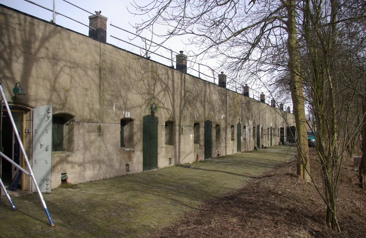
Walk up to the Fort bij Edam on a still summer morning and the first thing you notice is the silence. A grass-covered earth bank rises out of a flat green field, ringed by a moat as straight as a ruler. Reed beds whisper at the water's edge. A heron lifts off, slow and unbothered. Then the bunker comes into view: a low, gray concrete mass tucked into the dike, its arched casemates dark and cool inside, the air carrying that faint mineral smell that old defensive concrete keeps even a century after it was poured. This was built to drown a country. The garden it has become is a quiet kind of victory.
A Ring Around the Capital
The Fort bij Edam is one piece of a much larger machine, the Stelling van Amsterdam, the Defence Line of Amsterdam. Between 1881 and 1914, Dutch engineers built a 135-kilometer ring of forts, batteries, sluices, dikes and pumping stations around their capital, holding it at arm's length from any invading army. There are 45 forts in the line. Each one guards a road, a railway, or a dike that the defenders would not be able to flood. The land between the forts could be put under shallow water, perhaps thirty centimeters deep, within roughly 48 hours, by opening sluices and reversing pumps. Too shallow for boats, too deep for men or horses or wagons, the inundated zone was meant to make the heart of the Netherlands militarily untouchable. The Stelling van Amsterdam was added to the UNESCO World Heritage List in 1996, and since 2021 it is part of the combined Dutch Water Defence Lines listing.
Guarding the Sea Sluices
Fort bij Edam was given a particular job. It sat near the old Zuiderzee dike, watching over the sea locks that controlled the intake of seawater from the Zuiderzee into the surrounding Zeevang polder. In peacetime those sluices kept the polder dry. In wartime they were the valves that would flood it. If an enemy force tried to seize the sluices, or to seize the elevated road on the sea dike that would have been one of the few dry corridors for an attacking army, the fort's guns and garrison were there to stop them. Construction took place in stages. The fort was finished between 1908 and 1914, just in time for the First World War, in which the Netherlands managed to stay neutral. The water defense was never put to its intended test against an invader.
The Day the Flooding Happened
Or rather, almost never. In May 1940, when German forces invaded the Netherlands, the old waterline strategies were dusted off. The Zeevang polder around Fort bij Edam was inundated as part of the desperate Dutch defense. It made no difference. The campaign collapsed in five days, broken not by ground assault into the Stelling but by aerial bombing and the destruction of Rotterdam. The forts, designed for a war that would arrive on horseback and on foot, were obsolete almost from the moment they were finished. Most served quiet supporting roles afterward as ammunition depots and storage. Fort bij Edam was one of the longest-used of all of them, holding ammunition for the Dutch Army right up until 1986. Then the soldiers locked the door and walked out.
Inheritance by Wildlife
The Dutch Army handed the fort to Staatsbosbeheer, the state forestry service, in 1986. With no one inside for years, the place did what unused defensive ground always does in northern Europe. It turned into habitat. The moat became a haven for water birds. The earth banks, never sprayed or grazed, grew up in a tangle of flowering plants and grasses that more intensively managed fields could not match. Bats found roosts in the concrete corridors, drawn by the same constant temperature that had once protected powder magazines from frost. The fort was designated a protected nature reserve. Since 2005, Staatsbosbeheer has leased the site to a foundation that opens it to the public, runs tours of the casemates, and lets visitors walk the moats and listen for nightingales in the reeds.
A Country That Builds Its Future Out of Water
Fort bij Edam is one of the more accessible forts on the Stelling, an easy detour for visitors to the cheese town of Edam, and a useful place to understand what Dutch defense really meant. The Netherlands has fought the sea for so many centuries that its strategists eventually saw water as the most powerful weapon they had. Not a moat, not a barrier, but a flood, deliberately released, drowning your own farmland to save your capital. Standing on the grass bank at Edam, looking across the polder toward the old Zuiderzee dike, you can almost see how it would have worked. Then a hawk drifts overhead, the wind moves the reeds, and the fort is just a quiet hill in a quiet field again.
From the Air
Located at 52.52N, 5.07E, just south of the IJsselmeer's old Zuiderzee coastline and east of the cheese town of Edam. From 1,500-3,000 feet AGL the fort appears as a distinct earth-and-moat geometric shape set in the gridded Zeevang polder. Lelystad (EHLE) is about 25 km east across the IJsselmeer; Schiphol (EHAM) about 26 km southwest; Hilversum (EHHV) about 30 km south. The Markermeerdijk and the long arc of the IJsselmeer dam dominate orientation in clear weather, and the regular geometry of the Beemster and Zeevang polders is unmistakable.
Nearby Stories
- 2008 Vintage Yachting Games 4.4 km away
- Museum Het Leids Wevershuis 7.2 km away
- Vechtstreek 8 km away
- 1973 Dutch Grand Prix 9.3 km away
- Lowlands Festival 10 km away
- HNLMS Johan Maurits van Nassau (1932) 11 km away
- Lemmer 13 km away
- Hoge Veluwe National Park 18 km away